Historical Timeline

About

Mixed bloods of the Upper Monongahela Valley

  • Written by Sachem Great Elk Dancer
  • Category: About
  • Hits: 18754

*Editors Note - "It is important for us to point out that, many of these articles printed in notoweenation.org are from an outside perspective. Unfortunately, when dealing within the Colonial Society construct, it is of the up most importance to provide any documentation considerable. By having to rely on these sources, makes room for much conjecture and bias opinion. When one thinks of a community in existence for over 400 years clinging to it's own culture, in a very hostile environment. Many articles, scientific research and speculation, has only led to more confusion about our people. It is interesting that under these conditions we have come to be known by many names, and labels have been attached to us, thereby projecting a biased view point.  We are a tribe and we have always considered ourselves so, despite the viewpoints of those whom would find it disadvantageous to believe so. It should be simple enough to write our own story, or is it?"

WASHINGTON ACADEMY OF SCIENCES Volume 36 January 15, 1946 No. 1
ETHNOLOGY. — Mixed bloods of the Upper Monongahela Valley, West Virginia. 1
William Harlen Gilbert, Jr., Library of Congress.

We are accustomed to think of West Virginia as a racially homogeneous State populated by Old Americans of English, Scotch, and Scotch-Irish descent with an additional contingent in recent years of Poles and Italians in the mining areas. It may come as somewhat of a surprise to many to learn that there exists in the northern counties of the State a racial island of mixed bloods, known locally as "Guineas," numbering several thousand persons. The origin of this mixed race is unrecorded, and the relative proportion of white, Negro, and Indian blood entering into its makeup is difficult to ascertain. The main seat of this people is in northern Barbour County and southern Taylor County, but small groups are to be found in over half a dozen adjoining counties and in Garrett County, Md. From their homes in the hill country many have gone in recent years to the factory cities of West Virginia, Ohio, and Michigan in search of economic opportunity and social betterment. It is difficult to find a completely acceptable term to designate these mixed people. Stigmatized by white public opinion as a sort of outcast group, they dislike and resent any designation used by outsiders for themselves. They especially resent the terms "Guinea" or "Guinea Nigger," which are most generally applied to them by their white neighbors. 2 There are several possibilities in explaining the origin of this sobriquet.

1 Received December 4, 1945
Many suggestions concerning the Guineas were collected in correspondence with persons interested, notably Mrs. Eva Margaret Carnes, of Roanoke, Va.; Mrs. W. H. Conaway, librarian of Marion County, W. Va., at Fairmont; and Mrs. Howard Grant, of Philippi, W. Va. Mrs. Grant kindly made available extensive genealogical material on the Guineas collected by her late husband. In addition, considerable material was gleaned from the census schedules at the National Archives and at Suitland, Md. In November 1945 a short field trip was made to Philippi and Grafton, W. Va., and extensive interviews were had with W. M. Watkins, attorney of Grafton; Vergil Rohrbough, superintendent of schools in Taylor County; E. A. Hunt, superintendent of schools in Barbour County; Charles W. T. Lockard, editor of the Grafton News; V. C. Willhide, of Grafton; as well as a number of the Guineas themselves. Finally, full credit must be given to the steady cooperation and unfailing enthusiasm of Philip S. Proctor ("Chief" Turkey Tayac), of Washington, D. C, to whose initial suggestion this research is due.

An educated member of this group is said to have worked out a genealogy for them several years ago in which he claimed that an English nobleman went to the Guinea coast of Africa in the early days (possibly as a remittance man), married a native Negro woman, and produced a large family of crossbreeds. Later some of these descendants came to America and became the ancestors of the "Guineas." Hu Maxwell, in his History of Barbour County (pp. 310-311), asserts that the mixed bloods of that county are called "Guineas" under the mistaken notion that they are Guinea Negroes. They are said, however, to have claimed for many years a descent from one of the Guineas (British, French, or Portuguese) in Africa or from one of the Guianas (British, French, or Dutch) in South America, and that their blood was native Negro or Indian.

2 In the following discussion although the word "Guinea" is employed without quotes it is not meant to condone an approbrious epithet. Rather it is used for lack of any other single term to designate these people.

It is worthy of notice that during the nineteenth century the name " Guinea" was applied as an epithet to things or persons of foreign (especially Italian and Polish) and uncertain origin in many parts of northeastern United States (Mencken, 1936, p. 295, a^nd Dictionary of American English 2: 1193).

The term was also applied to Italians of the laboring class because of an incident which took place in early American history when English pennies (jestingly called " Guineas") were circulated in North America and Italian help would receive them freely and even save them as valuable coins. From the coins the term was transferred to their recipients (Roback, p. 37). Undoubtedly there is some linkage of the West Virginia mixed bloods with Italians in the popular mind because the two races are frequently said to intermarry rather freely. The term " Guinea" does not seem, however, to have any significance in relation to the appearance of the mixed bloods, even though "Guinea Negro" has generally meant a very black member of the African race, and it probably has no reference to the yellow-colored gold pieces made from Guinea gold. The mixed bloods are certainly not black, nor can their color be adequately described as yellow. Much more to the point is the locality idea, a vague tradition of a place called "Guinea" from which these mixed people spring. It is said that the name "Guinan" or "Guinea," locally pronounced "Guinny," has long been applied to an area northwest of Philippi in Barbour County where these mixed people are centered. This area, also known as "Chestnut Ridge," was regarded by the whites as lowering the value of property in the adjacent parts owing to the nature of its inhabitants.

In Gloucester County, Va., there is said to be a section called "Guinea Neck" inhabited by a peculiar people, isolated by the coastal land formation. It is possible that the ancestors of the Guineas may have migrated from some such a region westward to Berkeley or Hampshire County in Virginia, where we first hear of them from the census records.

It must be admitted, when all is said and done, that none of these theories of the origin of this term is quite satisfactory, and we are just as much in the dark as before so far as a real etymology of this name is concerned.

There are several other terms sometimes employed to designate the Guineas. One of these is "West Hill Indians" from the community of West Hill, which is their principal center in Taylor County at the present time. Formerly the term "Cecil Indians" was heard, derived from the community of Cecil, now flooded by the Tygart Reservoir. Since many of these people lived near the Grafton & Belington Railway (or G. & B. Railway) and traveled on this line extensively, they were sometimes referred to as the "G. and B. Indians." Sometimes the Guineas employed the circumlocution "Our People" to designate their own kind or again the name "Maleys," referring to the commonest surname (Male) among them.

The family names of the Guineas are limited in number and are the most important items for identification of members. The characteristic names are Adams, Collins, Croston, Dalton, Dorton, Kennedy, Male, Miner or Minard, Newman, Norris, and Prichard. Of these by far the most frequent in occurrence is Male. The name Croston is next in frequency. The Males, who also spell their name as Mayle, Mail, and Mahle, trace their descent back to an ancestor who was said to have come over from England during colonial times. One observer thinks that there may be some connection between the Males and the Malay Race. It is said, moreover, that in the Male clan the white and Indian blood is much more prominent than the Negro. The Crostons, who have also spelled their name Crosten, Chroasten, Croaston, and Crostin, claim to be of Dutch descent and trace their ancestry back to Hampshire County, Va., along with the Males.

There is nothing singular about the personal names of the Guineas, but it is worth noting that nicknames of a sort are frequently applied, such as "Pizen John," "Screech," and "Whistling George." As Jan. 15, 1946 gilbert: mixed bloods of west Virginia in many other groups some given names recur again and again in certain family lines over several generations. The importance of names will be mentioned again in a later context in this paper.

Before proceeding further with a description of this peculiar minority it would be well to note the natural conditions of the geographic environment of these people and how these influences have shaped their manner of life. Barbour and Taylor Counties are located in the northern part of West Virginia along the axis of the Tygart River, a branch of the Monongahela. Barbour County is less rugged than the mountainous counties to the east and south, although there are a few cliffs of some boldness along the watercourses. To the eastward are Laurel and Chestnut Ridges, which sink into hills with rounded tops in Barbour. There are no wide valley areas in "Barbour, however, and the level lands are to be found for the most part on the ridges or uplands. In the bottoms along the Tygart and its branches the " Great Laurel" {Rhododendron maximum) formerly grew most luxuriantly. This plant flourished especially where cool and shady glades prevailed and often covered large areas with impenetrable laurel thickets. In the early days these thi ckets were the retreat of wild animals and a great barrier to the hunter. Since the Tygart flowed northeastward through the center of the county and had numerous branches running out at an angle from its bottoms, it furnished an ideal hiding place for the various refugee families from whom the Guineas are believed to have sprung.

Taylor County is similar in geographic character to Barbour. Ljdng at some distance to the west of the Allegheny ridges, its surface is of an irregular type, with numerous rounded hills. In large areas the land is comparatively level, however, and easily cultivated. As in Barbour County the Tygart River flows through the center of Taylor County but in a northwesterly direction, dividing it into two almost equal parts.

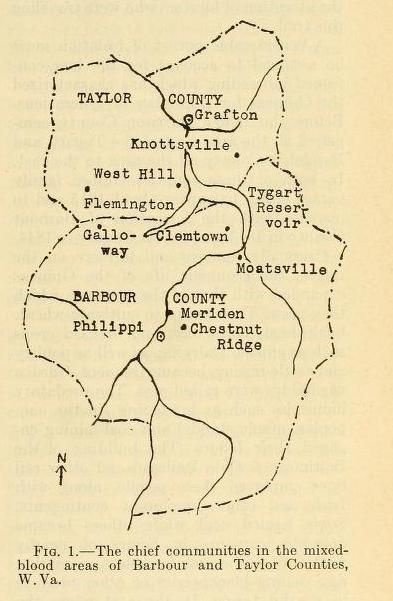
Between Barbour and Taylor Counties the Tygart River executes a change of direction, from a northeasterly to a northwesterly course, and in doing so forms on its left bank a loop or horseshoe-shaped peninsula called "the Narrows." This loop of land, surrounded on three sides by the glades of Tygart River and on the fourth or western side by equally impenetrable thickets of laurel, served as an ideal place for the hiding of runaways and refugees of all kinds. So isolated was this peninsula that even as late as 1880-1900 it was accessible only on horseback.

Not far to the south of the Narrows in Barbour County ran the old Indian Trail called "Horseshoe Run Trail," which started from the region of the Northern Branch of the Potomac in Maryland and ran across the Cheat River, up its Clover River Branch, crossed the Tygart slightly to the north of Philippi, and then con tinued westward into Harrison County (Hu Maxwell, 1899, map). Along this trail bands of Shawnee, Cherokee, Delaware, Hurons, and other tribes made their way in going across the central Alleghenies in the Colonial period. The natural game refuge in the Narrows not far off to the north along the Tygart could not have failed to attract the attention of hunters who were traveling this trail.

A considerable period of isolation must be assumed to account for the long-continued inbreeding which has characterized the Guineas for a number of generations. Before the 1840's Harrison County comprised all the area west of the Tygart, and Randolph County all the area to the east. In both of these counties Guinea family names began to appear about 1815 and to increase with the formation of Barbour County in 1843 and Taylor County in 1844.

Originally hunters and farmers on the ridges, the economic life of the Guineas expanded with that of the region in which they grew. They began to cultivate wheat, buckwheat, corn, hay, and orchard crops such as apples. Dairying, as well as poultry and cattle raising, became frequent. Garden vegetables were raised also. The predatory industries such as lumbering (in the oak, poplar, maple stands) and coal-mining engaged their labors. The building of the Baltimore & Ohio Railroad and other rail lines employed these people, along with Irish and other immigrant contingents. Some hauled coal while others became domestic servants in homes of nearby whites. Some became hucksters on market day, selling blackberries or other produce in nearby towns. In the coal mines the Guineas often worked in gangs made up of their kind. There was undoubtedly considerable contact with the Irish at one time. In the mines of Marion County they encountered at a later date the Poles and Italians of the New Immigration.

As many left the ancestral hive and settled in cities they took up occupations of various sorts and took on new names. In Ohio they settled near Canton, Zanesville, Athens, Chillicothe, Sandusky, and Akron, while some went even as far as Detroit.

In these localities their work varied from gypsum works at Sandusky to gardening in the suburbs of Chillicothe. Migration back and forth into Ohio seems to have been going on from 1880 or earlier.

In Grafton, county seat of Taylor County, the Guineas were almost unknown as a group until recent years. Only once a year, on Memorial Day, did any large number come into town and that was on the occasion of a ball game. Since the building of the Tygart Dam in 1937 and the formation of the Reservoir, which flooded out large areas of their original domain, they have moved increasingly into the suburbs of Grafton, especially Blueville. Grafton restaurants and barber shops have now occasionally put up signs bearing the inscription " white patronage only," and color classification of the mixed bloods has bothered the hospitals and schools.

In Philippi, the county seat of Barbour County, the Guineas have been known from the very foundation of the settlement and were said to have been among the first settlers of the vicinity (1780). The chief settlements in this county are at Chestnut Ridge Community northwest of Philippi, at Meriden nearby on the Tygart, around Moatsville, Lick Run, Buchanan, Galloway, and Clemtown. Clemtown is in the central area of the Narrows. Almost all the Guineas are located in compact masses as small landholders on the ridges in the central and northern parts of the county.

In Taylor County the chief centers are West Hill to the south of Webster, Knottsville, and the vicinity of Flemington. The flooded area around Cecil, now occupied by the Tygart Reservoir, was also a former center. Most of the Guineas are in the southern part of Taylor County, but with the flooding of large areas in 1937 many scattered to other parts, thus giving rise to school troubles. In Marion County coal towns these mixed bloods are said to live in the less-favored parts of town along with the foreign born and the Negroes. The Guineas, however, have not gone to the city and industrial areas to the same extent probably as the West Virginia Negroes.

A number of other counties in northern West Virginia have small groups of Guineas. These are Monongalia (to the north around Morgantown), Grant, Mineral, Preston, and Tucker to the east, Wirt to the west, and Braxton and Randolph on the south. At Big Island Run in Wirt County there has long been a group of the Male family, rather dark in color, who were widely respected by their white neighbors for their industry and honesty. This colony has decreased much by migration in recent years. In Garrett County, western Maryland, the Guineas long had a small colony whose significance will be mentioned later.

As in all cases of unusual little groups of isolated peoples we are constantly met with the query, "What do they look like?" This is a question much easier to pose than to answer. From the accompanying photographs of Guinea school children it may be seen that although there is a considerable range in variation none seem to exhibit the marked features of the Negro nor for that matter of the Indian. Most appear to be of the classification of "Near Whites" or what in the West Indies is called the "Mustee" type. In fact, the Guineas do pass for whites outside of the communities where they have long been known.

Hu Maxwell, in the work previously referred to, speaks of them as "partlycolored people" and says that they vary in color from white to black, often possessing blue eyes and straight hair. According to another observer a single family of brothers and sisters may range from the blackest Negro to a blonde, blue-eyed, fairskinned person, with all the shades in between. Some are perfect Negroes, while others have a marked Indian look. Most of the neighboring whites seem to regard the Guineas as mulattoes, while a few, noting the angular facial features and the hawklike eye and nose, will concede an Indian element. Several informants commented that the Guinea women seemed to be either very ugly or very good looking with few in-betweens.

There can be little doubt that the Guineas, in common with the Wesorts of southern Maryland and the Croatans of North Carolina, are another example of the triple racial admixture of Indian, Negro, and white to be found in a number of places in this country where circumstances have favored their development. Only a detailed anthropometric analysis at some future date will yield the evidence for physical typology and the relative proportions of each group. Several of the Guinea genealogies refer back to full-blood and half-blood Indian ancestry, but the entry of Negro blood into the group is not recorded.

According to local white opinion the habit of inbreeding has weakened the Guineas. Several informants mentioned the deformities of the joints, especially of the arm and leg joints, as occurring at birth among them in a number of instances. Among other defects mentioned as occurring are bad hearing, poor sight, harelips, humpbacked conditions, and mental deficiencies and aberrations. In the line of diseases tuberculosis and typhoid fever are given a prominent place.

The size of the family is said to be above average. One observer mentioned three families in his neighborhood who had fourteen or fifteen children each. A family size of six or seven children is thought to be common within recent years.

The numbers of the Guineas are not subject to easy estimate. Hu Maxwell asserted that at the time he wrote (1899) they totaled 1,000 in Barbour County alone. If this figure be accepted as a conservative estimate, it must be admitted that since that time their numbers must have increased considerably in the county. It is thought by local informants that between 500 and 800 adult voters were of this race in Barbour County during 1944 and that this ought to represent a total population of 3,000 to 4,000. An additional 500 voters in Taylor County of this race would add perhaps 3,000 more, bringing the total for the two counties to a possible 7,000. To this aggregate must be added an unknown number scattered in other counties of West Virginia, Ohio, and Michigan. It is probably safe to say that the total number of the Guineas is somewhere between 7,000 and 8,000. 


Some light may be thrown on the numbers question from Table 1, giving the population by race in Barbour and Taylor Counties from 1850 to 1940 {Negroes in the United States 1920-1932; Negro Population in the United States, 1790-1915). In a rural county such as Barbour it seems unusual to perceive such a marked increase in Negro population from 1920 to 1940. This taken in conjunction with the relative proportions of free Negroes and slaves and of blacks and mulattoes in 1910 would indicate something of the growth in numbers of the Guineas. In Taylor County conditions are reversed and the Negro population seems to outrank the Guineas in numbers.

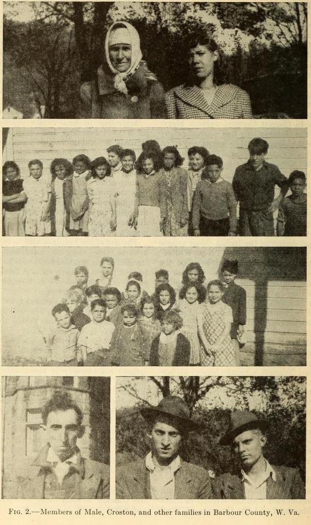
According to the 1930 census only 33 percent of the "Negro" (i.e., nonwhite or mixed) population of Barbour County between the ages of 7 and 13 years were attending school. This contrasts with the West Virginia average figures for these age groups in the "Negro" population of 93.5 percent for that year and a county range within the State (outside of Barbour County) of 89 to 100 percent "colored" attending schooll The same 1930 census gives a figure of 32.3 percent illiteracy for the "Negro" population of Barbour County, which is the highest in the State of West Virginia for that year. The preliminary figures for the 1940 census showed 97.7 percent of the "Negro" population of Barbour County between the ages of 7 and 13 attending school.

The school question regarding the Guineas has been an acute one for a number of years in both Taylor and Barbour Counties. According to West Virginia law white schools are to be separate from colored. For at least 30 years the Guinea children have been attending schools separate from the white. At the present time there are two such schools in Taylor County, a two-room building at West Hill and a one-room structure at Mount Airy, southwest of Knottsville. In Barbour County there are five or six such schools, at Prichard, Lick Run, Buchanan (Sutton School), Meriden (Hanging Rock School), and two at Chestnut Ridge.

School troubles have developed in both counties from time to time over the segregation issue and the classification of these schools as "colored." Apparently, no Negroes attend these Guinea Schools and there are several Negro schools in the two counties also. The following citation from the Grafton News of September 15, 1944, will explain something of the situation faced in Taylor County:

Another problem ... is the matter that concerns the failure to open the Mt. Airy one room colored school. Although the school was scheduled to open, its teacher, Earl G. Mayle, failed to open it Wednesday, September 6, when the other schools of the county began the current term.

From the information available it appears that the residents of that community objected to sending their children to a school that was designated as a colored school. Apparently fearing that some difficulty might develop over the matter Mayle failed to open the school and this week tendered his resignation to the Taylor County Board of Education. Mayle had been the teacher at Mt. Airy for a number of years.

The enrollment at Mt. Airy school, which is located in Knottsville district, last year was 18 pupils. Unofficial observers have it that only seven or eight children reported for school on the opening day, with the other children presumably being kept home by their parents.

According to stories reaching Grafton there appears to be an organized movement, on the part of the parents, objecting to their children attending a school designated as a colored school.

No indication has been made as to what steps the board of education will take toward opening the school or attempting to settle the pertinent question as to whether the children of the many families of mixed or unknown races which reside in that section must attend a colored or white school.

Much of the recent school problem in Taylor County has been due, it is claimed, to the building of the Tygart Dam in 1937 and flooding of area formerly inhabited by many Guinea families with consequent scattering to other parts of the county. Here the children were faced with trouble when they tried to enter the white schools.

In Barbour County there has been considerable trouble where white school administrators have occasionally failed to deal with the problem intelligently. It is said that over 20 members of the Guinea group were in jail at one time over failure to send their children to school. The teachers in the Guinea schools have been mulattoes and Guineas. Within the past year two schools have been burned down by persons unknown. One of these was a new school with much of the latest equipment. A number of court suits have been initiated to determine whether the Guineas were white or colored. Factionalism among the Guineas themselves is blamed for some of the school troubles in this county. One faction is said to desire the monopoly in the use of one school over another.

The religious affiliation of the Guineas appears to be almost entirely Protestant. Many are members of the Free Methodist denomination, while others belong to the United Brethren and the Pentecostal Faith. In Barbour County the major groups among the whites are the Methodists and United Brethren, with the Baptists ranking far behind in numbers. The Negroes of the county, however, appear to be mainly Baptist. In Taylor County, on the other hand, the Baptists are in a majority among the whites with the Methodists somewhat less numerous. There are some half a dozen exclusively Guinea churches in the two counties of which the ones at Chestnut Ridge and West Hill are examples. The Guineas have their own cemetery at Mountain View. Other cemeteries mentioned in connection with their burials are Shiloh, Chestnut Ridge, Silent Grove, Prichard, and Welch.

Politically the Guineas have shown a strong trend toward the Republican Party in an area where the general voting list shows a tendency for Democratic voters to outnumber the Republican. It is claimed that in Barbour County the Guineas hold the balance of power between the two parties. White politicians, it is said, exert every eft^prt to swing the Guinea vote in their favor. One such propounded a theory with which he hoped to win votes from this group several years ago. He asserted that just after the Revolutionary War a scientist bent on breeding a race of supermen brought the ancestors of the Guineas into the Narrows on the Tygart River to raise them in isolation from the rest of the world. We are not told whether this attempt at flattery gained the votes he desired. Another political figure asserted on the witness stand that he would be proud to have his daughter marry a member of the Guinea race. Neither of these statements accorded with local white public opinion.

The contempt of some of the neighboring white people for the Guineas is marked. They are regarded as the dregs of society, as outcasts of little consequence or importance. Others among the whites feel much more sympathetic toward the Guineas and speak of them as capable people when they are given opportunities for advancement. The chief complaints which one hears made are chicken-thieving, bootlegging of illicit liquor, and similar derelictions. Occasionally there are serious altercations within the group, ending in homicide or other serious assaults. As before noted, cases of arson have also been charged to the Guineas.

The mixed bloods, along with other country folk, congregate in the town on Saturday afternoon and evening to gossip and meet their friends. In Philippi the courthouse is a favorite rendezvous for Guineas, and some may be found there at almost any time. In Grafton they congregate in front of the A. and P. Store. Fiddle-playing and singing were favorite recreations with the older generation. They are said to be particularly addicted to the old, well-known Negro spirituals. There is an annual fair held in September by the Guineas near Philippi, and this is entirely organized and conducted by them. Jan. 15, 1946 gilbert: mixed bloods of west Virginia

In the military draft for World War II the Guineas of Taylor County have gone for the most part into the army as whites. Apparently there was some sort of prior agreement among them to register as white rather than as colored. In Barbour County, on the other hand, draftees are said to have gone under both categories. The type of racial classification for the draft can be ascertained by watching the lists published in the newspapers whereby the two races (white and colored) are reported separately.

When Guinea youths migrate or go into the army they often return to the ancestral hearth bringing white girls as brides, and the latter are faced with the social problem of meeting their varicolored in-laws. This situation has been said to result occasionally in divorce or annulment due to the difficulties of adjustment. One such case was mentioned in which a dramatic racial denouement occurred when a wealthy bride drove up to the poor dwelling of her husband's people in her "fancy" car and was shocked beyond words to discover that they were locally considered as colored.

In recent years there has been apparently an increasing resistance on the part of the Guineas to their classification as "colored." One doctor in a town hospital had trouble with a Guinea mother who threatened a lawsuit because he had listed the child born to her as "colored." Permanent migration out of Barbour and Taylor Counties has been recommended by local white officials as the best solution for the individual Guinea. By moving to a community in which there is no knowledge of the Guineas as a group it is quite possible for the individual to pass into the white classification in many instances.

Two incidents of this type might be cited. In a nearby county seat there was a Guinea man of unusual physique, tall and sturdy, who worked with a paper and pulp company. As time went on, by reason of his skill and industry, he was promoted to the position of foreman and finally to plant superintendent. Possessed of a good income and reputation, he stood high in the estimation of his neighbors in spite of the known fact that he was of mixed-blood descent. His attractive daughter was sent to a girls' finishing school in Virginia and passed without question as white. A man instructor was attracted to her and the two were married. Soon afterward the new bridegroom met his father-in-law and the latter took him aside and told him the whole story of the Guinea racial background with the suggestion that the marriage might be annulled if he so desired. The bridegroom did not flinch, however, and accepted the situation, taking a position with the paper mill, and never returned to his former teaching post. He and his wi/e never had any offspring, however, so the story goes.

In another instance a Guinea youth played on a high-school football team in a town nearby and made a splendid record. Subsequently he went to a Virginia college for four years, graduated, and married into a white family of good status with apparently no trouble ever arising over his race.

In the local courts of Barbour and Taylor Counties a series of lawsuits over school attendance took extensive testimony from neighbors, local reputation, birth records, marriage records, voting records, and school and church attendance records, regarding the race of the Guineas. In the census records persons with Guinea family names in Barbour and Taylor Counties are classified as "mulatto" in the period from 1810 to 1880.

If there is such a thing as group character one of the traits assignable to the Guineas is an interest in skill and cleverness. It takes the form of a real dexterity and an emphasis on the clever and the genuine use of skill. At West Hill the Guineas are said to have a special "telegraphic" system of their own for transmitting news almost instantaneously, for everybody there seems to be immediately aware of any stranger approaching the top of the hill. Quite a number, moreover, have gone to college and later served as teachers or professional men among their own kind or elsewhere. There is apparently a very marked emphasis on education and higher learning.

An instance of cleverness may be cited from a case occurring about 40 years ago. A certain mixed-blood man, A. N., owned an old gristmill in the Cove District of Barbour County. For several years his son R. A. was with a circus but later came back to work in the mill and put the tricks he had learned into practice to mystify his neighbors. It soon came to be noised about that the old mill was haunted. Boxes and barrels would move mysteriously across the floor and other strange things happened. The local populace for miles around came to see the curious antics of the ghost. A certain "Capt." J. R. undertook to "lay" the ghost. He went to the mill one evening and after considerable wrangling R. A. consented to be tied up; this, "Capt." said, would show whether R. A. was the ghost. Barrels began to roll over the floor and down the stairs, while R. A. struggled with his bonds and shouted loudly about losing his grain. A rock or small piece of quartz dropped mysteriously upon a scale, and "Capt." wrapped it up in his handkerchief and took it home for examination in the daylight. Upon arriving home he locked the handkerchief and quartz in the drawer. When morning came he unlocked the drawer, took out the handkerchief and untied it, but the quartz had disappeared. That put an end to "Capt.'s" attempt to lay the ghost.

According to one informant the Guineas can be divided into three sets, locally illustrative of variation in character. These are (1) the West Hill group of Taylor County, (2) the Chestnut Ridge group of Barbour County, and (3) the Clemtown group on the borders of Barbour and Taylor Counties.

The first group were characterized by fairly good behavior, industriousness, and the fact that they got along very well with their neighbors. They were still regarded as in a separate status from the whites, however, and a few years ago when one of these persons, a prosperous farmer, attempted to buy a farm in another part of Taylor County where Guineas were not previously settled the white neighbors got together and effectively barred the sale.

The second group lived in an isolated section somewhat apart from all neighbors and were extremely backward because of the poor quality of their land. They were said also to be more "mixed up" racially than the other two groups. Their position was definitely not good.

The third group had good farmland and for a long time were very progressive and frequently prosperous rural folk. They kept up their taxes and were careful of their racial affiliations, mixing only with the equally respected West Hill "crowd." But during Prohibition they went in rather heavily for bootlegging, and this has sadly deteriorated their previous good reputation in the region.

The Guineas as a whole are strongly characterized by the spirit of cooperation in spite of the factions and internal disputes. Whenever the advantage of the group as a whole is at stake they are quick to notice it and to bring to bear a common effort. This is shown in the attitude regarding school classification as "colored" and in the agreement to register uniformly in one county as white for the draft. As previously noticed, the phrase "our people," is employed for themselves and betrays a certain degree of consciousness of kind. A certain aggressiveness is also exemplified in the interest in court or legal procedures, especially those involving their own status.

The history of a racial minority of this type must be gleaned from local records of births, deaths, and marriages and from the census records of persons with the Guinea family names in the "free colored" or the "mulatto" categories. One thing that can be established from the outset is that for a long time the Guineas have been intermarrying among themselves and that matings with outsiders have been definitely in a minority. For instance, an examination of 31 marriages of Collinses from 1856 to 1915 discloses that only three were with persons of non-Guinea family name (Douglas, Stalnaker, and Davis), about 10 percent. Similarly, in a list of 81 Croston marriages from 1858 to 1931 only 8 were with persons of nonGuinea family names (Kisner, Hunter, Hendrick, Parsons, DeCost, Ross, Wilson, and Moore), again about 10 percent.

In explaining the origin of the Guineas Jan. 15, 1946 gilbert: mixed bloods of west Virginia some attention must be given to the existence of still smaller knots of people settled here and there in the region farther east. For instance, there is the small colony of half a dozen families of mixed Indian descent at present located on the Blue Ridge Mountains near Boonesboro (Washington County), Md. These may be descended from two family groups named Perl and Patterson, which were located in the vicinity of Jefferson, Lander, and Catoctin Mills in 1889. In that year James Mooney, the Smithsonian anthropologist, sent out questionnaire forms to a number of communities in Maryland, Delaware, and North Carolina on various topics having to do with Indians and Indian remains still in the vicinity. The results are still in the archives of the Bureau of American Ethnology at Washington. Among them is the notice of the above-mentioned small group.

He gives similar notice about the existence of three or four families going by the name of Mail or Male, living in the extreme western part of Maryland near Oakland and Deer Park who had traditionally migrated from Hampshire County, Va., a few generations before. It is likely that from these much smaller pockets of Indian remnants the recruits were drawn together sometime during the nineteenth century to form the nucleus of the larger present-day settlement of Guineas in Barbour and Taylor Counties, W. Va. (Gilbert, 1946).

In Table 2 is shown the development of Guinea family names in selected counties of Virginia, later West Virginia, and the increase of their number with each decade is evidently an index of some process of multiplication within an isolated area and with consistent inbreeding. The history of the race, then, is written largely in the increase in the family names in limited areas of the State (Woodson, 1925, pp. 175, 187, 188).

The name "Male" occurs in a few scattered instances in Chesterfield, Norfolk, and Hampshire Counties of Virginia, in York and Bedford Counties of Pennsylvania, and in New York City in the census lists of 1784 and 1790 for these areas. None of these are in connection with persons designated as nonwhite.

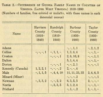
In the Virginia census of 1782-1784 there were a number of Collinses, Norrises, Pritchards, and Newmans, whose racial character, outside of the fact that they were not slaves, is unmentioned. The county records seem to indicate that the Newmans stem from Loudon County, Va., while the Crostons and the Males both appear originally in Hampshire County of that state. According to one account the Pritchards are of slave origin from Hampshire County, Va. The Minards have a tradition of their Pennsylvania origin. While the Newmans claim an Irish background, and the Males an English, the Minards and Crostons assert a Dutch origin for their family names. Both Norrises and Males have ancestors of Indian or half -Indian race in their family genealogies. One or two cases of Portuguese intermarriage with Males are recorded. It is interesting to note that one theory of Guinea origins traces them back to Spaniards, perhaps some lost followers of De Soto. The name Adams is a rare one among the Guineas but is shared by them with mixed Indian groups in Virginia and with the Wesorts in Maryland, another mixed group. The name Collins, it is also worth while to note, is one of the commonest surnames among the Melungeons of Ten12  nessee, a mixed group similar to the Guineas. In addition to Adams, the surname Newman is shared by the Guineas with the Wesorts of Maryland. The name Norris or Morris is shared with the Nanticoke mixed bloods of Delaware.

The derivation, then, of the Guineas is an extremely complex picture. We can reconstruct their history tentatively on the basis of partly runaway slaves, partly freedmen, partly mulattoes, some stray Indian families, and perhaps partly recruits from neighboring mixed peoples of the same kind such as the Virginia tidewater groups, the Wesorts and the Melungeons. How this group first came together, why certain family lines only were selected for the inmarrying group, and where the dividing line exists between true mulatto and Guinea, are unclear parts of the picture. The tendency to marry only within certain family lines reminds one of the preferential mating rules of some of the primitive Indian societies of North America.

Another puzzling problem is the origin of the stigmatization attaching to the Guineas. There are many families of West Virginia, as in other parts of the United States, who are proud to claim Indian blood in their veins and who are not stigmatized for it. In the case of the Guineas the inference is that they are all in some degree part Negro in blood, but this again is difficult to prove and also difficult to believe. There may be a lingering idea that these mixed bloods are mainly of runaway slave origin.

In considering the future prospects of the Guineas it can not be too strongly emphasized that the more thoroughly they are studied and their origin understood the better will be their chances of ultimate absorption and acceptance as members of the larger ethnic group of undifferentiated citizens in the United States. Already they have achieved progress in this direction as compared with some of their similar mixed relatives in neighboring States. It might be worth while to itemize a few of their characteristics in comparison with the Wesorts, a similar racially mixed group some 200 miles eastward near the mouth of the Potomac (Gilbert, 1945).

The environmental circumstances of the two groups are somewhat contrasting, the Wesorts being located on the Coastal Plain and in the neighborhood of tidal or neartidal swamps, while the Guineas are located in the Allegheny Plateau area on the ridges and narrow river valleys protected by laurel thickets. The economic development of the Wesorts has been mainly along agricultural lines, while that of the Guineas has been in both agriculture and the extractive industry of mining. The Wesorts have been forced by a variety of factors into Negro institutions or into institutions whose membership is largely Negro (schools and churches), while the Guineas have segregated out in their own schools and churches. One of the important factors in Wesort development has been the large amount of trade relationships these people have had with Negroes, especially in urban or suburban environment. The Wesorts have many, if not most of their business dealings with Negroes, such as selling farm produce and buying up material for salvage. The Guineas do not seem to have gone much into trade, and where they have the business dealings have been more with whites. The Guinea churches, being organized on an independent congregational basis, have been easier to segregate by themselves than in the case of the Wesorts, who are Roman Catholics and attend parish churches in which either Negroes or whites preponderate.

The location of the Wesorts is in an area where Negroes make up practically half of the population, while that of the Guineas is in an area where Negroes are scarcely as numerous as the Guineas themselves. The result is a situation of "southern" social surroundings for the former and • 'northern' ' social surroundings for the latter. The overflow of Wesort population has been into cities such as Washington and Baltimore with strongly fixed racial traditions of segregation, while that of the Guineas has been to cities of Ohio and Michigan where conditions are fluid and possibilities of "passing" are more frequent.

In the rural environment there has been Jan. 15, 1946 gilbert: mixed bloods of west Virginia 13 much more of the dependency relationship in the case of the Wesorts than in the case of the Guineas. The former have been mainly tenant farmers, scattered about over a wide area, while the latter have been primarily small landholders concentrated in large masses within small neighborhoods. The economic life of the Guineas is considerably more variegated than that of the Wesorts and their possibilities of making a living at present seem much better. On the other hand, there is no tradition of craftsmanship or fine artisan work among the Guineas as there has been in past times among the Wesorts.

The sum and substance of this comparison seems to indicate an increasing identification, in the case of the Wesorts, with the Negro minority while on the contrary the ties of the Guineas have become increasingly stronger with the whites. In a biracial society such as the United States has long possessed the in-betweens tend in the long run to go over as a body into either the one or the other of the two larger groups. In the present comparison the Guineas seem in a better way to solve their minority racial status problem than do the Wesorts through absorption in the larger racial group.

In the case of the Guineas independent organization for group ends would seem to be largely superfluous, if not positively harmful, in the sense of emphasizing minority status. In the case of Wesorts it would seem that group organization would be of the greatest value in preserving an identity of group status which is fast being lost under present tendencies.

It is to be hoped that the present school controversies involving the Guineas will soon be solved. Recognition that Guinea schools are not "Negro" would be of the greatest assistance in this direction. A policy of encouraging greater dispersal for these mixed bloods would also be helpful. A modification of segregation to the extent of granting greater leeway for social participation in white churches and schools by Guineas is to be anticipated. In the long run complete absorption of these mixed bloods into the white community is very likely to take place.

LITERATURE CITED
Anonymous. Board will air Mt. Airy School problem Thursday. Grafton (W. Va.) News, Sept. 15, 1944, p. 1, col. 2.

Craigie, Sir William A., and Hulbert, J. R. (editors). A dictionary of American English!: 1193. Chicago, 1940.

Gilbert, William H., Jr. The Guineas of West Virginia (brief communication). Amer. Anthrop. 48. 1946. .
The Wesorts of southern Maryland. An outcasted group. Journ. Washington Acad. Sci. 35 (8) : 237-246. 1945.

Maxwell, Hu. The history of Barbour County, West Virginia: 310-311. Morgantown, W. Va., 1899.

Mencken, H. L. The American language: 295. New York, 1936.

Roback, A. A. A dictionary of international slurs: 37. Cambridge, Mass., 1944.

U. S. Census Bureau. Negroes in the United States, 1920-1932. Washington, 1935. .
Negro population in the United States, 1790-1915. Washington, 1918.

Woodson, Carter G. Free Negro heads of families in the United States in 1830: 175, 187, 188. Washington (Association for the Study of Negro Life and History), 1925


  • Written by Sachem Great Elk Dancer
  • Category: About
  • Hits: 15004


We present this historical timeline. We are still adding to this timeline so check back for current updates. It is an effort to show the many changes, alliances, historic events, evolution of race identification, governmental patterns and specifically how our Notoweega family / Allied Peoples, has been infused in all these events. (Most events can be verified, by simply "google-ling" selected events.)

circa 1459 Iroquois League according to Onondaga.
1534 First encounters with Europeans. The Cherokee as “Ani-Suwa‟li”, or “the Suwali people.” The Cheraw Tribe was actually a loose confederation of tribes who all spoke a version of the Siouan language. Known by such general names as the Cheroenhaka, Esaw, Isaw, Sara, and Saraw, this confederacy of eastern Siouan peoples included the Manahoac, Hassinunga, Shakori, Eno, Meherrin, Nahyssan, Nottaway, Occaneechi, Saponi, and Tutelo.
1540 De Soto visits Creek Town. Ranjel mentions as a town near Cofitachequi where the bulk of De Soto's army was sent for provisions.
1570 Iroquois War.
1590 Colony at Roanoke and all were eventually absorbed into the surrounding American Indian tribes. By the time the census came around, all of the people were gone. The ordeal became known as the lost colony and it's people "Croatans."
  Hurons receive new Nations.
1600 Nottaway or Notowega: 1,500.
1607 Jamestown, Virginia, founded.
1608 "Thomas Mayle" is listed on the 2nd Virginia Charter at Jamestown.
1610 French missionaries, of the Jesuit r order. They found a village of the Ottawas near Parent Creek (afterward named " Bloody Run "), and " Conner's Creek." The Hurons occupied the present site of Detroit. The Ottawas also controlled Belle Isle. The Pottawatomies were the most powerful and not only controlled Grosse Isle, but also the lake country, embraced in the present county of Oakland. The whole territory of what became Michigan was inhabited by the following Indian tribes: Ottawas, Ojibewas, Chippewas, Pottawatomies, Hurons and Miamis. The Iroquois composed the five nations, and the Delawares called themselves " Leni Leapes " (original men), and claimed to be Grandfathers of over forty Indian nations. The "Delewares" were always allies of the English, and were considered by the English as representing the intelligence and were the most cultivated of all the other tribes. They were the controlling influence among the  tribes constituting the five nations, and were direct opponents of those constituting the tribes favoring French supremacy. The name given to Detroit by the Indians was Waweatonong.
1613 Found four houses built "at Manhattan isle, in Hudson's River." These, it would seem, were the buildings erected to house the crew of the burned "Tiger," while they were building the yacht "Onrust." It does not seem that Christiaensen, who was apparently in supreme charge of the American operations of the grouped Dutch merchants, erected a fort on Manhattan at that time. The fort erected in 1614 or 1615, on Castle Island, at the head of navigation, was probably the first built by the Dutch in New Netherland.
  The Two Row Wampum Treaty, also known as Guswhenta or Kaswhenta and as the Tawagonshi Agreement of 1613 or the Tawagonshi Treaty, is an agreement said to have been made between representatives of the Five Nations of the Iroquois (Haudenosaunee) and representatives of the Dutch government
1614 Carauntouan at war.
1615 Champlain attacks Onieda Fort.
  Champlain and Father Joseph le Caron visit Huron, French refer to them as Agnonha or Iron Men.
1616 Daillon visits the Neutrals.
1617 Treaty of Tawasentha, the first to be completed between Indians and the Hollanders, "was signed" in 1617, "in all the solemn forms of Indian diplomacy." The Mohawks were the prime movers of the treaty, but at the invitation of the Iroquois confederacy many other subordinate tribes attended the council. The supremacy of the Five Confederated Nations was acknowledged by the lesser tribes represented, and the solemn treaty of amity and alliance with the Dutch was signed. There was an interesting ceremonial. The Belt of Peace was held fast at one end by the Iroquois and at the other by the Dutch, the lesser parties resting under its middle. The calumet was smoked, and the tomahawk buried. Over it the Dutch declared that "they would erect a church, so that none should dig it up again."
1622 Champlain reports Peace Between Iroquois and Algonquins.
1624 Iroquois and Algonquins conclude peace.
1626 Mahicans drive out Mohawks from their lower Castle on the Mohawk River east of Schoharie Creek.
1627 Seneca kill French Ambassador and Canadian Indians, Iroquois and Algonquins resume warring.
1630 Van Rensselear, a Dutchman, takes advantage of the Mohicans leaving the area because of war, acquires much of their land. The Dutch soon learned to make Wampum using better methods. (unfair business practices).
1630-1700 Beaver War. grew out of a struggle over the fur trade, but soon passed beyond that. Thousands of refugees (Huron, Tionontati, Ottawa, Potawatomi, Mascouten, Fox, Sauk, and Kickapoo) fled west and relocated to northern Wisconsin and upper Michigan. Similar pressures also forced the Ojibwe (Chippewa) to expand their territory south and west from Sault Ste. Marie.
1632 War with Canadian Indians continue.
1633 Senekas defeat Hurons.
1635 A group of Monongahela refugees resettled in south-central Virginia at Halifax County.
1637 The Pequot War - In 1633 the English Puritan settlements at Plimoth and Massachusetts Bay Colonies had begun expanding into the rich Connecticut River Valley to accommodate the steady stream of new emigrants from England. Other than the hardship of the journey and the difficulty of building homes in what the Puritans consider a wilderness, only one major obstacle threatened the security of the expanding settlements: the Pequots. English Puritan troops, with the help of Mohegan and Narragansett allies, burned the village and killed the estimated 400-700 Pequots inside.
1641 Governor Montmagny build forts along the Sorel and Iroqouis River.
1643 Two thousand warriors of the Neutral Nation attacked a town of the Nation of Fire.
1645 Captain William Claiborne tried unsuccessfully to establish treaty relations with the Rappahannocks, as the Rappahannocks had not participated in the Pamunkey-led uprising in 1644, and the English wanted to `treat with the Rappahannocks or any other Indians not in amity with Opechancanough, concerning serving the county against the Pamunkeys.
  Algonquins make peace with the Dutch at "New Amsterdam".
1646 Hurons request aid of the kindred Anadastes against the Iroqouis.
1647 Hurons made an aggressive alliance with the Susquehannocks, who agreed to lift the hatchet when the Hurons gave the word.
1649 Petuns are defeated to ruins.
1650-60 The Anadastes War.
1650 - 1651 Neutrals are dispersed.
1652 Mahicans settlement at Schaghictoke.
1654 Eries are dispersed.
1654-56 Saponi war in Virginia.
1657 The English forced most of the Powhatan remnants onto reservations in Virginia.
1658 "Sturgeon War" between Menominee and the Ojibwe.
1660 Mohawks invite Indians living near New Amsterdam to come and live with them, and made a southern journey to reconcile the Minquas and Senecas.
  Father Reni Mesnard established a church at the Bay St. Theresa, on the south shore of Lake Superior. He was lost in the forests of Keweenaw. Subsequently his cassock and breviary were found in the possession of the Soux. The Indian tribes about Detroit were the Hurons, Ottawas, Ojibewas, Pottawatomies, Ollogamies and Mascoutins.
1662 Mohawks and Oniedas send a party against the Ottowas, they are defeated by the Sauteurs.
  Andastes referred to as Minquas, the Black Minquas come to their aid, so called Black Minquas, the Eries being the Black Minquas. so named from their black badges.
1664 First treaty between Iroqouis and English in New York.
  Governor Couercelle goes against the Mohawks. Learning the Mohawks and Oniedas left for war against the Wampum-makers.
1666 Covenant Chain - Iroqouis and English.
  New France, in order to punish the Iroquois for their raids on her fur fleets, launched two expeditions under Courcelles and Tracy. The first was a failure; but the second, though it encountered few Mohawks (they having wisely vanished into the woods) burned villages and destroyed quantities of stored corn.
  French missions of the Black Robes resumed.
1667 Ottowawaes Dionendadees & Twichtwicks came & gave Presents to Govr. Nicolls Desyreing that ye 5 nations may open a Path for them to come & Trade wth ye English ; which they did & "diverse men" have been here from time to time of those far nations of Indians. Albany, N.Y.
1668 Wappingers join Mohawks against the Mahicans.
1671 Kandiaronk a young man in his twenties, Later Huron Chief known as the Rat, with the Wyandot finally settled at Michilimakinac.
1672 Sixty young Andaste (Susquehannocks, Conestogas), of the class known as "Burnt-Knives," or "Soft-Metals routes Senecas and Cayugas.
  Mohawks and Mahicans conclude a Peace Treaty in Albany.
1675 Anadastes are overborne by the Seneca.
  Conestoga (Anadastes) at war with Virginia and Maryland.
  Nottoway's and Meherrins send warriors to assist the English against the Susquehannocks.
  King Philips War is raging.
  Seneca wish to exterminate the Susquehannas or Anadastes. But Mohawks said they were their brothers and children and might live with them.
  Bacon's Rebellion, began with a raid by the Doeg Indians on the plantation of Thomas Mathews, located in the Northern Neck section of Virginia near the Potomac River. Several of the Doegs were killed in the raid, which began in a dispute over the nonpayment of some items Mathews had apparently obtained from the tribe. The situation became critical when, in a retaliatory strike by the colonists, they attacked the wrong Indians, the Susquehanaugs, which caused large scale Indian raids to begin.
  "Menheyricks." (Meherrin) named after the river where they were found. After the disruption of the Susquehana Indians, a part of them seem to have joined this tribe, giving rise to the belief that the latter were all of Susquehanna or Conestoga descent.
1676 Susquehannocks Finding themselves surrounded by enemies on all sides, a portion of them abandoned their country and took refuge with the Occaneechi on Roanoke river, while the rest remained in Pennsylvania. A quarrel occurred soon with the Occaneechi, who made common cause with the whites against the fugitive Conestoga, who were compelled to return to Susquehanna river and submit to the Iroquois.
1676 The Swedes and Dutch called theuadroque, Sasquesahanough, Testnigh, and Utchowig. The Meherrin, on the river of that name in south east Virginia, were officially reported to be am Minqua.
1675-76 Attaock, Carantouan, Cepowig, Quadroque, Sasquesahanough, Testnigh, and Utchowig. The Meherrin, on the river of that name in south east were officially reported to be a band of the Conestoga driven south by the Virginians during Bacon's rebellion.
1677 Treaty of Peace, Susquehannas and Iroqouis.
  Treaty of Peace, between Charles II, Queen of Pamunkey, Queen of Waonoke, Chief of the Nancymond Indians, Chief of the Nottoways and Captain John West, Son of the Queen of Pamunkey. XVI. That every Indian King and Queen in the month of March every yeare with some of theire great men tender their obedience to the R’t Honourable his Majesties Govern’r at the place of his residence, wherever it shall be, and then and there pay the accustomed rent of twentie beaver skinns, to the Govern’r and alsoe their quit rent aforesaid, in acknowledgment that they hold their Crownes, and Lands of the great King of England. Signatories of this treaty were deemed “sovereign subjects of the crown”. As recently as the first decade of the 21st century this treaty was applied to a court case involving Virginia Indians.
1682 The Virginia Colonial Council established a reservation for the Rappahannock Indians of 3,474 acres`about the town where they dwelt.
  Treaty at Albany between Iroqouis and Maryland.
  Proposal made to The Mahikander and Esopus Indians, otherwise called Warrenacockse, and to the Catskill Indians by Col. Philemon Lloyd and Colonel Henry Coursey, for the right honorable Lord Baltimore, Lord Proprietor of Maryland, and all his Majesty's subjects of Virginia and Maryland, in the Courthouse of Albany, the 19th of July. Names of ye Mahikander Sachims. Wickepee, Joris, Machanuk, Watt hawitt, Puhketay a Squae, Snotce & kehomahak. The Cattskills Sachims, Skermerhoorn, Mataseet, kochkotee a Squae, fan d Backes, Tatamshait. The Esopus Indians, Culpuwaan, Camirawechak, Mamaruchqua a Squae. Interpreted p mr. Gerret van Slichtenhorst.
  law of 1682 was made known. and it allowed the enslavement of Indians.
1685 Propositions made by the north Indians that are come from Canida being about 56 in number besides: xoo: women & Children there Sachim is called Sadochquis accompanyed with the Indians of Schaghkook in ye Court house of Albany ye I8th of July.
  Piscataway, or Conoy Indians from Maryland, first presented themselves to the Governor and Council in New York City on August 1.
1687 Denonville's invasion of the Seneca country.
1694 Treaty at Albany between Governor Fletcher and the Five Nations.
1696 William Penn transferred the Delaware to the territory, bounding the western branches of the middle reaches of Monongahela River.
1701 Penn makes treaty with the Sachems of Susquehannah Minquas or Conestoga, Shawaneese, Ganawese (Conoy's) or Piscataway's and Brother of Onadaga Sachem.
  The French establish a settlement at Detroit.
  The Montreal Treaty of 1701, which marked a turning point in Iroquois history, came about as a result of the uneasiness felt by the Five Nations at the phenomenal growth and expansion of their English allies. They saw the need of a counter-balancing weight on the international scales.
1702-13 Queen Anne's War.
1706 Vandreuil sends Joncaire to Michilimackinac to maintain peace between the Ottawas and Iroqouis.
1707 Shawnees start back to Kentucky to build their new Eskippaki at Indian Old Fields. In support of this Catahecassa or Black Hoof, tells Colonel John Johnston, the Federal Indian agent amongst the Ohio and Indiana tribes from 1812 to 1842, that his people came from the South where they had lived not far from the sea.
1709 Chiefs of the Mingoes, Ganawese and Delawares on the Susquehanna, purpose going to Onondangas with 24 Belts of Wampum as tributes.
1710 Tuscarora makes petition to the Provincial Government of Pennsylvania. In addition to the Tuscarora emissaries, they found Civility and four other Conestoga chiefs ("Senecas"), and Opessa, *the head chief of the Shawnee. In the presence of these officials the Tuscarora ambassadors delivered. their proposals, attested by eight wampum belts.
1711 Chief Hancock killed 120 colonists on Sept 22, 1711, took others captive, burned houses, and seized crops and livestock in Bath County.  Then white settlers retaliated.  The Tuscarora War was put into motion.
1711-13 Tuscarora War.
1712 The Fox Wars begin, Civil wars between members of the Great Lakes alliance.
1713 The confederated eastern Siouan Nations signed a Treaty of Peace with the Virginia Colonial government at Williamsburg.
  Treaty of Utretch. Series of treaties concluding the War of the Spanish Succession. One series was signed between France and other European powers; another series was signed between Spain and other powers. France concluded treaties with Britain, the Dutch Republic, Prussia, Portugal, and Savoy, in which it ceded various territories, including regions in Canada, to Britain.

France was required to recognize British soverainty over the Iroquois and commerce with the Far Indians was to be open to traders of all nations.
1715 Seventy of the southern Tuscarora went to SC to assist against the Yamasee. Those 70 warriors later asked permission to have their wives and children join them, and settled near Port Royal, SC.
  Waccamaw: 610 in 1715.  Found on the Waccamaw River in NC and the Lower Pee Dee River in SC.  Some may have moved to Lumber River and Green Swamp areas of N.C., with descendants among the Tuscarora, Lumbee and Waccamaw-Siouan.  Population in 2000 was Waccamaw-Siouan 2,000 in Columbus, Bladen Counties, NC.
1716 King Hagler, Catawba Head Sachem. Admits that his people come from so many different Nations, that it is hard to tell whom have which origins, there fore they refer to themselves as the "Yessah" meaning "The People."
1717 Black Hoof. It is estimated he was born in northwest Ohio.
  Conference at Georgetown on Arrowsick Island.
  Treaty at Conestogoe, Present were Gov. Kieth, Richard Hill, Caleb Pusey, Johnathan Dickenson, Col. John Fench, James Logan, Secretary, "with divers gentlemen," Deputies from the Senecas, Onondagas and Csyugas, Interpreters Smith the Gawanese-Indian, John Cartledge and James le Tort.
Governor Keith tells the Conestoga Indians that he has arranged with Virginia to make the Potomac the boundary of the hunting between them and the Virginia Indians. Gheasont, a Seneca complains of the sale of liquor.
1722 Saponi and Tutelo and allied tribes, make treaty at Albany. Peace was declared between the northern Indians (Notoweega) and the Virginia and Carolina tribes, the Blue Ridge and thePotomac being the boundary line.
  The Meiponski, Saponi, Occaneechi, Tutelo, Steakenock (Stegaroki), Catawba living near Fort Christana.
1723 Treaty of Peace and Friendship at Albany, between Pennsylvania and the Chiefs of Indians of the Five Nations.
1728 Two Indian Treaties held at Conestogoe and Philadelphia. Attended by Lt. Gov. Gordon and Indians of the Conestoga, Delaware, Shawnese and Canawese tribes. Over troubles at Mahnatawny Iron Works. Land Issues.
1730 Savannahs move to Ohio.
  Virginia  employs an interpreter to “the Saponi and Occaneechi Indians” as late as 1730.
1732  Lumbee Henry Berry Lowry and James Lowry are granted land on the Lowry Swamp east of the Lumber River.
  Sapony and the Saura Indians living in the Catawba Nation petitioned the colony of Virginia for permission to move to their old home. Virginia granted them the right to return and seat themselves on any land not already granted on the Roanoke or Appomattox Rivers.
1733 "Chief" Micajah Bunch was the King of the Blackwater Melungeonites was born near where the Saponi tribe lived, King Micajah was part Melungeon and part Cherokee. He is believed to be the first melungeon to be in the Newman Ridge area. (Hancock County, Tenn).
  Oglethorpe’s First Treaty with the Lower Creeks at Savannah, May 21.
1734 Saponi were settled at Buttrum Town, Virginia (in modern Pittsylvania County, near Dan River, close to Rockingham county, North Carolina, called "Goinstown." Located near Old Upper Saura or Cheraw Town. Saponi in southern Virginia were associated at times with Nottoway and Nansemond (a band sometimes called "Pochick" or "Pochyackee").
  In Albany, NY. Two Sachems of the Mohoggs waited on his Honour George Clark Esq, in behalf of themselves, Onedes, Onondanges and Tuskararoes desiring that his honour would be pleased.  To review brighten and to strengthen the Covenant Chain.
  Conference at Deerfield, between Governor Belcher and the Caughnawagas, St. Francis, Housstonnoucs, Schatigcokes and Mohegan Tribes. Peace was renewed.
1735 Catawbas threaten the Nottoways.
1738 John Harris as the King of the Cheraw. Gradually merging with the Catawba, this band of Cheraw Indians had a population of 70 people in 1768.
1738-39 Smallpox epidemic ravages Indian population in North Carolina.
1739 England declares war on Spain. American Indians fight the Spanish.
  The Wyandots, a branch of the Huron people, moves into Ohio.
1740 French document mentions, Andasses (Anadastes) among the Cherokee.
  French settle Crown Point.
  George Clark prevails upon the Six Nations to include all Indian Nations lying to the westward and southward as far as the Mississippi in the Covenant Chain. At Albany on the 16th day.
  Cherokee send beads, a pipe, a white flag taken from the French and an Eagles Tail to George Clark to send to the Six Nations desiring peace. Catawba follow suit presenting a Belt of Wampum, Pipe of Peace and Tobacco. As well as the Creeks.
1742 Orange County in 1742 regarding some Saponi Indians accused of hog stealing, "Alexander Macharton, John Bowling, Manicassa, Captain Tom, Isaac, Harry, Blind Tom, Foolish Jack, Charles Griffin, John Collins, Little Jack, Indians, giving security for good behaviour."
  Pennsylvania officials met with Iroquois sachems in council at Lancaster to secure Iroquois alliance. Canassatego, an Iroquois sachem, spoke on behalf of the Six Nations to the Pennsylvania officials.
1743 Talk to Governor Glenn was delivered by "Asaquah, the Head beloved Man of Nautaugue, Connewawtenty of Connetstageh and about Sixty others of Different Towns of Nitiwaga Nation of Indians now in Keowee in the Cherokees."
  Conference between Governor and company of Connecticut and Mohegan Indians. Land issues.
1744 Iroquois relinquished their claims east of the Allegheny Mountains.
  Treaty at Lancaster, between Six Nations over land issues.
  Forces in Canada, Cacknawages about 230, Conessetagoes 60, Attenkins 30, Neperinks 30, Missiquecks 40, Abenaquis at St Francoi 90, Obinacks at Becancourt 50 and Hurons at Lorette 40.
  Maquas make complaints to Commissioner of Indian Affairs.
1745 Treaty at Albany, between Massachusetts, Connecticut and Pennsylvania and the Six Nations.
1746 Notoweega including Nottoway, Conestoga, Meherrin, Shawnees and Cherokees, begin raiding South Carolina Settlements.
  Treaty at Albany, between Governor Clinton and Six Nations, relating to negotiations with the Catawba.
1747 Treaty with delegation of Indians of the Six Nations from the Ohio at Philadelphia.
1748 Andastes are identified as Notoweegas. "A party of Indians known as Notowega or Nittawega" who "fled into Cherokee Country for protection" a "mixed band of Iroqouis, Savannah and Conestoga".
  Treaty at Lancaster, between Pennsylvania and the Twightees, Shawnese and some Six Nations.
  Chickamauga (Lower Cherokee a.k.a. River Tribes) formed an alliance with the Meherrin (Conestoga) and Shawano-Delaware tribes (Notoweega Sachems) under the leadership of Dragging Canoe, Cameron and Black Dog.
  Notoweega along with the Savanahs, Tawes (Odowas), Nantouyas capture Cusabo Indians and George D. Haig, prominent Carolina Indian agent and trader living amongst the Cherokee and Catawbas. Thanayesson, the Seneca chief, in a conversation with Weiser, spoke of the Carolina traders aiding the Catawbas against the war-parties from the Six Nations.
1749 Treaty made at Falmouth, between Penobscots and Norridgewocks. Return of captives.
1750 Birth of Cherokee Sam Norris in Morgantown, West Virginia.
  Northward Indians appeared again, killing four traders as they were bringing away their deer skins from the nation. Another party of them attacked the Catawbas.
  Nottawegas attack trader Jeremiah Swiney and a group of Chickasaws on March 14.
  Nations Pass under the General Name of Nottaweegas, and they are Sometimes called Senecas, but it is certain that besides the five Nations, there are the Delawares and some of the Indians on the Ohio, as well as the Susquehannah, and Virginia Indians, united in this War. Proceedings of the Council of Maryland, 1750/ 51 . 497.
  Putnam County, The Indian village Tauwas, was called Tawa by the early settlers a portion of the Ottawa Indians were still here, was visited by French missionaries and few traders and their Chief Pedanquit still lived there until 1832, The council house was then standing on the site known as "Indian green."
1751 The Nottawegas in May sent a talk to Glen, written at Keowee, relating the intolerable insult they received when they sought a peace with the Catawbas. A mixture of Savannahs, Iroqouis and Connestoga vowed they would exterminate the Catawbas and were "of one mind never to have peace with them."
  Yuchi retire from Savannah River to Georgia.
  Virginia Gazette. Peace concluded at Albany, Catawba's, Six Nations, The Notoweega's, Seneka's, Mohawk's and other Nations. Cherokees, Savanahs, Creeks and Choctaws.
  The Monthly Chronologer - Article on Notoweega's and Cherokees alliance.
1752 Keowees having first talked of it of removing to live with the Notowegas, some Cherokees went to the lower Shawnoes town on the Ohio, and acquainted them that 1400 of their people intended to come and live with them.
  Treaty at Halifax, between Governor Hopson and the Micmac Indians.
  Treaty at St. George, between Massachusetts and the Penobscots and Norridgewocks.
1753 The Cayuga formally adopted the Saponi and Tutelo.
  Notoweega cease incursions into South Carolina.
  Benjamin Franklin attends a treaty council at Carlisle, Pennsylvania. At this treaty with the Iroquois and Ohio Indians (Twightees, Delawares, Shawnees and Wyandots). On October 1, 1753, he watched the Oneida chief, Scarrooyady, and a Mohawk, Cayanguileguoa, condole the Ohio Indians for their losses against the French. Scarrooyady recounted the origins of the Great Law to the Ohio Indians
  Captain Bull Pipe (Delaware Sachem) son of Tanaghrisson. Arrives near what is later called "Morgantown" with 50 family members after being released from a New York Prison. Possibly relations of Pretty Hair, Cherokee Sam Norris's wife.
1754 Massacre at Buffalo Creek.
  The Cherokee, Catawba and Creeks almost engaged in a large scale war with the Six Nations because of the Notaweegas.
  Conferences held between Governor Shirley and the Norridgewocks and Penobscots at Falmouth. Objections to building a fort on the Kennebec.
  Pearis petitioned Virginia Governor Dinwiddie for a grant of land on Long Island. Dinwiddie was very interested in recruiting Cherokees warriors to join the ongoing British incursions into the Ohio country.
  The French and Indian War erupts as a result of disputes over land in the Ohio River Valley. In May, George Washington leads a small group of American colonists to victory over the French, then builds Fort Necessity in the Ohio territory. In July, after being attacked by numerically superior French forces, Washington surrenders the fort and retreats.
1755 Guyasuta probably served as a scout for young George Washington in 1753, though he played a role in defeating the Braddock Expedition.
  Delaware and Shawnee, remove "Title of Women" dissatisfied with the Albany purchase of Susquehanna lands, no longer to be clad like women, but fight like men for themselves.
1756 Little Carpenter is the head man, a Nuntewa fellow called the great Elk who has resided amongst the Cherokees a long time is sent off to his Nation with some of the Cherokees, some Northern Indians who have resided in this Nation some time are soon to be sent to the Northward.
  Treaty at Crosswick, between Governor of New Jersey and the four tribes of Cranberry, Pompton, Crosswisk and South Jersey. Complaint against sale of rum.
  Treaty at Catawba-Town and Broad-River between Governor of Virginia and the Catawba and Cherokee Indians. Asking both tribes to fight against the French.
  Conference at Philadelphia with Quakers and some of Six Nations, seeking Delawares to make peace.
  Treaty with the Delawares and Shawnese at FT. Johnson in Albany.
  Conference held at Easton, Governors sends a message to the Delawares and Shawnese on the Susquehanna.
  August 3rd, Captain Raymond Demere, consults the reports bearer, Tiftoa, who told him that the large body of Indians were in actuality French allied Nottowagoes and that Old Hop always received the Savannahs as friends.
 

October 16th. At the English Camp, Tennessee River. The four first Nations herein mentioned are all moved to the Notowagoes, and are in the interest of the English, and as they are all joined together they make a very powerful Nation: Charraws, Sapponeys, Tuskeruras, Nottoways, Nottowagoes: Small Tribes - Colonial Records of South Carolina: Doucments relating to Indian affairs, 1754-1765

1757 400 Catawba's, Cherokees, Tuscaroura's and Nottoways join forces to accompany Virginians.
  Conference at Harris and Lancaster, George Croghan And Sir William Johnson met with Delawares, Nanticokes and Conestogas.
  Virginia governor at Williamsburg received a delegation of Indians including “King Blunt and the thirty-three Tuscaroras, seven Meherrins, two Saponies and thirteen Nottoways.”
  Conference at FT. Johnson with Mohickanders, Shawanese and Naticokes.
  Nottawagas plan attack against Garrison at Fort Loudon and were to appear at the fort acting in a hostile manner, so that the Cherokees would be taken inside for protection. Once in the fort, they would “knock all the Garrison on the Head, sally out and join the Nottiwagas, burn the Fort and proceed to drive all the white People from their Nation.”
  Treaty at Easton, Penn. Governors of Pennsylvania and New Jersey with the Mohawks, Oneydos, Onondagas, Cayugas, Senecas, Tuscarouras, Tuteloes, Nanticokes and Conoys, Chungnuts, Delawares, Unamies, Mohickons, Minisinks and Wapings. 
  Gustavis Croston, born in Hampshire County, the father of the Croston line in Barbour and Taylor Counties. He along with Wilmore Male, Sr., and Henry Dorton or Dalton, served in the Revolutionary War. It was said that Croston was a spy and Indian Scout. We don't know whom he married. Some of the Crostons were called Leather Heads and others were known as Black Dutch.
1758 The commander of Fort Duquesne, Captain François-Marie Le Marchand de Lignery, sent a desperate message to his Native allies of the upper Ohio. Sixteen indigenous leaders were then assembled at the village of Kuskuskia on the Allegheny. The Ohioans—a mix of Delawares, Shawnees, and resident Iroquois referred to as Mingos.
  November, the French abandon Fort Duquesne in the Ohio territory.
  Conference at Burlington. Minisink Indians are the subject.
  Indian reservation is founded, in New Jersey, on 3000 acres.
  50 Shawnee, Delaware, Wyandotte, and Mingo Indians divided into three groups and attacked the settlers living on the head of the Roanoke River, the south part of Mayo River, and the head of the Town (Goblintown) Creek. Captured at this time, was Isham Bernat (Barnett) who lived on the north fork of Goblintown Creek and Robert Pusey, a Halifax County officer, who lived on Otter Creek of Smith River. The prisoners were first taken to the New River, then traveled up to the Ohio River Indian towns, and finally were delivered to the French at Fort Detroit. Most of these captives were ransomed and returned to their homes.
1758-59 Cherokee warriors and European settlers clashed on the southern frontiers. Diplomacy failed, and South Carolina declared war on the Cherokee Indians.
1759 Nottawagas send ominous wampum belt depicting three headless Englishmen garnished in red paint to Southern Indians. The Great Mortar (Creek Sachem) approves of Belt.
  Ebitapogola-Mingo, a Choctaw Headman, sends a white wing and Talks to his excellency Henry Ellis, which Trader John Spencer  assured he received from him, in the upper Creek Nation at Mucclasse Town. Mentions of Treaty of peace with the English and refers to Creeks as Nation of Brothers. The Creeks, also condemning their trade with the French hoping to resume trading with the English.
  Choctaws and Britain signed a formal treaty. Delegates representing all three Choctaw divisions agreed to maintain peace with the Creeks and Chickasaws and to protect British traders visiting their towns.
  Sir William Johnson gave a silver gorget to the Bunts grandson Punch, who was appointed chief by his grandfather.
1760 Henry Ellis esq, Georgia Governor, outfit the Choctaws, Chickasaws and Uchee, for War against the Cherokee.
  Creeks refer to Cherokees as relations. Much to the dismay of the Choctaw.
  10 Headman for the Creek Nation gave talks at the Governors House and Savannah Council of desires for peace amongst all Indian Nations. Informs the Governor if the Cherokees themselves do not want peace, that other armies as well as the Notowegas are ready to fall upon them.
  Governour Gage of Montreal, mentions Notoweegas as honored friends to Wolf King, Creek Chief, lived in Muklasa, an Upper Creek town and Silverheels.
  Report counted 20 Saponi warriors in the area of Granville County, NC and this corresponds to the “Mulatto, Mustee or Indian” taxation in Granville of such families as Anderson, Jeffries, Davis, Chavis, Going, Bass, Harris, Brewer, Bunch, Griffin, Pettiford, Evans.
  Isaac Kennedy or Cannady was born in Maryland. He marries Mary Runner, Great Granddaughter of Famed Revolutionary War Capt. Daniel Rieff and a Pennsylvainia Indian woman by the name of "Catherine Dice." from Olney.  Isaac is the father of the Kennedy line of the Guineas. His son was born in Hampshire County, Virginia in 1800. His wife was Elizabeth Male.
1761 Gun Merchant, A Creek Sachem, speaks of friendship with Mohawks and Northern Tribes and also wish to remain neutral when it comes to the Cherokees. States - We know that the Nottawagees gave the Governor of Charles Town and a Strap of Wampum and a Peace Talk.
  James Male, Sr., born Abt. 1761; died Bet. 1820 - 1830.James was a hunter and trapper who travelled the mountains between what is now the Morgantown area of Monongalia County, West Virginia, out to the territory of Ohio between the late 1790's to the 1820's. It is said that he married the daughter of an Indian Scout for the United States Army. She belonged to the Cherokee Nation. James became one of the patriarchs of the Male line that settled in the Ohio Valley near Marietta, Washington County, Ohio, in the middle 1800'.
  Conference at Easton with Onondagas, Cayugas, Oneidas, Nanticokes, Mohicans, Delawares, Tuteloes and Conoys. Questions about law and captives.
1762 Conference at Lancaster in August with Northern and Western Indians. Exchange of captives and Connecticut claims to Wyoming. In attendance were the Delaware, Shawnese, Twightees, Wawachtanies, Tuscaroras, Kickapos, Senecas, Onondagas, Vayugas, Oneidas and Conoys. Teedyuscung was again in evidence and his affairs were finally disposed of.
1763 Remnants of Anadastes, called Conestogas attacked by the Paxton Boys.
  Fall of New France.
  Treaty of Augusta, the British had promised to execute colonists found guilty of murdering Indians, and in each colony, a single case of murder resulted in an execution during this period.
  Paris Peace Treaty ending the Seven Years’ War.
  The Proclamation of 1763, signed by King George III of England, prohibits any English settlement west of the Appalachian mountains and requires those already settled in those regions to return east in an attempt to ease tensions with Native Americans
  In May, the Ottawa Native Americans under Chief Pontiac begin all-out warfare against the British west of Niagara, destroying several British forts and conducting a siege against the British at Detroit. In August, Pontiac's forces are defeated by the British near Pittsburgh. The siege of Detroit ends in November, but hostilities between the British and Chief Pontiac continue for several years.
1764 Cherokee Sam Norris and Pretty Hair (Delaware Indian / FB Lenape) relocate to "Hackers Creek" or "Wiya Nipe."
  Michilmackinac is captured by the Chippewas, led by Minnawauna.
1765 The Saponi are mentioned as having 30 warriors living at Tioga, about Sayre, Pa., and other villages on the northern branches of the Susquehanna.
  Colonial Law to Curb Unlicensed Trade with the Indians, March 25, EAID XVI, 420-21.
1766 Mingo Town near Stubenville, Ohio, contained over 60 families.
  Cherokees at war with Nottoweegas, Savamigas, Twightwees, Tawas, Yachtanues and Kickapoos..
  Wilmer Maile listed in the Maryland, Proceedings and Acts of the General Assembly, 1766-1768.
1767 Cherokees entreat with Northern Indians in N.Y.
  Gideon Gibson escaped the penalties of the Negro law by producing upon comparison more of the red and white in his face than can be discovered in the faces of half the descendants of the French refugees in our House of Assembly.. Gideon's son, Gideon Gibson (II) was living on the south side of the PeeDee River at a place called Duck Pond. On July 25, 1767 as a leader of the Regulators, Gideon was involved in a skirmish with a constable's party near Marr's Bluff on the Pee Dee River. The South Carolina Gazette reported in 15 Aug 1768 that Gibson's band of Regulator's was composed of; "gang of banditi, a numerous collection of outcast Mulattos, Mustees, Free Negroes, etc. all horse theives from the borders of Virginia and other northern Colonies...headed by one Gideon Gibson..."
1768 Tecumseh is born at "Hackers Creek".
  Treaty of Fort Stanwix. Iroqouis give up their remaining claims to West Virginia. Delaware Indians, the Mingo Indians, and the Shawnee Indians. These tribes claimed that the Iroquois, who did not even live in the Ohio Country, did not have the right to negotiate for the other tribes.
  Attakullakulla and Cherokees head to New York by sloop, under mediation of General Gage and Sir William Johnson in Mohawk country to conclude peace with the Six Nations and Canadian Nations, then on to Pittsburgh to conclude a peace treaty with the Delawares and Shawnees. 
  Conference at Ft. Pitt in April and May. Between George Croghan, Deputy Agent for Indian Affiars, and Indian of the Six Nations attended. Shawnese, Munseys and Mohicans. Over 1000 Indians attended. Henry Montour was interpreter. One interesting case  waas a settlement made at Redstone Creek by some Pennsylvanians. They were ordered to leave by the Governor but the Indians objected and asked them to remain.
  Treaty with the Cherokee at Hard Labor, South Carolina in October, the British government purchased most of the tribal holdings east of the New River in southwest Virginia.
1770 John Donelson's line, surveyed after the treaty of Lochaber with the Indians, 1770, crossed the road here. This line separated Indian territory from land open to settlement. Violations of the line by settlers contributed to Dunmore's War, 1774.
  Hackers Creek is named after John Hacker, who violates and passes Donelson's line.
1772 Bulltown Massacre.
  Moravian missionaries founded Schoenbrunn (“beautiful spring”) in Ohio, as a mission to the Delaware Indians. The settlement grew to include sixty dwellings and more than 300 inhabitants.
1774 Shawnees, Delawares and Mingoes, fighting Virginians.
  Cherokees and Creeks attack Georgia Malitia.
  Shawnee chief Cornstalk (Holokeska), fought an American colonial army to a draw in the Battle of Point Pleasant. Cornstalk sues for peace. Cornstalk, Elenipsico his son and , RedHawk and one other Indian were murdered at Point Pleasant, while being held hostage.
  Captain William Crawford led an attack against the Mingo village on the Scioto River at the close of Lord Dunmore's War. The Mingos fled across Ohio, West Virginia and became scattered.
  Talgayeta's family butchered! An attack occurred on the West Virginia side of the river, in present-day "Hancock County. Tennessee", members of Chief Logan's settlement, including two women, were killed and scalped by the settlers.
  Lord Dumore's War. New River Notes tax lists and militia musters Collins, David. David is one of the "Melungeon" Collins (see John below) and a grandson of old Thomas d. abt 1770 in Orange Co., NC The Fincastle 1772 and 1773 list includes: David (Indian lands) 1778 Wilkes Co., NC tax list (became Ashe): Ambrose, Charles, David & George Collins. About 1782 - On list of Capt. James McDaniel's Company 1782 Montgomery Co., VA personal tax list: 1 tithe, 0 slaves, 4 horse, 9 cattle Collins, Elisha Elisha Collins is a brother of John Collin Sr. (see below) and a son of old Thomas Collins. Elisha was born about 1738 in Louisa Co., VA. September 6, 17 82 - Elk Creek Militia list 1777 - at Osborne's he refused to take the Oath of Allegience to Virginia . He is from Cox's company. Not on 1782 Montgomery Co., VA personal tax list. On 1790 Wilkes Co., NC census - same man or the next generation??? 1802 & 3 - land entries of 150, 150 and 200 acres in Ashe Co., NC on Lorrel fork of New River and N. fork of New River . Collins, John Collins, John, Jr. 1. Collins is sometimes a "Melungeon" name. Melungeons were a mixed race people, probably part Saponi Indian and part European. The Saponi acted as hunting guides and wilderness scouts for Virginia from the late 1600s and soon became mixed race. The Melungeons seem to descend from some of these people who lived in Louisa Co., VA along the Pamunkey River until the 1740s. After a brief stay in Lunenburg County , about 1752 the Collins, Gibson, Bolin and Bunch families appeared in what was then Granville Co., NC (later Orange ) along the Flatt River . 2. In 1771 - Several sons of Thomas Collins (d. abt 1770 Orange Co., NC) appeared on New River (Botetourt tax list, men over 16 in parentheses): Charles (1)(b. abt 1747 Louisa Co., VA), John (4), Samuel (2) and George (1), along with Charles Sexton (1), Mckegar Bunch (1) and William Sexton (1). George Collins later testifies that he moved into the area in 1767. The Fincastle 1772 and 1773 list includes: David (Indian lands), Ambrose, John, John Jr., Charles (Indian lands), Elisha, Samuel (Indian land), Lewis, George (Indian land) Collins and Micajer Bunch ( Indian Land ). 3. 1774 (Lord Dunmore's War): One of the John Collins was among those diverted to Capt. Looney's company on the Clinch and did not fight at Point Pleasant . Instead he was with Capt Looney, Lieut. Daniel Boone and Lieut. John Cox guarding the Clinch frontier. He served 35 days. 4. 1777 - John Cox's Militia Company (not sure if John Jr. or Sr.) 5. 1782 - Elk Creek Militia list (not sure if John Jr. or Sr.) 6. 1782 - Montgomery Co., VA.
1774-83 Wilmer Mayle, Henry Dalton, Gustavis Croston, James hill and other "West Hill Indians" of Barbour County serve in the American Revolution.
1776 Coharle and Lumbee fight on the side of the Americans.
  The original record or minute book of the old Virginia court, held for the District of West Augusta, first at Fort Dunmore, at Pittsburgh, afterwards on the late Gabby farm about a mile southwest of what is now the Borough of Washington, will now be presented, to be followed in a subsequent issue by the records of the court for Yohogania county (after the division of the District of West Augusta into the three new Virginia counties), held on the farm then owned by Andrew Heath near what is now West Elizabeth, in Allegheny county. Early records of the old court of Monongalia county, held at the house of Theophilus Phillips on George's Creek, Fayette county, were destroyed on the burning of the court-house at Morgantown.
1777 The Mingo and Shawnee allied themselves with the British. In 1777, a party of 350 Wyandots, Shawnees, and Mingos, armed by the British, attacked Fort Henry.
  The Treaty of Long Island of Holston.
1778 Mingo are referred to as "Senecas" in first relations with government.
  A campaign of terror against American frontier settlements, instigated by the British, begins as 300 Iroquois Indians burn Cobleskill, New York.
1779 Rebels destroy Chichamuaga Settlement. In retaliation for Indian raids on colonial settlements, American troops from North Carolina and Virginia attack Chickamauga Indian villages in Tennessee.
  American forces defeat the combined Indian and Loyalist forces at Elmira, New York. Following the victory, American troops head northwest and destroy nearly 40 Cayuga and Seneca Indian villages in retaliation for the campaign of terror against American settlers.
1781 Meherrin Indians  were living on Roanoke River in 1781 with the southern bands of Tuscarora and Saponi, and the Machapunga.
  Captain William Thomas Riddle, a reckless North Carolina Tory leader, and a Melungeon, captured two soldiers commanded by Colnel Benjamin Cleveland of the Wilkes County Militia.
1782 Massacre at Gnadenhutten.
  Wilmore Male and family move to Hampshire County, Virginia. Intermarry with the Norris Family.
  Loyalist and Indian forces attack and defeat American settlers near Lexington, Kentucky.
  Mohawk Indian Chief Joseph Brant conducts raids on settlements in Pennsylvania and Kentucky.
  The last fighting of the Revolutionary War between Americans and British occurs with a skirmish in South Carolina along the Combahee River.
1783 Detroit, Mich. Shawnees, Cherokees, Hurons, Ottowas, Chippewas, Pottawattimis, Creeks, Delawares conclude peace. Captain John Logan (Mingo) arrives late and Captain Brant (Six Nations) sends word to remain at peace.
1784 Wilmore Male II married a woman named Priscilla Harris. Her father was Catawba and her mother was a servant on the Calm's plantation in Maryland.
  Prestons, Collins's, Newmans, move into Hampshire County.
  U.S. commissioners met representatives of several Indian tribes at Ft. McIntosh in 1784-85 and concluded a treaty that called for restricting most Ohio Indians in a reserve between the Cuyahoga and Maumee rivers.
  Northwest Ordinance of 1784.
1786 Choctaw signed the Treaty of Hopewell.
  The Shawnee were coerced into yet another irregular treaty at Ft. Finney.
1787 CoL. Joseph Martin attended a Convention of Indians composed of Creeks, Cherokees, Shonies, Nontries and Nottowagoes. The Convention was held on the Mobeal River, in a Cherokee Town called Eastenouey.
  Talk Delivered by the Old Corn Tassle, a Cherokee Chief, for the Governor of Virginia, in Chota.
1788 Hannah Findley (Choctaw Slave to the Clay Family) wife of Jason Goins, brought a successful suit for her freedom in Henry County Court.
1789 Chief John Logan joined an Indian raiding party that attacked settlements in southwestern Virginia.
1790 Gates County, North Carolina. Petitioners request the legislature to pass a law validating acquisition of land by a group of descendants of Indians and blacks. the Chowan Indians recieved 11,360 acres of land in Chowan County, later Gates County. The Indians sold most of the land. The men all died, and the women mixed with negroes. The free blacks and their mixed-blood children served as soldiers for the colonials in the Revolution. Supported by William Lewis, Samuel Harrell, and other white men, they seek title to small remnants of the aforesaid tract of land."

This petition follows a pattern common among those from people attempting to acquire land set aside for Indians. Though it is obvious that the Indians still reside on the land, they infer that the remnant families have more black than Indian blood, and so, obviously do not deserve to retain title to Indian lands. This petition does go a little overboard, however, by stating that by some mysterious circumstance, all the Indian men suddenly died, and that the remaining women all mixed with negroes. Isn't it funny how they tried to make it appear they were trying to help these people by giving them title to a small piece of the land, and releasing the rest for them to grab up?

The families subject to this petition wre listed as "Other free people" in 1790 Gates Co. NC including: Abraham Reed, Benjamin Reed, Elisha Parker, George Bennett, Hardy Robbins, Hardy Reed, James Robbins, Joseph Bennett, John Cuff, Jane Reed, James Weaver, James Boon, Micajah Reed, Muney Mitchell, Rachel Reed, Seabrook Hunter, William Hunter, William Taylor, and William Jenkins.
  Maj. Gen. Josiah Harmar was sent to punish the Indian confederacy. His ill-trained army suffered humiliating defeats by Indian warriors, led by the Miami war chief Little Turtle (Meshekinoquah) in the vicinity of modern Ft. Wayne, Indiana.
1791 Maj. Gen. Arthur St. Clair, trying to succeed where Harmar had failed, led his army into the worst defeat ever inflicted upon the U.S. Army by Indian warriors, at a place later called Ft. Recovery.
  Big Bottom Massacre, the January 2, 1791 battle between Ohio Company settlers and the Wyandot Indians.
1792 Pretty Hair and Cherokee Sam Norris call for removal of Squatters at Hackers Creek.1789.
  Tecumseh attacks settlements at Hackers Creek.
1794 the Battle of Fallen Timbers along with the Chickamauga. Maj. Gen. “Mad” Anthony Wayne led well-trained troops to a convincing
victory.
  Treaty of Canandaigua with the United States.
1795 The Greenville Treaty of 1795 - Peekeetelemund, Black Hoof and Captain Reed, sign Treaty.
1800 Vardy Collins and Buck Gibson, settle in the Newmans Ridge/Blackwater (Hancock County, Tenn).
1801 The Mingo’s principal men and warriors of the Choctaw Nation of Indians, do hereby give their free consent, that a convenient and durable wagon way may be explored, marked, opened and made under the orders and instructions of the President of the United States.
1805 Treaty with the Chickasaw. Articles of arrangement made and concluded in the Chickasaw country, between James Robertson and Silas Dinsmoor, commissioners of the United States of the one part, and the Mingo chiefs and warriors of the Chickasaw nation of Indians on the other part.
  Treaty of Fort Industry, Ohio. With Ottawas, Wyandots, Chippewas, Pottawatamies, Shawnees, Delawares.
1807 Treaty at Detroit, Michigan. Chippewas, Ottawas, Wyandots, Pottawatamies.
1808 Treaty at Brownstown, Michigan. Chippewas, Ottawas, Wyandots, Pottawatamies.
1809 William Male, Richard Male, James Male, and George Male. Isaac Kennedy arrive in Barbour County.
1810 Occaneechi-Saponi Heads of families are listed in Patrick County, Virginia census.
  History of Baxter County Arkansas, First reference to Melungeons in written records indicating they were from Hawkins County, Tn.
1813 Stony Creek Church Minutes (1801-1814), Russell Co., Va. First local reference to Melungeons - reference to "harboring them Melungins."
1817 Treaty at Fort Meigs, Ohio. (Maumee Rapids) With Ottawas, Wyandots, Chippewas, Pottawatamies, Shawnees, Delawares and Senecas.
1818 Treaty at St. Marys, Ohio. with the Ottawas, Shawnees, Wyandots, Senecas, Weas and Miama. all of the lands north of the Greenville Treaty line in Ohio to the Great Lakes was ceded to the United States except certain small reservations at various points. Two of these were in Van Wert County - the John B. Richardville Reserve in Willshire Township, and the La Badie Reserve south of the St. Marys River, part in Willshire Township, and part in Blackcreek Township, Mercer County. The lands ceded to the St. Marys Treaty were known as the "Congress Lands."
1819 The Lett Settlement was one of the earliest African American / American Indian mixed race communities to be settled in Ohio.
1820 D.C Goins, son of Joel Weslin GOINS son of Jason Goins who is the son of Luke Goins. He is also mentioned as "Indian" in the "History of Paulding County".
  Oquanoxa's reserve. Paulding County - The largest Indian village ever located in Paulding County was Charloe, beautifully located upon the left bank of the Auglaize River in Brown Township. It was near the center of an Indian reservation, four miles square. Their chief, with about 400 Indians, dwelt there. Most of them moved west.
1823 The United States government had issued 10,958 warrants for service in the Revolutionary War totaling 1,549,350 acres, and more were issued under various laws thereafter. These warrants could only be used in the USMD except for those used in the Ohio Company lands or in the Symmes Purchase. Veterans who held on to their warrants finally received relief by the act of May 30, 1830, which allowed them to exchange their warrants for land scrip issued in 80 acre amounts, good for $1.25 an acre on land anywhere in the public domain available for private entry. This act, plus seven other warrant exchange acts, caused more than 12,138,840 acres of land scrip to be issued. Researchers will find that land scrip could be bought cheaply, depending on market conditions. Its use in land transactions does not infer the holder was entitled to it by military service. Veterans often sold their land scrip to land jobbers.
1824 Rebecca Goins is listed as "Croaton" according to her death certificate.
1828 Frederick Chavis and other free persons of color, petition inquiring if persons of Indian descent are considered to be free persons of color and liable for the poll tax. (2pages) (mentions names of Frederick Chavis, Lewis Chavis, Durany Chavis, James Jones, Bartley Jones, Mary Jones, Jonathan Williams, Polly Dunn - - "Two among them, Polly Dunn and Bartley Jones, are free people of color, but their ages-sixteen and seventeen years-exclude them from being taxed. Six others do not qualify under the term "free person of color" as they are of Indian ancestry.") Series:S165015 item:88.
1830 Indian Removal Act of 1830.
1831 Over 2000 accounted for American Indians remained in Ohio, unaccounted unknown.
  "The Slave Rebellion" of General Nat Turner, One of the largest revolts was led by the slave Nat Turner in Southampton County, Virginia. The Artis Brothers, part Cheroenhaka and Nottoway Indians, sat talking to Hark, Sam, Dred and some other men. "They have taken our land, saying we are not Indians because our mothers married black men. Now we must pay rent to the white men."
1834 An attempt was made at barring the Melungeons in Hancock County, Tenn. from voting. They carried the matter to the courts and the test plaintiff proved that he was Indian and Portuguese and had no drop of Negro Blood. The Matter was dropped and Melungeons were allowed to vote.
1835 Treaty of New Echota.
1839 George Sherman arrived in the state and now asks permission to remain in Tennessee. A certificate signed by a notary public in New York states that he is of "mulatto" complexion with wooly hair and is "an Indian, one of the Narragansett tribe.
  The US Army was hunting down Indians in North Carolina, Tennessee, and the other southeastern states, for transportation to Oklahoma. In northeastern Tennessee and southwestern Virginia, as elsewhere, white Americans in general had grown intolerant of even the mere presence of Indians.
  John Adams (Powhatan Indian) married Nancy Prtichard, Daughter of Warner Pritchard and Sophia Goins (Choctaw, Croatan). His sister is Ruth Ann Adams.
1848 Littell's Living Age, "Society of Portuguese adventurers...who came from the long-shore parts of Virginia...intermixed with the Indians and subsequently their descendants...with the negroes and the whites".
1854 Wilmore Male patened 50 acres in Allegany County, Maryland. Deemed as "Guinea Reservation."
1855 Peter Harris, a Catawba Warrior, petition and supporting papers requesting a compensation for Revolutionary service.Series:S165015 item:26.
1857 Issac Norris, son of Sam lll and Phoebe Norris, listed as "Free." Death Record, Barbour County.
1860 All the "Mayles/Mail/Males" listed in Preston County, West Virginia Census as "Indian."
  Jacob Miner listed as Indian, wife, Ruth Ann Adams and Children who were Indian are listed as Mullato.
  Ephraim Adams listed as Indian. Mary Adams listed as Indian. Other members of the same families listed as Mulatto. (Pamunkey Indians)
1862 The U.S. Government stopped defining Indian Tribes a sovereign nations and decided they are wards of the government.
  Several mixed-decent men from "Chestnut Ridge Community" served in the West Virginia Regiments during the Civil War.
  The Confederate Government created it's own Bureau of Indian Affairs.
  Pamunkey hero Terrell Bradby escape the Confederate officer who lined up seven Pamunkey men in chains and led them up Miles Lane on the reservation to jail for helping the Union soldiers and fleeing slaves. 
1876 John Watson Miles/Mills (Pamunkey) grandson of Pamunkey Indian headman (chief) Isaac Miles and his wife Nannie Custalow Miles. Married Martha Loretta Goings in Fairfax County July 18, 1876. On the marriage certificate, the bride and groom were designated "Black."
Christopher Mills, John's brother, married, at age 65, in Kng William County in 1908. His marriage record shows him as Indian.
1886 Goodspeed's History of Tennessee, Says Newman's Ridge "has since been occupied mainly by a people presenting a peculiar admixture of white and Indian blood."
1887 Petition of Croatan Indians To the honorable the Congress of the United States, December 1887.
1889 D.C. Goins is listed as "Indian" on his death certificate in Paulding County.
  "Claim to be Portuguese - original site on the Pedee River in NC and SC...crew consisting mostly of Moors with sprinkling of Arabs and negroes turned ashore free...found wives among Indians, negroes and cast off white women...free people of color of Pedee region." Atlanta Constitution letter from Laurence Johnson.
  Article by Swan Burnett appeared in The CONSTITUTION named "Melungeons" They were the free people of color of the Pedee.
1890 Census paperwork, Melungeons in Hawkins County claim to be Cherokees of mixed blood (white, Indian and negro)...Collins and Gibson reported as Indian, Mullins white, Denham Portuguese, Goins negro...enumerated as of the races which they most resembled."
1890-91 "Claim to be Cherokee and Portuguese", some claim a drop of African blood, Collins and Gibson claimed Cherokee ancestors, "stole names of Collins and Gibson from white settlers in Virginia where they had lived previous to North Carolina." Articles by Will Allen Dromgoole, Nashville Reporter.
1891 Melungeons - First inhabitants of Hancock County, Tenn. American Notes and Queries, Volume 8. Sent to the New York Sun from Sneedville.
1897 Robert Goins et al. v. No. 127, The Choctaw Nation. Judgment, Supreme Court and Presidential Order. 200 family members admitted into the Choctaw Nation.
  "A Visit to the Melungeons" by C.F. Humble. "We know that Mullens and Moores received their names from white husbands and fathers, and we do no violence to the probabilities by assuming that the prevalent names, Collins, Gibson, Williams, Goans, Bell came in the same way."
1899 Hu Maxell in the "History of Barbour County" references the "West Virginia Guinea" or "West Hill Indians" sometimes referred to as the "G. and B. Indians" or "Cecil Indians" Sometimes the Guineas employed the circumlocution "Our People" to designate their own kind or again the name "Maleys," referring to the commonest surname (Male) among them.
1900 William Goins and Sarah M, and their family, from Tennesee, are listed as "Indian" Jackson County, Alabama.
1903 - 1914 "Called Melungeon by the local white people...not here when first hunting parties came...had land grants where they formerly lived...were the friendly Indians who came with the whites as they moved west" to the New River and Fort Blackmore...married among the whites. Names Collins, Gibson, Bolin, Bunch, Goodman, Moore, Williams, Sullivan and "others not remembered" as Indian. Lewis Jarvis, Hancock County Tn., attorney and historian.
1906 William Volney Goins, filled out an Eastern Cherokee Application following an act of Congress in that year which set aside several million dollars with which to compensate the descendants of Cherokee who lost their land under the 1835 Treaty of New Echota just prior to the Trail of Tears.
1907 Sarah Wright daughter of Jacob and Ruth (Adams) Minerd. Testifies to a Special Examiner of the Bureau of Pensions , that she and her Brother William Minerd, her Mother Ruth Ann Adams, and Grandfather John Adams, were American Indian.
  "A mixture of white, Indian and Negro...the Redbones of SC and the Croatans [now Lumbee] of North Carolina seem to be the same mixture" and "Croatoan, Redbones, Delaware Moors and Melungeons are of similar origin" and "name Melungeon is probably from melange-mixed or Portuguese." Hodges Book of American Indians north of Mexico by James Mooney.
1907-11 John Goins Welch, Principle Chief/Sachem of the Eastern Band Cherokee, from 1907 to 1911.
1913 Papers read before the Lancaster Historical Society refers to John Smith being the first white to meet the Susquehannocks. that the Dutch and Swedish referred to them as Minquas, Mingwe and Mingoes. The French called them Anadastes and Gandastouges and Carantouans and Conestogas as early as 1700. Also including Delaware, Mohawks, Mahicans, Nanticokes, Conoys and Shawnees as well as Hurons and Wendots.
1914 O.M. McPherson published the following "A Report on the Condition and Tribal Rights of the Indians of Robeson and Adjoining Counties of North Carolina" - The Croatan Indians comprise a body of mixe-blood people residing chiefly in Robeson County NC. A few of the class of people reside in Bladen, Columbus, Cumberland, Scotland, and Hoke Counties, NC, and in Sumter, Marlboro, and Dillon Counties, SC.
  In response to a senate resolution of June 30, 1914, a report on the condition and tribal rights of the Indians of robeson and adjoining counties of north carolina"..letter from the secretary of interior....by special Indian agent O.M. Mcpherson..."The Croatan Indians comprise a body of mixed-blood people residing chiefly in Robeson County, N.C, A few of the same class of people reside in Bladen, Columbus, Cumberland, Scotland, and Hoke Counties N.C., and in Sumter, Marlboro, and Dillon Counties, S.C."
1916 Thomas W. Mayle. Fort Peck. Lohmiller writes to the Commissioner of Indian Affairs, that the office should "give no consideration to Thomas W. Mayle" for any of the positions at the agency in the Indian Service. Not objecting that he be reinstated, but he did not ant him employed at Fort Peck, that as a member of the tribes, Mayle "has of late been given to muckraking and criticisms of this office."
1924 Virginia's 1924 Racial Integrity Law. Virginia by the legislative expedient of requiring racial identity identifications on birth certificates be either black or white. That was the law's requirements that denied and bureaucratically assassinated Virginia Indians. Paper Genocide by "Walter Ashbly Pecker."
1930 The Virginia Vital Statistics Bureau classed all nonreservation Indians as `Negro', and it failed to see why `an exception should be made' for the Rappahannocks. The Virginia Vital Statistics Bureau insisted that certain Indian draftees be inducted into Negro units.
1936 Story about "The West Virginia Guinea." Mountain Democrat. The article was entitled Garrett County History of Pioneer Families by Charles Hoye. Family oral tradition are supported by its publication.
1939 Benjamin Reed who married Sarah Ferris the daughter of Caesar Ferris and Naomi (George?). The Ferrit/Ferris family were Pawtucket Massachusett Indians who had ventured into South Carolina. These New England Indians were part of a Diaspora out of New England and out of the New York Brotherton enclave because of the one drop rule. An indication of this type of Diaspora was George Sherman living in Tennessee in 1839 but had in his possession a certificate notarized in New York. George Sherman had a family member in South Carolina, James Sherman whose affidavit of Indian descent (Hicks, Theresa M. p305) stated that he was born in Redding Connecticut, the home of the Paugussett Indians.  Hicks(p319) also mentioned Samuel Edwards who assisted in the transportation of these New England Indians to Kentucky/ Tennessee area via Charleston S.C. was a Mashpee seaman.   Apparently some of these Indians had stayed in Charleston because in the early 1800s the city was a Mecca for free people of color. Subsisting in a piracy type culture. The Reed/Ferrit family had intermarried with those Seminoles who were bought into captivity with Osceola to Charleston for "safekeeping." They were bought to Sullivan Island off Charleston and imprisoned at Fort Moore. A few decades earlier before foreign slavery became illegal ca.1810, Sullivan Island was the place where newly arriving Africans were quarantined and prepped for the slave market. Now Sullivan Island was the place of transition for Seminoles held in captivity, to detribalize them by enslaving them by statistically changing them into Negroes. 
1946 Philip S. Proctor ("Chief" Turkey Tayac) Picataway Indians suggest study on "West Virginia Guineas" or "Wiya Nipe Lenape".
  Journal of the Washington Academy of Science. ETHNOLOGY. — Mixed bloods of the Upper Monongahela Valley, West Virginia. 1 William Harlen Gilbert, Jr., Library of Congress. Known locally as "West Virginia Guineas," numbering several thousand persons. Along "Horseshoe Run Trail," where bands of Shawnee, Cherokee, Delaware, Hurons, and other tribes made their way in going across the central Alleghenies in the Colonial period. “Numbers: Estimated to be from 8,000 to 9,000.
1947 William Gilbert published a survey of the larger mixed-blood racial islands of the Eastern United States. He followed with wider-ranging, ground breaking report for the Federal Government. Resource Material for enrollment of the Notoweega Nation. "Surviving Indian
Groups of the Eastern United States," Annual Report of the Board of Regents of the Smithsonian Institution and Library of Congress.
1950 Ph.D. Thesis of Edward Price, which devoted sixty-one pages to the "Melungeons of Eastern Tennessee."
1956 The Lumbee Indians are recognized in 1956. Prior to this time they were denied federal status. The Lumbee ancestors include both the Algonquian and Siouan Indian bands. Their blood is mixed with Cheraw, Tuscarora, Croatan, Cherokee Indians.
1960 West Virginia Guinea, Light, Bright, And Damned Near White: Biracial and Triracial Culture in America - Stephanie Rose Bird.
1963 Tableland Trails Publication - Wilmore Mail is listed as the first partly American Indian pioneers and early resident at Green Glades Camp.
1973 An Introduction to the Guineas: West Virginia's Melungeons. Appalachian Journal Vol. 1, No. 3, Autumn.
1975 Allegheny Lenape Band of Ohio file Federal Petition.
1975?-91 Sachem Oakey Mayle - "The West Virginia Guinea" of "The People of Chestnut Ridge" or "Wiya Nipe Lenape".
1977 Ball, Donald B. A Bibliography of Tennessee Anthropology, Including Cherokee, Chickasaw, and Melungeon Studies.
1978 Further north and west of Amherst County, Virginia there is a fairly large group of about 5,000 Indians living in the counties of Taylor and Barbour in northern West Virginia. Some of these people speak of themselves as Delawares and other identify as Cherokees. They are, at least in part, descended from Powhatan Indians from the east coast of Virginia who migrated there, plus others from a group living in Maryland right south of Washington D.C. who refer to themselves as Piscataway Indians. Some of these Indians in Taylor and Barbour Counties have, over the years, moved into southern Ohio until there is fairly respectable number now living in Vinton County, Ohio. "Cherokee Communities of the South" by Robert K. Thomas. It was submitted to the Consortium of American Indian Title IV Programs of Southeastern Michigan in 1979.
1981 Acta Universitatis Stockholmiensis: Stockholm studies in comparative religion, Volume 20 by Thomas McElwain, identify "West Virginia Guineas" as of "Mingo Culture."
1983 West Virginia Guinea, Laster Tribe, West Hill Indians, Haliwa Indians, Ramapo Peaple, Etc. The Language of Ethnic Conflict: Social Organization and Lexical Culture By Irving L. Allen.
1984 Folks of the Ridge, Bound in Racial Limbo, Pittsburgh Post-Gazette.
1985-2000 Hereditary Sachem of the Chigamaugua Notoweega Creeks, whose Councils at the time were held in Staten Island, N.Y. Still living.
1990 The Powhatan Indians of Virginia Through Four Centuries. Rountree, Helen C. Pocahontas's People.
1998 Dancing Elk aka (Great Elk Dancer For His Elk Nation) named "War Sachem" by Staten Island Council.
  Notoweega Nation files Federal Petition under the The Chicamauga Notoweega Creeks.
2000-09 Sachem Sylvester Myrick III, Chief Raven Fox, Was the Principal Chief of the Notoweega Nation.
2002 Sachem Shiela Payne and Notoweega Delegate attend Nottoway Council meeting in South Hampton, others attending were Calvin Hall, Chief of the Meherrin, Pat Holley of the Canadian Iroquois confederation Six Nations of the Grand River and Helen Roundtree.
2003 Allegheny Lenni-Lenape Tribal Council Inc. of West Virginia is Dissolved. By William Kennedy.
2005 Winkler, Wayne. Walking Toward the Sunset: the Melungeons of Appalachia.
  Melungeons: the last lost tribe in America By Elizabeth Hirschman.
2006 South Carolina State Recognition and Covenant Agreement with "Eastern Cherokee and Southern Iroquois & United Tribes of S.C."
  First Public Gathering held in Logan, Ohio.
2009-Pres Great Elk Dancer For His Elk Nation aka (Dancing Elk) became Head Sachem of the Notoweega Nation.
2010 Rescinds request for Federal Recognition - Bureau of Indian Affairs.
  Held Grand Council of Ohio Tribes, Glenford, Ohio
  Opens, Casino.
2011 Notoweega Nation sends letter to Governor John Kasich of Ohio.
  Notoweega attend "Medicine Games." Talks with Chata and Maques in Akwesasne.
2013 Files 1983 Case and Treaty Violations Suit in Federal Court - Ohio Southern District Court Eastern Division.
   
  Ohio State recognition
  Host "The Longest Walk 4."
  Sponsors "Idle no more" event at, Ohio State Capitol Building.
  Covenant Agreement and Alliance with the Schaghticoke Nation.
2014 Senate Committee on Indian Affairs Correspondence - Letter to U.S. Senators.
  Kendra Payne, becomes new Sachem of Nottoway Ohio Band.
  Inclusion into the Algonquin Confederacy.
  First Tribe in U.S. to offer Internet Gaming.
  Notoweega Nation Attorney "Phillip Gerth" Files "Amicus Brief" in Federal Court.
  Canupa Gluha Mani, reads Notoweega Nation Letter of Introduction at the Lakota Campaign for Independence, Sponsored by Chiricahua Apache, in New Mexico.


About Notoweega

The Notoweega or Norwards, also known as, Andatses, Hurons, Susquehannocks and Mingos, are an inter-tribal grouping of Southeastern tribes, that were one fire with the Delaware, Iroqouis,   and warred Tutelo/Catawba/Saponi's of South Carolina and Virginia. The Notoweega consisted of mainly, the Cusabo(Wapoo), Nottoway, Shawnee(Showanose), Meherrins, Cherokee(Tsalagi), Delaware(Lenape), Conastogas, Tuscaroroa's, Mingo-Seneca and eventually the Tutelo, Saponi, Catawba.

Through, war disease, and intermarriage, the various tribes banded together to retain their culture, land and traditions and waged wars against many of the Southern settlement towns in South Carolina, about 1746, according to James Adair in his History of the American Indians, and John R. Swanton. As with their allies, The Nottoways, were known as snakes or adders by their enemies.

Excerpt from McDowell, Documents Relating to Indian Affairs

Governor Glen to the Emperor and Head Men of the Cherokees
August 26, 1751

You desire that I and some of my beloved Men might meet you at Saludy in twenty-two Days after the Date of your Letter, because as you say the Country if unhealthful further down, and has occasioned the Loss of many of your Head Men. I am very sensible that many of your People fell sick, when you were last here, and that some died, which was a great Affliction to me, and I assure you it is not the Length of the Way that prevents my coming to meet you. . . . Two days ago the King of the Catawabas and some of the head Men whom I had sent with an Interpreter under the Care of one of my beloved Men to New York, returned hither and they have concluded a firm Peace with the Nottowagoes, and the Six Nations and all the Northern Indians, and they have brought from them many Belts and Collors of Wampum, as Tokens they have buried the Hatchet so deep as never more to be found . . ..
I recommend . . . that you give immediate Notice of this to all the Northern Indians that may be in your Nation, that they may Immediately return Home. . . .

I hear while a Party of your People were in the Woods, some French Men in a Canoe upon the Mississippi or Tennassee River came and fired upon them, which your People returned and killed two of them, and that you are bringing him to me, and I have written Capt. Gibson, or some of the other Captains to take care of him and bring him down in Safety. [24]

TALK OF THE NOTOWAGA INDIANS
Kewowee

To His Excellency James Glen, Esq., Governor in and over the Province of South Carolina &c., &c., &c.,

Whereas some Time ago we desired to have a Peace with the Catawbas Nation, who sent us Word that they had two Conveniencies, one for their Women, and one for us, and that they were Men and Warriours since which Time we are at War, and are of one Mind never to have Peace with them, and seeing they depend upon the English who harbour them in their Settlements where they go for Shelter. We therefore are obliged to look there for them, and the white People think hard of their Cattle being killed, we look upon all the English to be our Friends . . . but they do not look upon us as Friends, but gives Notice to our Enemies, that they may kill us, and the white People love their Cattle so much, makes them tell the Enemy, which has been the Occasion we have lost several Men, but we value our Men as much as the white Men do their Cattle, so we desire they may not harbour the Catawabas in their Settlements, which if they do we must come after them, and then are forced to kill Cattle for Want of Meat, being so far from Whome, and therefore if any of them goes down in the Settlements send them back, and then the white Peoples' Cattle will not be killed . . .

That tho' we have lost so many Men we shall continue our War to get Revenge, and desire that the white People not to intermeddle as, our Hearts are not bad toward them, but the Catawabas with whom we will never make Peace. [27] Amelia, October 4th, 1751 This Morning early two Neighbours came to ask me to assist to take the Indians who had killed one James Cotter as he was returning Yesterday Afternoon from the Mill with Corn (they had killed a Steer Yesterday Noon near one Mr. Fitspatrick's Fence who upon hearing a Gun went out after them a Quarter of a Mile and saw three Indians dres[sing] Me]at at their Camps). We went to their Camps but found nothing but a Blanket left as a Token of Mischief upon a forked Stick, and a little barbarculed Beef and Bones, by their different resting Places. There was twelve of them, at least. They had departed from Camp different Ways, so that we could not take the right Tract to catch them although we followed the most Plain by the Advice of an Indian in Company. [29]
Lieutenant Governor Burwell to Governor Glen -

Virginea, October 26th,1751

[27] McDowell, Documents Relating to Indian Affairs, 1750-1754, 47-8.
[29] McDowell, Documents Relating to Indian Affairs, 1750-1754, 124.

Although their movements remain a mystery to most European historians. Each time they are found in more tribes of the east, joining them and increasing in number. They were fierce and formidable warriors. These indigenous peoples were the predecessors of those with the surnames of Mayle, Goings, Mullins, Gibson, Norris. Turner, Dalton, Gibson, Bunch, Boling, Jones, Chavis, Mcgee, Day, Kennedy, Williams, Chavis, Jones, Collins, Harris, Lucas as well as other known familial names.

Swanton's book, ca. 1748, "The Indians of the Southeastern United States" page 163,

"Asaquah, the head beloved man of Nautaugue, Connewawtenty of Conneststageh and about sixty others of different towns of Natiwaga Nation (Nottaway) of Indians now in Keowee in the Cherokees." And "by a mixed party of Indians known as Notowega or Nittaweega, who fled into the Cherokee country for protection."

The pramble to their 'talk' to Governor Glenn, written soon after their arrival, suggests that they were a mixed band of Iriquois, Savannah, and Conestoga.

The Notoweega, Notowega, Nottowweegoes, pronounced many ways, roamed freely throughout the States of North and South Carolina, Virginia, West Virginia, Pennsylvania and settling into Ohio. They continued to produce setlements throughout, and became known as the Mingo's as they moved to the western country, which is Ohio, where they came under the Iroquoin linguistic stock. Many of the family bands settled into West Virginia from, Grafton to Elkins, Eastern and Southeastern Ohio, as well as Western and North Western, Ohio along the Augalaize and Maumee Rivers, Downtown Columbus, Ohio, was a Mingo Settlement and along Nemicolins Path also known as Chesterhill.

The Notoweegas lived in Wig Waus and Longhouses, were profficient hunters, farmers and fishermen. As they continued to intermarry tribally, some became successful farmers donned European clothing, however retaining their sense of tribe and community living amongst, but apart from others, staying together in self made towns. There are also references to the Notoweega in the "Red Carolinians" by Chapman J. Milling.

Our History and People extend from Northampton, Tygarts and Kanawahna Valleys, the Savannah and the Ohio Country, North, South, East and West.

We Are Still Here!!!!


Mission & Purpose

  • To Live purely and in Spirit of the Creator.

  • Walk soberly in life with integrity and dignity.

  • Share your home and possessions openly. honestly and in truth with others.

  • Be a mentor and guide to all young people.

  • Be responsible for your conduct and others.

  • Put the good of the people before yourself.

  • Do your best always and never give up.

  • Have respect for all life.

  • Hold Love and high regard for our Elders and Ancestors.

  • Respect all women as Mothers, Sisters, and givers of Life.

The following is a brief history of our nation from our previous website. We will be updating, revising and added more info.
 

 From THE North Carolina Historical Review ISSUED QUARTERLY Volume VIII Numbers 1-4 JANUARY- OCTOBER 1931

ReferencesThe Notowagas

Treaty of Long Island of Holston (EXCERPT)

Old Tassell came in and spoke to the Commissioners as follows. My Brothers may be certain I will tell them the truth. It was but the other day we were talking together when we promised we would tell all we knew to each other. I will now tell all I know about the Norward Indians that lately came to Chote, as their talk was to me. These mingoe^ came in after Vanns express arrived. They had met with the second man of Chilhowey on his way here, and he turned back with them, and next day I met them at Chote and spoke to them as follows. Brothers, I am Glad to see you once more; we have been at war and making Peace several years. Last year you came here and told me lies from your council, which did me and my people great hurt. But I now make you welcome; but your stay must be short. (I gave them a small string and told them this was the beloved Town where the Warriors speak together). I see by your looks that your hearts are bad, and that you have been doing mischief as you came here. I gave you this string that you may tell the truth. I am now going to the beloved men at the Island where our talks with the white people are good, and not as they used to be. You are come now contrary to my expectation. Some of your people came here last year and told lies, and set me and my people at war with a people that I never intended to be at War with; and it looked as if my Nation were but like one House against them. It was but the other day I was at the Island making Peace with my elder Brothers and all your bad Talks shall not again spoil it. I am now talking with you who I have called my elder Brothers. I find the days are dark between you and the white People; but that shall not spoil my good Talks. You may kill a great many of them, even four, five, or six thousand and as many more will come in their place. But the red men cannot destroy them. Your lies made me have the short trouble I had, but I am now carrying on good Talks and all you can say shall not prevent them. And I hope you will soon be doing the same, as our elder Brothers are very merciful to our women and children. They then answered Brothers we are only come to see you and not to hold talks. When we left our Towns all the Northern Tribes were ready to strike the white People. Only one man who desired them to wait untill he would go to the Lakes and see the white people there. We have been forty days on our Journey. Sixty of us set out together from our Towns and on our way attacted a Fort on Kentuckie where we lost one man and got two scalps. We left that Fort and attacted another small one, but no damage was done on either side that we know of. we then parted and forty nine went home; and we came to see if the Cherokees were cut off as had been reported. But we are now in haste to return to meet the Indians who are to invade the frontiers from this River to the Forks of Ohio. The Western Tribes have all been spoken too; and that Northern Tribes are all ready for War. The Nottawagoes had been spoken to by a great Town of white people far off, perhaps Quee- beck, who said "will you be always fools? will you never learn sense? "don*t you know there is a line fixed between you and the white people, "that if they set their foot over it you might cut it off ; and if they turn "and set their heels over, you might cut them off also ? Now they have "come over the line and encroached on your lands and why will you "suffer it? Don't you understand this?" These Indians then agreed this was truth, and immediately sent runners through all their land amongst all their Tribes, who agreed to send a few of their Warriors to strike the Blow, and then the white people might follow if they please, and go amongst them, and try to cut them off as they have done the Cherokees. These Notawagoes instantly sent out some warriors who killed two white men and then returned, and a large Body of them were about to set out a second time; but the white people at the great Falls (perhaps Niagara) said they should not go out untill they would give them a writing on paper to lay on every mans Breast they should kill, that the white people might know the reason of it. We were told by some Twightwes that a large Body of their people had set out to kill white people, and on our way here above the Falls of Ohio we saw signs of them returning with a vast number of Horses they had taken from the white people, and we dont doubt but they have done great Damages. The Nottawagoes said if the white people comes out against you they will be discovered as your men are always in the woods, then you must give us notice and we will come and fight them. There are three towns of the Shawnese & Delawares where the Cornstalk and Captain White eyes lives, whom we have spoken to and told them it was verry well for them to carry on their good Talks with the white people, for that these Towns & us had no connections. The Nottawagoe Warriors came to two Delaware Towns with Belts, and told them "they had agreed to go "to war with the white people and desired that they might moove off, 'least in the war they might be trod down by them, or the white people. "That they did not want them to join; but they must remove beyond "the mingoes, to be out of their way. And they might still carry on "their good Talks with the white people.'^ They also spoke to Cap*, "White Eyes and told him he was a great [chief?] and a warrior. "That they had given him the beloved Fire, and it gave them great "trouble to ask him to remove, as he was dreadful amongst the red men ; "for fear something might come out of the ground which would put "out that fire." This is all we can tell you which we can assure you is the truth. In the last part of the Talk they said "You are now making "peace for the security and safety of your Nation." We do not want "your assistance. If we suffer, we will bear the loss ourselves, for we "are looking for it, and deserve it; as our young men are determined to "go to war and try the white men. It may be that we and our elder "Brothers may yet talk together of Peace, and we will keep hold of the "friendship we have with the Cherokees, but we desire no assistance "from them, as we did not give them any when they were in trouble."

Read the entire event

Shawnee- Notowega History -  Delaware / Mingo (people) 

Shawnee Links 

http://www.ohiokids.org/ohc/history/h_indian/tribes/shawnee.html
 

Shawnee (people), Native American tribe of the Algonquian language family and of the Eastern Woodlands culture area. In about 1700 they lived in present-day Ohio but were driven out by the Iroquois. Some migrated to Florida and by 1800 reached Texas. Most, however, went to what is now Georgia and South Carolina, where some remnants still reside an small isolated communities (Notowegas). But others of this group, known as the Eastern Shawnee, then moved to Pennsylvania with the Delaware and Nanticoke tribes. However another part settled in Tennessee. Both were pushed back to Ohio by other tribes in 1730-1750; American expansion forced some into Indiana by 1795. The Shawnee first supported the French against the British and later the British against the Americans. After 1805 the Shawnee leader Tecumseh organized a multitribal movement to resist white expansion (see Tippecanoe, Battle of). In the 1830s, pressured by the Iroquois and the whites, they moved again. The Eastern Shawnee settled in Oklahoma. The other Ohio group moved first to a Kansas reservation and later to Oklahoma; where they live among the Cherokee. The Texas group, known as the Absentee Shawnee, was pushed north into Oklahoma in the mid-19th century. Today, people claiming Absentee Shawnee ancestry dwell mostly in central Oklahoma and have a separate tribal government from that of the Eastern and Cherokee Shawnee.

The early Shawnee had an Eastern Woodland culture. In summer, they lived in bark-covered houses in villages while the women farmed and the men hunted, and in winter they split into small hunting camps. The Shawnee belonged to patrilineal clans and lineages. Today they farm, ranch, and do various other work. Some are Protestants, but many adhere to traditional religions.

Excerpts from The Indian Tribes of North America by John R. Swanton  Meherrin - Meaning unknown.

Connections - The Meherrin belonged to the Iroquoian linguistic family, their closest connections probably being the Nottaway.

Location - Along the river of the same name on the Virginia-North Carolina border.

History - The tribal name Meherrin first appears in the form "Maharineck" in the account of an expedition by Edward Blande and others to North Carolina in 1650, and next in an Indian census taken in 1669. Later they seem to have adopted a body of Conestoga or Susquehanna fleeing from Pennsylvania after their dispersal by the Iroquois about 1675. This is the only way to account for the fact that they are all said to have been refugee Conestoga. They were living on Roanoke River in 1761 with the southern bands of Tuscarora and Saponi, and the Machapunga, and probably went north in the last Tuscarora removal in 1802. (For information regarding another possible band of Meherrin see "Nottaway")

Population - Mooney (1928) estimates the Meherrin population at 700 in 1600. In 1669 they are said to have had 50 bowmen, or approximately 180 souls. In 1755 they were said to be reduced to 7 or 8 fighting men, but in 1761 they are reported to have had 20.

Connection in which they have become noted - Meherrin River, an affluent of the Chowan, running through southern Virginia and north-eastern North Carolina, and a Virginia town perpetuate the name of the Meherrin.

Nottaway. Meaning "adders," in the language of their Algonquian neighbors, a common designation for alien tribes by peoples of that linguistic stock. Also called:

Cheroenhaka, their own name, probably signifying "fork of a stream."

Mangoak, Mengwe, another Algonquian term, signifying "stealthy," "treacherous."

Connections - The Nottaway belonged to the Iroquoian linguistic family, their closest connections probably being the Meherrin, Tuscarora, and Susquehanna.

Location - On the river of the same name in southeastern Virginia.

History - The Nottaway were found by the Virginia colonists in the location given above. Though they were never prominent in colonial history, they kept up their organization long after the other tribes of the region were practically extinct. In 1825 they are mentioned as living on a reservation in Southampton County and ruled over by a "queen." The name of this tribe was also applied to a band of Indians which appeared on the northern frontiers of South Carolina between 1748 and 1754. They may have included those Susquehanna who are sometimes confounded with the Meherrin, and are more likely to have included Meherrin than true Nottaway although they retained the name of the latter (see Swanton, 1946).

Population - The number of Nottaway, exclusive of those last mentioned, was estimated by Mooney (1928) at 1,500 in the year 1600. In 1709 Lawson reported one town with 30 fighting men, but in 1827 Byrd estimated that there were 300 Nottaway in Virginia. In 1825, 47 were reported. The band that made its appearance on the frontiers of South Carolina was said to number about 300.

Connection in which they have become noted - The name of the Nottaway is preserved by Nottoway River, Nottoway County, and two towns, one the county seat of the above, the other in Sussex county. There is a Nottawa in St. Joseph County, Mich.


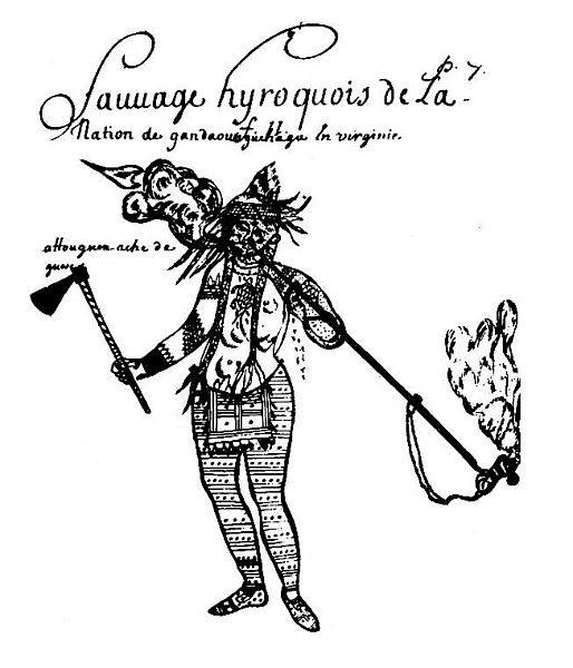
An Excerpt of the Notoway 
(Susquehanna - Seneca - Savana) Connection to the Nanticoke Moors adapted 
from Kenneth Clark at http://www.globalclassroom.org/clark.html


From increasing murders, land theft and other pressure, some members of the tribe (Nanticokes) moved over to the tribe's "summer residence" on the Indian River in Maryland; which became under the control of William Penn after the mason-dixon settlement.Ca. 1742 the tribe under the influence of the Shawnee (Savana Indians) officially petitioned Penn and the Susquehannocks for permission to relocate into the Susquehanna valley due to the rude treatment at the hands of Maryland colonists, which was granted. Many of the Tribe relocated to the Susquehanna, under the protection of the Iroquois (Seneca). 

During the Revolutionary War, the Nanticokes joined the intertribal Chickamauga forces and fought on the side of the British; and subsequently became persona non grata in the US afterwards. The tribe then split, some going into Canada,others joined the Six Nations Reservation, while others returned to the swamps along the Indian River . However, there were those who went to South Carolina to join relatives near the Chickasaw reservation, but unfortunately those lands were confiscated also by the new United States government because of the tribe's British alliance during the war. The Canada Nanticokes were subsumed into the Canada Iroquois. The Delaware Nanticokes have remained, and held onto their identity, throughout this persecution and exodus. 

The  Notowegans today are an amalgamation of the above tribes and carry some of the surnames associated with the Nanticoke Community i.e.Bumberry, Burke, Burton, Clark, Cormeans, Coursey, Davis, Drain, Hansor, Harmon, Hill, Jackson, Johnson, Kimmey, Layton, Miller, Morris, *Moseley, Newton, Norwood, Reed, Ridgeway, Rogers Sockum, Street, Thomas, Thompson, Walker and Wright. 

*The Moseley family in South Carolina had married into the Moor and Reed families and were connected to the Moors as well as Indians. 

(see the gilbert link on the tribal enrollment page). 
 

Andastes - Susquehannock - Notoweega - Mingo's


The Susquehannas, Minquas, or Conestogas

The Susquehannas is the general term applied to the Indians living on both sides of the Susquehanna River and its tributaries, in Pennsylvania, at the beginning of the historic period. Racially and linguistically, they were of Iroquoian stock, but were never taken into the league of the Iroquois, except as subjects. These related tribes were known by various names. Captain John Smith, the Virginia pioneer, who met them while exploring Chesapeake Bay and its tributaries in 1608, called them the "Susquehannocks." The French called them the Andastes, while the Dutch and Swedes called them Minquas. In the latter days of their history as a tribe, they were called the Conestogas. To Captain John Smith, of the Colony of Virginia, belongs the distinction of being the first white man to see the Indians of Pennsylvania, though he never set foot on Pennsylvania soil; and the Indians meeting him and his companions, beheld for the first time the race that was coming to drive them from their streams and hunting grounds. These Indians were the Susquehannas. Smith held a conference with sixty of the Susquehannocks, near the head of Chesapeake Bay, about August 1, 1608, as he and twelve companions were making an exploring expedition. The sixty Susquehannocks had come from one of their principal towns in what is now Lancaster County, Penn- sylvania. Smith gives the following interesting description of these Indians:

"Such great and well proportioned men are seldom seen, for they seemed like giants to the English, yea, and to their neighbors, yet seemed of an honest and simple disposition. They were with much ado restrained from adoring us as gods. These are the strangest people of all these countries, both in language and attire; for their language it may well become their proportions, sounding from them as a voice in the vault. Their attire is the skins of bears and wolves; some have cossacks made of bears' heads and skins, that a man's head goes through the skin's neck, and the ears of the bear fastened to his shoulders, the nose and teeth hanging down his breast, another bear's face split behind him, and at the end of the nose hung a paw, the half sleeves coming to the elbows were the necks of bears, and the arms through the mouth with paws hanging at their noses. One had the head of a wolfe hanging in a chain for a jewel, his tobacco pipe three quarters of a yard long, prettily carved with a bird, a deer, or some such device at the great end, sufficient to beat out one's brains; with bows, arrows, and clubs, suitable to their greatness. Five of their chief Werowances came aboard us and crossed the bay in the barge. The picture of the greatest of them is signified in the map. The calf of whose leg was three-quarters of a yard about, and all the rest of his limbs so answerable to that proportion that he seemed the goodliest man we ever beheld. His hair, the one side was long, the other shorn close with a ridge over his crown like a cock's comb. His arrows were five quarters long, headed with the splinters of a white christall-like stone, in form of a heart, an inch broad, an inch and a half or more long. These he wore in a wolf's skin at his back for his quiver, his bow in the one hand and his club in the other, as is described."

Smith goes on to say that these Susquehannas were scarce known to Powhatan, the great Virginia chief, but that they were a powerful tribe living in palisaded towns to defend them from the Massawomeks, or Iroquois, and having six hundred warriors. During the ceremonies connected with the visit of this band of Susquehannas, Smith says that they first sang "a most fearful song," and then, "with a most strange, furious action and a hellish voice began an oration." When the oration was ended, they decorated Smith with a chain of large white beads, and laid presents of skins and arrows at his feet, meanwhile stroking their hands about his neck. They told him about their enemies, the Iroquois, who, they said, lived beyond the mountains far to the north and received their hatchets and other weapons from the French in Canada. They implored Smith to remain with them as their protector, which, of course, he could not do. "We left them at Tockwogh," he says, "sorrowing for our departure." Smith's account of the large stature of the Susquehannas has 30 THE INDIAN WARS OF PENNSYLVANIA been corroborated by subsequent discoveries, when burying grounds of this tribe, in Lancaster County, were opened and very large human skeletons found. The Susquehannas, in the early part of the seventeenth cen-tury, carried on war with the "River Indians," as the Delawares, or Lenape then living along the Delaware River, were called. The Susquehannas were friendly with both the Swedes and the Dutch, and shortly after the Swedes arrived on the Delaware in 1638, they sold part of their lands to them. The Swedes equipped these Indians with guns, and trained their warriors in European tactics. When the Hurons were being worsted by the Iroquois in 1647, the Susquehannas offered the friendly Hurons military assistance, "backed by 1300 warriors in a single palisaded town, who had been trained by Swedish soldiers." They were also friendly with the colony of Maryland in the early days of its history, selling part of their lands to the Marylanders, and receiving military supplies from them.

"The Indian wars of Pennsylvania : an account of the Indian events, in Pennsylvania, of the French and Indian war, Pontiac's war, Lord Dunmore's war, the revolutionary war, and the Indian uprising from 1789 to 1795 ; tragedies of the Pennsylvania frontier based primarily on the Penna. archives and colonial records / by C. Hale Sipe ; introduction by Dr. George P. Donehoo"


Excerpts from John Swanton concerning... 

The Yamassee and the Yuchi of the Savanah River Yamasee. 
 

Meaning unknown, though it has been interpreted by Muskogee yamasi, "gentle." The form given in some early writings, Yamiscaron, may have been derived from a Siouan dialect or from 
Timucua. 

Connections.- The Yamasee town and chief names indicate plainly that they spoke a Muskhogean dialect and tradition affirms that it was connected most closely with Hitchiti, a contention which may be considered probable. 

Location.- The earliest references that we have place the Yamasee on Ocmulgee River not far above its junction with the Oconee. They seem to have ranged or extended northeastward of these rivers to or even slightly beyond the Savannah, but always inland. (See also Florida, Alabama, South Carolina.) 

Subdivisions and Villages 

Immediately before the outbreak of the Yamasee War there were the following: 

Upper Towns: 

Huspaw, near Huspaw Creek between Combahee River and the 
Whale Branch. 
Pocotaligo, near Pocotaligo River. 
Sadkeche, probably near Salkehatchie, a hamlet at the 
Atlantic Coast Line crossing of the Combahee River. 
Tomatly, in the neighborhood of Tomatly, Beaufort County, S.C. 
Yoa, near Huspaw. 

Lower Towns: 

Altamaha, location unknown. 
Chasee, location unknown. 
Oketee, probably near one of the places so called on New 
River, in Jasper and 
Beaufort Counties, S.C. 
Poeasabo. 
Tulafina (?), perhaps near Tulsfinny Creek, an estuary of 
the Coosawhatchie River in Jasper County. 

Other possible Yamasee settlements were Dawfuskee, Ilcombe, and Peterba. 

History.- The first reference to the Yamasee appears to be a mention of their name in the form Yamiscaron as that of a province with which Francisco of Chicora was acquainted in 1521. The "Province of Altamaha" mentioned by De Soto's chronicler Ranjel in 1540 probably included at least a part of the Yamasee people. For a hundred years afterward the tribe remained practically unnoticed except for a brief visit by a Spanish soldier and two missionaries in 1597, but in 1633 they are reported to have asked for missionaries, and in 1639 peace is said to have been made between the allied Chatot, Lower Creeks, and Yamasee and the Apalachee. In 1675 Bishop Calderon of Cuba founded two missions in the Apalachee country which were occupied by Yamasee or their near relatives. The same year there were three Yamasee missions on the Atlantic coast but one of these may have been occupied by Tamathli. Later they moved nearer St. Augustine but in the winter of 1684-85 some act of the Spanish governor offended them and they removed to South Carolina, where the English gave them lands on the west side of Savannah River near its mouth. Some of these Indians were probably from the old Guale province, but the Yamasee now took the lead. Eighty-seven warriors of this nation took part in Barnwell's expedition against the Tuscarora (see North Carolina). In 1715 they rose in rebellion against the English and killed two or three hundred settlers but were defeated by Governor Craven and took refuge in Florida, where, until the cession of Florida to Great Britain. the Yamasee continued as allies of the Spaniards. Meanwhile their numbers fell off steadily. Some remained in the neighborhood of the St. Johns River until the outbreak of the Seminole War. 

The Oklawaha band of Seminole is said to have been descended from them. Another band accompanied the Apalachee to Pensacola and Mobile, and we find them located near those two places on various charts. They may be identical with those who, shortly afterward, appear among the Upper Creeks on certain maps, though this is the only testimony we have of their presence there. At any rate, these latter are probably the Yamasee found among the Lower Creeks in the nineteenth century and last heard of among the Seminole of west Florida. Of some historical importance is a small band of these Indians who seem to have lived with the Apalachicola for a time, after the Yamasee War, and in 1730 settled on the site of what is now Savannah under the name of Yamacraw. There the Georgia colonists found them three years later, and the relations between the two peoples were most amicable. The name Yamacraw was probably derived from that of a Florida mission, Nombre de Dios de Amacarisse, where some of the Yamnsee once lived. Ultimately these Yamacraw are believed to have retired among the Creeks and later may have gone to Florida. 

Population.- It is impossible to separate distinctly the true Yamasee from the Guale Indians. Mooney (1928) gives an estimate of 2,000 in 1650, probably too low. A mission list compiled by Gov. Salazar of Florida in 1675 gives 1,190 Yamasee and Tama. In 1708 the two tribes, united under the name Yamasee, were thought to have 500 men capable of bearing arms. In 1715 a rather careful census gives 413 men and a total population of 1,215. Lists dating from 1726 and 1728 give 313 and 144 respectively in the missions about St. Augustine. A fairly satisfactory Spanish census, taken in 1736, indicates that there were then in the neighborhood of St. Augustine more than 360 Yamasee and Indians of Guale. This does not include the Yamasee near Pensacola and Mobile, those in the Creek Nation, or the Yamacraw. In 1761 a body of Yamasee containing 20 men was living near St. Augustine, but by that time the tribe had probably scattered widely. In 1821 the "Emusas" on Chattahoochee River numbered 20 souls. 

Connection in which they have become noted.- The Yamasee are famous particularly on account of the Yamasee War, which marked an epoch in Indian and White history in the Southeast. At the end of the seventeenth century a certain stroke was used in paddling canoes along the coast of Georgia, South Carolina, and Florida, which was called the "Yamasee stroke." A small town in Beaufort County, S. C., is called "Yemasee," a variant of this name. 

Yuch. Significance unknown, but perhaps, as suggested by Speck (1909), from a native word meaning "those far away," or "at a distance," though it is also possible that it is a variant of Ochesee or Ocheese, which was applied by the Hitchiti and their allies to Indians speaking languages different from their own. Also called: 

Ani'-Yu'tsi, Cherokee name. 
Chiska, probably a Muskogee translation of the name of one of their bands. 
 

Hughchee, an early synonym. 
Round town people, a name given by the early English colonists. 
 

Rickohockans, signifying "cavelanders" (Hewitt, in Hodge, 1907), perhaps an early name for a part of them. 
 

Tahogalewi, abbreviated to Hogologe, name given them by the Delaware and other Algonquian people. 
 

Tamahita, so called by some Indians, perhaps some of the eastern Siouans. 
 

Tsoyaha, "People of the sun," their own name, or at least the name of one band. 
 

Westo, perhaps a name applied to them by the Cusabo Indians of South Carolina though the identification is not beyond 
question. 

Connections.- The Yuchi constituted a linguistic stock, the Uchean, distinct from all others, though structurally their 
speech bears a certain resemblance to the languages of the Muskhogean and Siouan families. 

Location.- The earliest known location of the Yuchi was in eastern Tennessee, perhaps near Manchester, but some of them 
extended still farther east, while others were as far west as Muscle Shoals. On archeological grounds Prof. T. M. N. Lewis 
believes that one main center of the Yuchi was on Hiwassee River. We find settlements laid down on the maps as far north as Green River, Kentucky. In later times a part settled in West Florida, near the present Eucheeanna, and another part on Savannah and Ogeechee Rivers. (See also Alabama, Florida, Oklahoma, Tennessee, and South Carolina.) 

Subdivisions 

There appear to have been three principal bands in historic times: one on Tennessee River, one in West Florida, and one on 
Savannah River, but only a suggestion of native band names has survived. Recently Wagner has heard of at least three 
subdivisional names, including the Tsoyaha, or "Sun People" and the Root People. 

Villages 

Most of their settlements are given the name of the tribe, Yuchi, or one of its synonyms. In early times they occupied a town in eastern Tennessee called by the Cherokee Tsistu'yl, "Rabbit place," on the north bank of Hiwassee River at the entrance of Chestua Creek in Polk County, Tenn., and at one time also that of Hiwassee, or Euphasee, at the Savannah Ford of Hiwassee River. The Savannah River band had villages at Mount Pleasant, probably in Screven County, Ga., near the mouth of Brier Creek, 2 miles below Silver Bluff on Savannah River in Barnwell County; and one on Ogeechee River bearing the name of that stream, though that was itself perhaps one form of the name Yuchi. Hawkins (1848) mentions former villages at Ponpon and Saltketchers in South Carolina, but these probably belonged to the Yamasee. The following Yuchi settlements were established after the tribe united with the Lower Creeks: 

Arkansaw River, in Oklahoma. 

Big Pond Town, Polecat Creek, and Sand Creek, in and near Creek County, Okla. 

Blackjack Town. 

Deep Fork Creek, Okla. 

Duck Creek Town. 

Intatchkalgi, on Opilthlako Creek 28 miles above its junction with Flint River, probably in Schley County, Ga. 

Padshilaika, at the junction of Patchilaika Creek with Flint River, Macon County, Ga. 

Red Fork, location uncertain. 

Snake Creek, location uncertain. 

Spring Garden Town, above Lake George, Fla. 

Tokogalgi, on Kinchafoonee Creek, an affluent of Flint River, Ga. 

History.- The chroniclers of the De Soto expedition mention the Yuchi under the name Chisca, at one or more points in what is now Tennessee. In 1567 Boyano, an officer under Juan Pardo, had two desperate encounters with these Indians somewhere in the highlands of Tennessee or North Carolina, and, according to his own story, destroyed great numbers of them. In 1670 Lederer (1912) heard of people called Rickohockans living in the mountains who may have been Yuchi, and two white men sent from Virginia by Abraham Wood visited a Yuchi town on a head stream of the Tennessee in 1674. About this time also, English explorers and settlers in South Carolina were told of a warlike tribe called Westo (probably a division of Yuchi) who had struck terror into all of the coast Indians, and hostilities later broke out between them and the colonists. At this juncture, however, a band of Shawnee made war upon the Westo and drove them from the Savannah. For a time they seem to have given themselves up to a roving life, and some of them went so far inland that they encountered La Salle and settled near Fort St. Louis, near the present Utica, Ill. Later some were located among the Creeks on Ocmulgee River, and they removed with them to the Chattahoochee in 1715. Another band of Yuchi came to live on Savannah River about 20 miles above Augusta, probably after the expulsion of the Westo. They were often called Hogologe. In 1716 they also moved to the Chattahoochee but for a time occupied a town distinct from that of the other Yuchi. It was probably this band which settled near the Shawnee on Tallapoosa River and finally united with them. Still later occurred a third influx of Yuchi who occupied the Savannah between Silver Bluff and Ebenezer Creek. In 1729 a Kasihta chief named Captain Ellick married three Yuchi women and persuaded some of the Yuchi Indians to move over among the Lower Creeks, but Governor Oglethorpe of Georgia guaranteed them their rights to their old land until after 1740, and the final removal did not, in fact, take place until 1751. 

A still earlier invasion of southern territories by Yuchi is noted by one of the governors of Florida in a letter dated 1639. These invaders proved a constant source of annoyance to the Spaniards. Finally they established themselves in West Florida not far from the Choctawhatchee River, where they were attacked by an allied Spanish and Apalachee expedition in 1677 and suffered severely. They continued to live in the same region, however, until some time before 1761 when they moved to the Upper Creeks and settled near the Tukabahchee. Eucheeanna in Walton County, Fla. seems to preserve their name. 

A certain number of Yuchi remained in the neighborhood of Tennessee River, and at one time they were about Muscle Shoals. They also occupied a town in the Cherokee country, called by the latter tribe Tsistu'yl, and Hiwassee at Savannah Ford. In 1714, the former was cut off by the Cherokee in revenge for the murder of a member of their tribe, instigated by two English traders. Later tradition affirms that the surviving Yuchi fled to Florida, but many of them certainly remained in the Cherokee country for a long time afterward, and probably eventually migrated west with their hosts. 

A small band of Yuchi joined the Seminole just before the outbreak of the Seminole War. They appear first in West Florida, near the Mikasuki but later had a town at Spring Garden in Volusia County. Their presence is indicated down to the end of the war in the Peninsula, when they appear to have gone west, probably reuniting with the remainder of the tribe. 

The Yuchi who stayed with the Creeks accompanied them west and settled in one body in the northwestern part of the old Creek Nation, in Creek County, Okla. 

Population.- For the year 1650 Mooney (1928) makes an estimate of 1,500 for the Yuchi in Georgia, Alabama, and Tennessee, but this does not include the "Westo," for whom, with the Stono, he allows 1,600. The colonial census of 1715 gives 2 Yuchi towns with 130 men and 400 souls, but this probably takes into consideration only I band out of 3 or 4. In 1730 the band still on Tennessee River was supposed to contain about 150 men. In 1760, 50 men are reported in the Lower Creek town and 15 in one among the Upper Creeks. In 1777 Bartram (1792) estimated the number of Yuchi warriors in the lower town at 500 and their total population as between 1,000 and 1,500. In 1792 Marburg (1792) reports 300 men, or a population of over 1,000, and Hawkins in 1799 says the Lower Creek Yuchi claimed 250 men. According to the census of 1832-33 there were 1,139 in 2 towns known to have been occupied by Indians of this connection. In 1909 Speck stated that the whole number of Yuchi could "hardly exceed five hundred," but the official report for 1910 gives only 78. That, however, must have been an underestimate as the census of 1930 reported 216. Owing to the number of Yuchi bands, their frequent changes in location, and the various terms applied to them, an exact estimate of their numbers at any period is very difficult. In the first half of the sixteenth century they may well have numbered more than 5,000. 

Connection in which they have become noted.- The Yuchi have attained an altogether false reputation as the supposed aborigines of the Gulf region. They were also noted for the uniqueness of their language among the Southeastern tongues. The name is preserved in Euchee, a posthamlet of Meigs County, Tenn.; Eucheeanna, a post village of Walton County, Fla.; Euchee (or Uchee) Creek, Russell County, Ala.; Uchee, a post station of Russell County, Ala.; Uchee Creek, Columbia County, Ga.; and an island in Savannah River near the mouth of the latter. 

*The Chickasaw and Chickamauga Creek Amalgamation

The Chickasaws who had settled on both sides of the Savanah at Horse Creek just above Fort Moore and opposite the former Fort Augusta were exiled from the Chickasaw Nation. This particular band along with the"Breed Camp" band, who had a town among the Upper Creeks known as Ooe-asa in Alabama were "outlawed" by the Chickasaw Nation. Originally they were one band that had detached themselves from the Chickasaw Nation, because they had become allies of the British and not the French. Even though there was geographic distance between the two exiled bands, they were continually in alliance with each other. Chief Jocky was the head chief of the Breed Camp band and in 1722 the Squirrel King, a.k.a. Mingo Tunni, (he had a sister among the Yamassee) was chief of the Savanah Band. From 1723 to Ca. 1783, the Chickasaws lived on the Savanah River opposite Augusta, Ga. In 1739, a 22,774 acres reservation was granted to our people in the vicinity of the "old Savanah Town," under the protection of the British garrison at Fort Moore in present day Aiken Co. 

Forty Chickasaw families settled on the reservation to serve the purpose of protecting British pack trains against the French Indian allies north of the Ohio River. Captain John Reed (We-A-Se-Sa-Ka), a Savanah Indian was among the above pack horsemen. The Chickasaw reservation also extended into Georgia near Fort Augusta. The Georgia portion of reservation lands consisted of ten by ten miles was extended to the tribe for their contribution as valuable and expert scouts for the British army under Oglethorpe, against the Spanish in Florida during the Jenkins Ear War (1739-48). The exciled band of Chickasaws remained on the reservation until our lands were confiscated in 1783, because we had assisted the British in defending Pensacola against the Spanish around the Revolutionary War period. Most of the Exciled Chickasaws left the Savanah area to unite with the Chickasaws who were at Ooe-asa with the Alabama Creeks. However thirty Chickasaw men remained with their intertribal families near their old territory in the proximity of Fort Moore and Fort Augusta.

Edmond Atkin, the Royal British Superintendent of Indian Affairs who was a member of the Council, which had allotted the above reservation to the Savanah Band of Chickasaws stated in 1754 that.... "Their chief connection is with the Lower Creeks (Yamassee), with whom they had always preserved a friendship; and some of them had taken wives among the Lower Cherokees (Chickamauga)....." George Bennet and Captain Reed a.k.a. We-A-Se-Sa-Ka ( his Savanah name), were packhorsemen for Edmund Atkin. Both men were descended from the Chowanoc (Shawano) a.k.a. Savana Indian head chiefs who were residing on Shawano reservation lands held formerly in Gates Co. N.C. as stated in the following reference: James Bennett, Thos Hoyter (Hite, Hiter), Charles Beasley, Jeremiah Pushin, John Robins, John Reading (John Read) & Nuce Will Chief men of the Chowan Indians... [Chowan DeedBook W:250] (FREE AFRICAN AMERICANS by Paul Heinegg)

**In ca.1791 John Reed's son, John Jr. was christened in the same church, the Independent or Congregational Church, where Edmond Atkin owned a pew ca. 1750's. Edmund Atkin also engaged his packhorsemen inclusive of Captain John Reed and George Bennet in preventing goods of British origin from reaching those Chickasaws who were allies of the French. Regretfully, like many Indians and other Free People of Color of his era, John Reed was a slave holder and was listed on the Chickasaw Freedmen Rolls as being the owner of Sarah Reed born ca. 1828, on roll no. 3868. 

An Excerpt From Indians of the Southeastern U.S. by John R. Swanton

Nottoway (Notowega, Nittaweega, or Nautaugue) "Notowega,"Nittaweega," or "Nautaugue," was given to a band of Indians which appeared on the frontiers of S.C. in the eighteenth century. It is possible that this body of Indians is intended by the "Andasses or Iroquois" mentioned in a French document, attributed to the third decade of that century, in association with some Shawnee (Savanah/Shawanoc)and Chickasaw, as living 70 leagues below the Kaskinampo on Tennessee River. 

An Excerpt From Red Carolinians by C.J.  Milling - Chapter 4 -The Savanah 

The exact identity of the Notowega has been somewhat of a puzzle to S.C. historians, but the preamble to their "talk" to Gov. Glen, written soon after their arrival, suggest that they were a mixed band of Iroquois, Savanah, and Conestogah. This Document is titled " The Talk and Representation of Asaquah, the Head beloved Man of Nautaugue, Connewawtenty of Connetstageh and about Sixty others of different Towns of the Nitiwaga Nation of Indians now in Keowee in the Cherokees." 


NOTE: What follows is an  abstract from INDIAN TERRITORY: Descriptive Biographical and Genealogical, Including the Landed Estates, Country Seats, Etc., Etc., by D. C. Gideon, published 1901 by The Lewis Publishing Company, New York and Chicago. Generally, the content of this article was accurate with a few exceptions. KMA. 

THE CHOCTAWS AND CHICKASAWS

From the fact that these tribes seem to have a common origin and to have been originally one people, with the same customs and modes of living, and inhabiting the same section of country, the early history of one tribe finds its counterpart in the other. 

The traditional history of these tribes, the Choctaw signifying separation and the Chickasaw rebellion goes to show that both were members of the Muskogee nation prior to their migration to the country east of the Mississippi; and the tradition further states that two brothers, Chatah and Chicksah, both influential chiefs, headed the migration that is supposed to have started from western Mexico. Adair, in his American Indians, says that the Choctaws and Chickasaws descended from a people called Chickamacaws (Chickamaugas) , who were among the first inhabitants of the Mexican empire and at an early period wandered east with another tribe called Chockamaws. It may be easily inferred that the name Choctaw has its derivation from Chockamaws, and Chickasaw from Chickamacaws. It may be easily inferred that the name Choctaw has its derivation from Chockamaws, and Chickasaw from Chickamacaws ( a variant of Chickamauga).

Missionaries to these tribes as early as 1820 give their traditional history as related to them of the origin of the Choctaws and Chickasaws. Long years ago their ancestors lived in a country far toward the setting sun, and another great and powerful people greatly oppressed them (these are supposed to be the Spaniards under Cortez), and they decided to seek a country far removed from oppression; consequently a great council was called and after many days spent in deliberation it was decided that the whole people should leave on a given day and seek new homes, they knew not where. 

The two brothers, Chatah and Chicksah, had been previously selected to lead them, and the brothers, trusting all to chance, firmly placed a pole in the center of their encampment and decided to move the next day in the direction it leaned the following morning. Their medicine men and prophets, after many days of fasting and supplication, to whom the "Great Spirit" had revealed the direction the pole would lean on the following morning, were ready, and without hesitation the journey was begun, as the pole inclined to the east. The pole was set up every night alternately by the two chiefs and brothers. 

For weeks and months they journeyed through a country abounding in game, and yet the pole was found leaning to the east every morning, which indicated that their journey was not yet complete. For months more they moved on until they reached the greatest body of water ever known. This they named Misha Sapokni, meaning beyond age, whose source and terminus are unknown. But their talismanic pole still pointed eastward, and without a murmur the Indians set about building canoes and rafts, and in a few weeks all had been safely landed on the eastern bank of the Mississippi, and their eastward march was resumed until the bank of the Yazoo river was reached, when behold! the pole stood erect in the morning as when planted at night. The overjoyed messengers that observed this rushed through the encampment shouting "Fohah-hupishno-yak," by translation, "Rest we all of us here." 

Their weary pilgrimage was ended, and in commemoration of that great event they made into a mound three acres of land forty feet high, with a hole in the center ten feet in diameter, and enclosed the mound by a deep ditch encompassing twenty acres. After this was completed it was discovered to lean a little, and it was named Nunih Wai-zah. This relic still remains, but is great disfigured by the hand of time.

The tradition further informs us that Chatah and Chicksah, in their capacity as chieftains, disagreed on some national question, and Chicksah proposed to divide the people. This was agreed upon and a game of chance was resorted to by which the country was to be divided. A pole was set up and facing each other the brothers held it firmly with both hands. At a given signal both were to let go, and the direction the pole fell decided the direction Chicksah was to take. The result of the game was that Chicksah and his followers were to have the northern part of the country, and from that date they became two separate and distinct tribes, each of whom ever afterward retained the names of their respective chiefs. 

The traditions of the Choctaws and Chickasaws all point toward the time that their ancestors came from a country beyond the "Big Waters" far to the northwest; and the Muskogees, Shawnees, Cherokees and other tribes have the same traditions, that point beyond Behring straits, to Asia, as the land from which their forefathers came in past ages. Truly their legends, romances and exploits would form, if but known, a literature of themselves about whom still cluster that wonderful system of mythical romance which has assumed so many phases. They owned this vast continent and had possessed it for ages. 

De Soto was the first white man to invade the domain of the Choctaws and Chickasaws, in October 1540. He had a force of one hundred cavalry, and as many infantry. Mobila, or Mobile, was the Choctaw capital, and at that time it contained eighty houses, each being large enough to contain a thousand men. All these houses stood fronting a large square, and the entire town was surrounded by a high wall made of trees firmly set in the ground and strengthened with cross timbers fastened together with great vines. Towers, fifteen feet apart, that would hold eight men each, spanned the enclosure, and two gates, one on the east, the other on the west, afforded ingress and egress. 

Tush-ka-lusa, then the chief of the Choctaws, welcomed the approach of De Soto into his village with songs and dancing of beautiful Indian girls, and De Soto's retinue were given seats under a canopy expressly provided. A son of the chief had previously visited De Soto with an invitation to visit his father, and he was held as a prisoner until this visit was made. After they had all remained seated for a time, Tush-ka-lusa asked that he be released, but to this request De Soto paid no attention, and Tush-ka-lusa indignantly arose and walked away to where a group of his warriors stood. De Soto felt much annoyed at this proof of independence on the part of the chief, and at once sent a man to invite Tush-ka-lusa to breakfast with him; but the chief refused to return, and directed the man to inform De Soto that "he had better take his troops and get out of my territory." De Soto gave word to his men to be prepared for an attack, but, being desirous of securing the chief, advanced toward him extending his hand; but this was declined by Tush-ka-lusa, who turned his back and was soon lost among his warriors. Just then a warrior ran out of the house denouncing the Spaniards as robbers and murderers, and declared that they should not longer hold their chief's son as a prisoner, when a Spaniard with one sweep of his sword cut him in two. The Choctaws, beholding the death of their comrade, with a defiant war whoop rushed upon De Soto and his men, and for three long hours the battle raged, first one, then the other securing the advantage; but the white soldiers, protected by coats of mail, hewed down the gates and rushing through the breach assailed the Choctaws and a fearful carnage ensued. For nine hours the hand-to-hand conflict raged, and it is estimated by Garcellasso, one of De Soto's men, that over six thousand were killed inside and outside of the town! The houses were set on fire and Mobila was left in ruins. Tush-ka-lusa perished with his people, who could not with bow and arrow cope with broadsword and buckler wielded by a trained Spaniard soldier clad in a suit of mail. In this battle eighty-two Spaniards and forty-five horses were killed. After the destruction of Mobila, De Soto and his band remained for several days around the ruins of the destroyed village, gathering up a large number of beautiful Indian girls which were taken into captivity and carried away. 

There remains no doubt that the Mobilians, as described by early writers, were Choctaws, and they also state that the Choctaws and the "Hottak falaiahs" (or long men) spoke the same language. The present city of Mobile, Alabama, was named after the "Iksa" or Mobina clan of Choctaws, by Bienville. The aged Choctaws now living assert that originally their people were divided into two great "lksas," or clans, the first of which was known as "Hattak-i-hol-lihtah," the other "Kashapa-okla." The two were subsequently divided into six clans, named as follows: Hayip-tuk-lo-hash (the two lakes), Hattack-falaih-hosh (the long men), Okla-humali-hosh (the six people), Kusha (being broken), Apela (a help), and Chik-a-saw-ha (a Chickasaw). 

The laws of all these clans forbade marriage between people belonging to the same clan, and to this day the same laws relating to marriage are strictly observed.  

Tradition informs us that there were many wars between the Choctaws and Chickasaws for a period of more than one hundred years, during which time the Choctaws were mainly victorious; but the wars thinned the ranks of both, of their best and bravest warriors. 

On the 13th of January 1733, the renowned Christian philanthropist, James Oglethorpe, with a hundred and twenty emigrants, landed at Charleston, South Carolina. A few days later he sailed down the coast and anchored his vessel at Beaufort, while he, accompanied by a few of his people, ascended the Savannah river to the point where the city of Savannah is now located, which place he selected as a desirable one to establish his colony. Tam-o-chi-chi, the great chief of the Yemacaws (a band of Yamassee Indians, on the Savanah River), made Oglethorpe a visit after a few days, and they smoked the pipe of peace together. The friendship then formed was never broken. The Yemacaws(a.k.a.Yamacraw) were supposedly a branch of the Choctaws, from the similarity of their language, habits and customs. When the venerable chief was ready to depart he presented Oglethorpe with a great buffalo robe, upon which was painted with great skill the picture of an eagle. Tam-o-chi-chi, handing the robe to Oglethorpe, called his attention to the picture of the eagle and said, "Accept this little token of good will of myself and people. See, the eagle is bold and fearless, yet his feathers are soft. As the eagle, so are my people, bold and fearless in war; yet, as his feathers, so are they soft and beautiful in friendship. The buffalo is strong and his hair is warm. As the buffalo, so is my people strong in war, yet as his robe, are they warm in love. Let this robe be an emblem of peace and love between me and you, mine and thine." 

On the 29th of May following, Oglethorpe held a council with the Muskogees at Savannah, at which Long Chief, of the Ocona clan, with all their allies was present, and in token of peace and friendship Oglethorpe was presented with many large bundles of skins and furs of wild animals with which their country then abounded. 

In 1777 the Choctaws sold to the English superintendent of Indian affairs a portion of their territory, known as the Natchez district, that lay on the Mississippi river and extended north from the bluff known as Loftus Cliffs to the mouth of the Yazoo river one hundred and ten miles above. Their territory in 1771 extended from middle Mississippi south to the gulf of Mexico, and from the Alabama river west to the Mississippi river. 

The first treaty made between the Choctaws and the United States was held at Hopewell, on the Keowee river, January 3, 1786, followed by several other treaties, among which was the cession of most of their lands lying east of the Mississippi river, and in one, the treaty concluded October 18, 1820, in article 5th, for the purpose of aiding the poor Indians who wish to remove to the then unknown country, which they had purchased west of the Mississippi, the commissioners of the United States agreed to give to each war-riot "a blanket, kettle, rifle, bullet-mold, nippers and ammunition sufficient to last for one year;" and each warrior was also assured of having corn enough to support him and his family for the same time and whilst traveling to the country ceded the Choctaw nation. This magnanimous offer was given by the United States to secure the "happiness and protection, and to promote the civilization, of the Choctaw Indian." 

TREATY WITH THE CHICKASAWS-- 1786 

Articles of a treaty, concluded at Hopewell, on the Keowe'e, near Seneca Old Town, between Benjamin Hawkins, Andrew Pickens, and Joseph Martin, Commissioners Plenipotentiary of the United States of America, of the one Part; and Piomingo, Head Warrior and First Minister of the Chickasaw Nation; Mingatushka, one of the leading Chiefs; and Latopoia, first beloved Man of the said Nation, Commissioners Plenipotentiary of all the Chickasaws, of the other Part. 

THE Commissioners Plenipotentiary of the United States of America give peace to the Chickasaw Nation, and receive them into the favor and protection of the said States, on the following conditions:  

ARTICLE 1. The Commissioners Plenipotentiary of the Chickasaw nation, shall restore all the prisoners, citizens of the United States, to their entire liberty, if any there be in the Chickasaw nation. They shall also restore all the negroes, and all other property taken during the late war, from the citizens, if any there be in the Chickasaw nation, to such person, and at such time and place, as the Commissioners of the United States of America shall appoint. 

ARTICLE 2. The Commissioners Plenipotentiary of the Chickasaws, do hereby acknowledge the tribes and the towns of the Chickasaw nation, to be under the protection of the United States of America, and of no other sovereign whosoever.  

ARTICLE 3. The boundary of the lands hereby allotted to the Chickasaw nation to live and hunt on, within the limits of the United States of America, is, and shall be the following, viz: Beginning on the ridge that divides the waters running into the Cumberland, from those running into the Tennessee, at a point in a line to be run north-east, which shall strike the Tennessee at the mouth of Duck river; thence running westerly along the said ridge, till it shall strike the Ohio; thence down the southern banks thereof to the Mississippi; thence down the same, to the Choctaw line or Natches district; thence along the said line, or the line of the district eastwardly as far as the Chickasaws claimed, and lived and hunted on, the twenty-ninth of November, one thousand seven hundred and eighty-two. Thence the said boundary, eastwardly, shall be the lands allotted to the Choctaws and Cherokees to live and hunt on, and the lands at present in the possession of the Creeks; saving and reserving for the establishment of a trading post, a tract or parcel of land to be laid out at the lower port of the Muscle shoals, at the mouth of Ocochappo, in a circle, the diameter of which shall be five miles on the river, which post, and the lands annexed thereto, shall be to the use and under the government of the United States of America. 
 
ARTICLE 4. If any citizen of the United States, or other person not being an Indian, shall attempt to settle on any of the lands hereby allotted to the Chickasaws to live and hunt on, such person shall forfeit the protection of the United States of America, and the Chickasaws may punish him or not as they please. 
 
ARTICLE 5. If any Indian or Indians, or persons residing among them, or who shall take refuge in their nation, shall commit a robbery or murder, or other capital crime, on any citizen of the United States, or person under their protection, the tribe to which such offender or offenders may belong, or the nation, shall be bound to deliver him or them up to be punished according to the ordinances of the United States in Congress assembled: Provided, that the punishment shall not be greater, than if the robbery or murder, or other capital crime, had been committed by a citizen on a citizen. 
 
ARTICLE 6. If any citizen of the United States of America, or person under their protection, shall commit a robbery or murder, or other capital crime, on any Indian, such offender or offenders shall be punished in the same manner as if the robbery or murder or other capital crime had been committed on a citizen of the United States of America; and the punishment shall be in presence of some of the Chickasaws, if any will attend at the time and place, and that they may have an opportunity so to do, due notice, if practicable, of such intended punishment, shall be sent to some one of the tribes. 
 
ARTICLE 7. It is understood that the punishment of the innocent under the idea of retaliation is unjust, and shall not be practiced on either side, except where there is a manifest violation of this treaty; and then it shall be preceded, first by a demand of justice, and if refused, then by a declaration of hostilities. 

ARTICLE 8. For the benefit and comfort of the Indians, and for the prevention of injuries or oppressions on the part of the citizens or Indians, the United States in Congress assembled shall have the sole and exclusive right of regulating the trade with the Indians, and managing all their affairs in such manner as they think proper. 

ARTICLE 9. Until the pleasure of Congress be known respecting the eighth article, all traders, citizens of the United States, shall have liberty to go to any of the tribes or towns of the Chickasaws to trade with them, and they shall be protected in their persons and property, and kindly treated. 

ARTICLE 10. The said Indians shall give notice to the citizens of the United States of America, of any designs which they may know or suspect to be formed in any neighboring tribe, or by any person whosoever, against the peace: trade or interests of the United States of America. 

ARTICLE 11. The hatchet shall be forever buried, and the peace given by the United States of America, and friendship re-established between the said States on the one part, and the Chickasaw nation on the other part, shall be universal, and the contracting parties shall use their utmost endeavors to maintain the peace given as aforesaid, and friendship re-established. 

In witness of all and every thing herein contained, between the said States and Chickasaws, we, their underwritten commissioners, by virtue of our full powers, have signed this definitive treaty, and have caused our seals to be hereunto affixed.  

Done at Hopewell, on the Keowee, this tenth day of January, in the year of our Lord one thousand seven hundred and eighty-six.  

Benjamin Hawkins,

And'w. Pickens,

Jos. Martin,

Piomingo, his x mark,

Mingatushka, his x mark,

Latopoia, his x mark,

Witness: 

Wm. Blount, 

Wm. Hazard, 

Sam. Taylor, 

James Cole, Sworn Interpreter. 


Treaty of New York - U.S. - Creek Treaty of New York, Aug. 7, 1790 

A Treaty of Peace and Friendship made and concluded between the President of the United States of America, on the Part and Behalf of the said States, and the undersigned Kings, Chiefs and Warriors of the Creek Nation of Indians, on the Part and Behalf of the said Nation. /A/ 

The parties being desirous of establishing permanent peace and friendship between there United States and the said Creek Nation, and the citizens and members thereof, and to remove the causes of war by ascertaining their limits, and making other necessary, just and friendly arrangements: The President of the United States, by Henry Knox, Secretary for the Department of War, whom he hath constituted with full powers for these purposes, by and with the advice and consent of the Senate of the United States, and the Creek Nation, by the undersigned Kings, Chiefs and Warriors, representing the said nation, have agreed to the following articles. 

ARTICLE I. 

There shall be perpetual peace and friendship between all the citizens of the United States of America, and all the individuals, towns and tribes of the Upper, Middle and Lower Creeks and Semanolies composing the Creek nation of Indians. /B/ 

ARTICLE II. 

The undersigned Kings, Chiefs and Warriors, for themselves and all parts of the Creek Nation within the limits of the United States, do acknowledge themselves, and the said parts of the Creek nation, to be under the protection of the United States of America, and of no other sovereign whosoever; and they also stipulate that the said Creek Nation will not hold any treaty with an individual State, or with individuals of any State. /C/

ARTICLE III. 

The Creek Nation shall deliver as soon as practicable to the commanding officer of the troops of the United States, stationed at the Rock-Landing on the Oconee river, all citizens of the United States, white inhabitants or negroes, who are now prisoners in any part of the said nation. And if any such prisoners or negroes should not be so delivered, on or before the first day of June ensuing, the governor of Georgia may empower three persons to repair to the said nation, in order to claim and receive such prisoners and negroes. /D/ 

ARTICLE IV. 

The boundary between the citizens of the United States and the Creek Nation is, and shall be, from where the old line strikes the river Savannah; thence up the said river to a place on the most northern branch of the same, commonly called the Keowee, where a north east line to be drawn from the top of the Occunna mountain shall intersect; thence along the said line in a south-west direction to Tugelo river; thence to the top of the Currahee mountain; thence to the head or source of the main south branch of the Oconee river, called the Appalachee; thence down the middle of the said main south branch and river Oconee, to its confluence with the Oakmulgee, which form the river Altamaha; and thence down the middle of the said Altamaha to the old line on the said river, and thence along the said old line to the river St. Mary's. /E/ 

And in order to preclude forever all disputes relatively to the head or source of the main south branch of the river Oconee, at the place where it shall be intersected by the line aforesaid, from the Currahee mountain, the same shall be ascertained by an able surveyor on the part of the United States, who shall be assisted by three old citizens of Georgia, who may be appointed by the Governor of the said state, and three old Creek chiefs, to be appointed by the said nation; and the said surveyor, citizens and chiefs shall assemble for this purpose, on the first day of October, one thousand seven hundred and ninety-one, at the Rock Landing on the said river Oconee, and thence proceed to ascertain the said head or source of the main south branch of the said river, at the place where it shall be intersected by the line aforesaid, to be drawn from the Currahee mountain. And in order that the said boundary shall be rendered distinct and well known, it shall be marked by a line of felled trees at least twenty feet wide, and the trees chopped on each side from the said Currahee mountain, to the head or source of the said main south branch of the Oconee river, and thence down the margin of the said main south branch and river Oconee for the distance of twenty miles, or as much farther as may be necessary to mark distinctly the said boundary. And in order to extinguish forever all claims of the Creek nation, or any part thereof, to any of the land lying to the northward and eastward of the boundary herein described, it is hereby agreed, in addition to the considerations heretofore made for the said land, that the United States will cause certain valuable Indian goods now in the state of Georgia, to be delivered to the said Creek nation; and the United States will also cause the sum of one thousand and five hundred dollars to be paid annually to the said Creek nation. And the undersigned Kings, Chiefs and Warriors, do hereby for themselves and the whole Creek nation, their heirs and descendants, for the considerations above-mentioned, release, quit claim, relinquish and cede, all the land to the northward and eastward of the boundary herein described. 

ARTICLE V. 

The United States solemnly guarantee to the Creek Nation, all their lands within the limits of the United States to the westward and southward of the boundary described in the preceding article. /F/ 

ARTICLE VI. 

If any citizen of the United States, or other person not being an Indian, shall attempt to settle on any of the Creeks lands, such person shall forfeit the protection of the United States, and the Creeks may punish him or not, as they please. /G/ 

ARTICLE VII. 

No citizen or inhabitant of the United States shall attempt to hunt or destroy the game on the Creek lands: Nor shall any such citizen or inhabitant go into the Creek country, without a passport first obtained from the Governor of some one of the United States, or the officer of the troops of the United States commanding at the nearest military post on the frontiers, or such other person as the President of the United States may, from time to time, authorize to grant the same. /H/ 

ARTICLE VIII. 

If any Creek Indian or Indians, or person residing among them, or who shall take refuge in their nation, shall commit a robbery or murder, or other capital crime, on any of the citizens or inhabitants of the United States, the Creek nation, or town, or tribe to which such offender or offenders may belong, shall be bound to deliver him or them up, to be punished according to the laws of the United States. /I/ 

ARTICLE IX. 

If any citizen or inhabitant of the United States, or of either of the territorial districts of the United States, shall go into any town, settlement or territory belonging to the Creek nation of Indians, and shall there commit any crime upon, or trespass against the person or property of any peaceable and friendly Indian or Indians, which if committed within the jurisdiction of any state, or within the jurisdiction of either of the said districts, against a citizen or white inhabitant thereof, would be punishable by the laws of such state or district, such offender or offenders shall be subject to the same punishment, and shall be proceeded against in the same manner, as if the offence had been committed within the jurisdiction of the state or district to which he or they may belong, against a citizen or white inhabitant thereof. /J/ 

ARTICLE X. 

In cases of violence on the persons or property of the individuals of either party, neither retaliation nor reprisal shall be committed by the other, until satisfaction shall have been demanded of the party, of which the aggressor is, and shall have been refused. /K/ 

ARTICLE XI. 

The Creeks shall give notice to the citizens of the United States of any designs, which they may know or suspect to be formed in any neighboring tribe, or by any person whatever, against the peace and interests of the United States. /L/ 

ARTICLE XII. 

That the Creek nation may be led to a greater degree of civilization, and to become herdsmen and cultivators, instead of remaining in a state of hunters, the United States will from time to time furnish gratuitously the said nation with useful domestic animals and implements of husbandry. And further to assist the said nation in so desirable a pursuit, and at the same time to establish a certain mode of communication, the United States will send such, and so many persons to reside in said nation as they may judge proper, and not exceeding four in number, who shall qualify themselves to act as interpreters. These persons shall have lands assigned them by the Creeks for cultivation, for themselves and their successors in office; but they shall be precluded exercising any kind of traffic. /M/ 

ARTICLE XIII. 

All animosities for past grievances shall henceforth cease; and the contracting parties will carry the foregoing treaty into full execution, with all good faith and sincerity. /N/ 

ARTICLE XIV. 

This treaty shall take effect and be obligatory on the contracting parties, as soon as the same shall have been ratified by the President of the United States, with the advice and consent of the Senate of the United States. /O/ 

In witness of all and every thing herein determined, between the United States of America, and the whole Creek nation, the parties have hereunto set their hands and seals, in the city of New York, within the United States, this seventh day of August, one thousand seven hundred and ninety. In behalf of the United States: 

H. Knox, (L.S.) 

Secretary of War and sole commissioner for treating with the Creek nation of Indians. 

In behalf of themselves and the whole Creek nation of Indians: 

Alexander McGillivray, (L.S.) 

Cusetahs: 

Fuskatche Mico, or Birdtail King, his x mark, (L.S.) 

Neathlock, or Second Man, his x mark, (L.S.) 

Halletemalthle, or Blue Giver, his x mark, (L.S.) 

Little Tallisee: 

Opay Mico, or the Singer, his x mark, (L.S.) 

Totkeshajou, or Samoniac, his x mark, (L.S.) 

Big Tallisee: 

Hopothe Mico, or Tallisee King, his x mark, (L.S.) 

Opototache, or Long Side, his x mark, (L.S.) 

Tuckabatchy: 

Soholessee, or Young Second Man, his x mark, (L.S.) 

Ocheehajou, or Aleck Cornel, his x mark, (L.S.) 

Natchez: 

Chinabie, or the Great Natchez Warrior, his x mark, (L.S.) 

Natsowachehee, or the Great Natchez Warrior's Brother, his x mark, (L.S.) 

Thakoteehee, or the Mole, his x mark, (L.S.) 

Oquakabee, his x mark, (L.S.) 

Cowetas: 

Tuskenaah, or Big Lieutenant, his x mark, (L.S.) 

Homatah, or Leader, his x mark, (L.S.) 

Chinnabie, or Matthews, his x mark, (L.S.) 

Juleetaaulematha, or Dry Pine, his x mark, (L.S.) 

Of the Broken Arrow: 

Chawookly Mico, his x mark, (L.S.) 

Coosades: 

Coosades Hopoy, or the Measurer, his x mark, (L.S.) 

Muthtee, the Misser, his x mark, (L.S.) 

Stimafutchkee, or Good Humor, his x mark, (L.S.) 

Alabama Chief: 

Stilnaleeje, or Disputer, his x mark, (L.S.) 

Oaksoys: 

Mumagechee, David Francis, his x mark, (L.S.) 

Done in the presence of - - 

Richard Morris, chief justice of the State of New York, 

Richard Varick, mayor of the city of New York, 

Marinus Willet, 

Thomas Lee Shippen, of Pennsylvania, 

John Rutledge, jun'r, 

Joseph Allen Smith, 

Henry Izard, 

Joseph Cornell, interpreter, his x mark. A/ Proclamation, Aug. 13, 1790. B/ Peace and friendship perpetual. C/ Indians acknowledge protection of United States. D/ Prisoners to be restored. E/ Boundaries. F/ Guarantee. G/ No citizen of United States to settle on Indian lands. H/ Nor hunt on the same. I/ Indians to deliver up criminals. J/ Citizens of United States committing crimes against Indians to be punished. K/ Retaliation restrained. L/ Indians to give notice of designs against United States. M/ United States to make presents to them. N/ Animosities to cease. O/ Ratification.

http://www.cviog.uga.edu/Projects/gainfo/creektre.htm/newyork.htm


 An Excerpt of The Muscogees or Creek Indians, 
from 1519 to 1893 
 
By Dr. Marion Elisah Tarvin  

From tradition, this once most powerful tribe, from the succession of their Chiefs on down, say that they originally crossed over to America from Asia, landing at the Isthmus of Darien, and finally settling in the northwestern part of Mexico, forming a separate Republic from that of Montezuma. Hernando Cortez, with some Spanish troops, landed at Vera Cruz and conquered the forces under Montezuma, in which battle Montezuma was killed. The Muscogees lost many of their warriors in this conflict and were unwilling to live in a country conquered by foreign assassins, so they determined to seek another country. They took up a line of march eastward until they struck Red River, upon which they built a town. The Alabamas, a tribe who were also traveling, east from Mexico, but unknown to them before, came in contact with a hunting party of Muscogees and killed several of them. The Muscogees resolved to be revenged. After this, the Muscogees again took up their march eastward, in the direction of the Alabamas. This incident led to the final conquest of the Alabamas by the victorious Muscogees, as will be seen. The great streams were crossed by the Muscogees in the order of their grade, the more aristocratic moving first; the Wind family, followed by the Bear and Tiger, on down to the humblest of the clan. The army, led by the Tustenugee or war Chief. The Alabamas finally settled on the Yazoo where De Soto, the Spanish invader, destroyed their fortress in 1541. 

From the time the Muscogees left Mexico to the time of their settling On the Ohio, fifteen years had elapsed, which was in 1535. They were delighted with their new home. Their wisdom, prowess and numbers enabled them to subjugate the other and less powerful tribes. They had learned of the mild climate of the country on the Yazoo, occupied by the Alabamas, and they determined to possess it. They crossed the Ohio and Tennessee and settled on the Yazoo. The Alabamas, hearing of the approach of their old enemy, fled to the Alabama and Tallahoosa Rivers and built their Capital at the present Montgomery, now the capital of Alabama. Here they found a charming region, rich in soil, navigation, and remote from their enemies, and made permanent homes there. The Muscogees remained some years on the Yazoo, then hearing what a delightful country the Alabamas possessed, took up a line of march for it, arriving in safety in full force with their tribe in the best plight, and without opposition took possession of it; the Alabamas fled in all directions, This is suppose to have been about 1620. Gaining a firm foothold in this new region, enjoying health, increasing population and prosperity, they advanced to the Okmulgee, Oconee and Ogechee, and established a town where now reposes the beautiful city of Augusta, Georgia. With the Indians of Georgia they had combats, but overcame them all. In 1714 the Muscogees and Alabamas, under the influence of, and in the presence of Bienville, the French Governor, became lasting friends, The Alabamas then joined the Muskogees and returned to their homes on the Alabama, Tallapoosa and Coosa Rivers. The Muscogees were living on the Ohio River when De Soto and his army passed through Alabama in 1540. They had heard of him and the strange people with him, and that they were like those they had seen and fought in Mexico. The Tookabatches( a predominantly Savana a.k.a. Shawnee band), also joined the Muscogees confederacy. The reputation the Muscogees had acquired for strength and a warlike spirit induced other tribes who had become weak, to seek an asylum among them. The Uchees, Tuskegees, Ozeills, and the remaining band of the Natches, the Muscogees (who appear to have been a wise and hospitable race) adopted, besides a host of other smaller bands, and thus become greatly strengthened. 

Tookabatcha, the Capital for their confederacy, was situated on the west bank of the Tallapoosa. The Chiefs were chosen from the Wind or mother family in early days, but since 1800 the Hickory Ground.  

CHICKASAW LINKS

The Choctaws and Chickasaws

Chickasaw Historical Research Page


   Foot Notes: 

*South Carolina Indians, Indian Traders and Other Ethnic Connections, beginning in 1670 edited by Theresa M. Hicks,1998,page 40; Red Carolinians by C.J. Milling, 1969 pages 188 to 202. ** see church records of the Latter Day Saints - The International Genealogical Index 


from http://www.innernet.org/tsalagi/history.html 


http://sciway3.net/clark/allendale/nativeamericans.html and title it Indians
at Allendale County S.C. (formerly part of Barnwell and Hampton Counties) 


Captain Reed signed the Treaty of Greenville in 1795 as Hahgoosekaw, one of the chiefs Shawnee (Savanah). On other treaties he was known by other names i.e. We-A-Se-Sa-Ka and Long Hair by the Chickamaugans.

http://www.rootsweb.com/~itquapaw/greenvil.html

The Treaty of Greenville 
August 3, 1795


          A treaty of peace between the United States of America, and the tribes of Indians called the Wyandots, Delawares, Shawanees, Ottawas, Chippewas, Pattawatimas, Miamis, Eel Rivers, Weas, Kickapoos, Piankeshaws, and Kaskaskias.

          To put an end to a destructive war, to settle all controversies, and to restore harmony and friendly intercourse between the said United States and Indian tribes, Anthony Wayne, major general commanding the army of the United States, and sole commissioner for the good purposes above mentioned, and the said tribes of Indians, by their sachems, chiefs, and warriors, met together at Greenville, the head quarters of the said army, have agreed on the following articles, which, when ratified by the President, with the advice and consent of the Senate of the United States, shall be binding on them and the said Indian tribes.


Article 1 


          Henceforth all hostilities shall cease; peace is hereby established, and shall be perpetual; and a friendly intercourse shall take place between the said United States and Indian tribes.


Article 2 


          All prisoners shall, on both sides, be restored. The Indians, prisoners to the United States, shall be immediately set at liberty. The people of the United States, still remaining prisoners among the Indians, shall be delivered up in ninety days from the date hereof, to the general or commanding officer at Greenville, fort Wayne, or fort Defiance; and ten chiefs of the said tribes shall remain at Greenville as hostages, until the delivery of the prisoners shall be effected.


Article 3 


          The general boundary line between the lands of the United States and the lands of the said Indian tribes, shall begin at the mouth of Cayahoga river, and run thence up the same to the portage, between that and the Tuscarawas branch of the Muskingum, thence down that branch to the crossing place above fort Lawrence, thence westerly to a fork of that branch of the Great Miami river, running into the Ohio, at or near which fork stood Loromie's store, and where commences the portage between the Miami of the Ohio, and St. Mary's river, which is a branch of the Miami which runs into lake Erie; thence a westerly course to fort Recovery, which stands on a branch of the Wabash; thence southwesterly in a direct line to the Ohio, so as to intersect that river opposite the mouth of Kentucke or Cuttawa river. And in consideration of the peace now established; of the goods formerly received from the United States; of those now to be delivered; and of the yearly delivery of goods now stipulated to be made hereafter; and to indemnify the United States for the injuries and expenses they have sustained during the war, the said Indian tribes do hereby cede and relinquish forever, all their claims to the lands lying eastwardly and southwardly of the general boundary line now described: and these lands, or any part of them, shall never hereafter be made a cause or pretence, on the part of the said tribes, or any of them, of war or injury to the United States, or any of the people thereof. and for the same considerations, and as an evidence of the returning friendship of the said Indian tribes, of their confidence in the United States, and desire to provide for their accommodations, and for that convenient intercourse which will be beneficial to both parties, the said Indian tribes do also cede to the United States the following pieces of land, to wit:

1) One piece of land six miles square, at or near Loromie's store, before mentioned.

2) One piece two miles square, at the head of the navigable water or landing, on the St. Mary's river, near Girty's town.

3) One piece six miles square, at the head of the navigable water of the Auglaize river.

4) One piece six miles square, at the confluence of the Auglaize and Miami rivers, where fort Defiance now stands.

5) One piece six miles square, at or near the confluence of the rivers St. Mary's and St. Joseph's, where fort Wayne now stands, or near it.

6) One piece two miles square, on the Wabash river, at the end of the portage from the Miami of the lake, and about eight miles westward from fort Wayne.

7) One piece six miles square, at the Ouatanon, or Old Wea towns, on the Wabash river.

8) One piece twelve miles square, at the British fort on the Miami of the lake, at the foot of the rapids.

9) One piece six miles square, at the mouth of the said river, where it empties into the lake.

10) One piece six miles square, upon Sandusky lake, where a fort formerly stood.

11) One piece two miles square, at the lower rapids of Sandusky river.

12) The post of Detroit, and all the land to the north, the west and the south of it, of which the Indian title has been extinguished by gifts or grants to the French or English governments: and so much more land to be annexed to the district of Detroit, as shall be comprehended between the river Rosine, on the south, lake St. Clair on the north, and a line, the general course whereof shall be six miles distant from the west end of lake Erie and Detroit river.

13) The post of Michilimackinac, and all the land on the island on which that post stands, and the main land adjacent, of which the Indian title has been extinguished by gifts or grants to the Frewnch or English governments; and a piece of land on the main to the north of the island, to measure six miles, on lake Huron, or the strait between lakes Huron and Michigan, and to extend three miles back from the water of the lake or strait; and also, the Island De Bois Blane, being an extra and voluntary gift of the Chippewa nation.

14) One piece of land six miles square, at the mouth of Chikago river, emptying into the southwest end of lake Michigan, where a fort formerly stood.

15) One piece twelve miles square, at or near the mouth of the Illinois river, emptying into the Mississippi.

16) One piece six miles square, at the old Piorias fort and village near the south end of the Illinois lake, on said Illinois river. And whenever the United States shall think proper to survey and mark the boundaries of the lands hereby ceded to them, they shall give timely notice thereof to the said tribes of Indians, that they may appoint some of their wise chiefs to attend and see that the lines are run according to the terms of this treaty.

          And the said Indian tribes will allow to the people of the United States a free passage by land and by water, as one and the other shall be found convenient, through their country, along the chain of posts hereinbefore mentioned; that is to say, from the commencement of the portage aforesaid, at or near Loromie's store, thence along said portage to the St. Mary's, and down the same to fort Wayne, and then down the Miami, to lake Erie; again, from the commencement of the portage at or near Loromie's store along the portage from thence to the river Auglaize, and down the same to its junction with the Miami at fort Defiance; again, from the commencement of the portage aforesaid, to Sandusky river, and down the same to Sandusky bay and lake Erie, and from Sandusky to the post which shall be taken at or near the foot of the Rapids of the Miami of the lake; and from thence to Detroit. Again, from the mouth of Chikago, to the commencement of the portage, between that river and the Illinois, and down the Illinois river to the Mississippi; also, from fort Wayne, along the portage aforesaid, which leads to the Wabash, and then down the Wabash to the Ohio. And the said Indian tribes will also allow to the people of the United States, the free use of the harbors and mouths of rivers along the lakes adjoining the Indian lands, for sheltering vessels and boats, and liberty to land their cargoes where necessary for their safety.


Article 4 


          In consideration of the peace now established, and of the cessions and relinquishments of lands made in the preceding article by the said tribes of Indians, and to manifest the liberality of the United States, as the great means of rendering this peace strong and perpetual, the United States relinquish their claims to all other Indian lands northward of the river Ohio, eastward of the Mississippi, and westward and southward of the Great Lakes and the waters, uniting them, according to the boundary line agreed on by the United States and the King of Great Britain, in the treaty of peace made between them in the year 1783. But from this relinquishment by the United States, the following tracts of land are explicitly excepted:

          1st. The tract on one hundred and fifty thousand acres near the rapids of the river Ohio, which has been assigned to General Clark, for the use of himself and his warriors.

          2nd. The post of St. Vincennes, on the River Wabash, and the lands adjacent, of which the Indian title has been extinguished.

          3rd. The lands at all other places in possession of the French people and other white settlers among them, of which the Indian title has been extinguished as mentioned in the 3d article; and

          4th. The post of fort Massac towards the mouth of the Ohio. To which several parcels of land so excepted, the said tribes relinquish all the title and claim which they or any of them may have.
          And for the same considerations and with the same views as above mentioned, the United States now deliver to the said Indian tribes a quantity of goods to the value of twenty thousand dollars, the receipt whereof they do hereby acknowledge; and henceforward every year, forever, the United States will deliver, at some convenient place northward of the river Ohio, like useful goods, suited to the circumstances of the Indians, of the value of nine thousand five hundred dollars; reckoning that value at the first cost of the goods in the city or place in the United States where they shall be procured. The tribes to which those goods are to be annually delivered, and the proportions in which they are to be delivered, are the following:

          1st. To the Wyandots, the amount of one thousand dollars. 

          2nd. To the Delawares, the amount of one thousand dollars. 

          3rd. To the Shawanees, the amount of one thousand dollars. 

          4th. To the Miamis, the amount of one thousand dollars. 

          5th. To the Ottawas, the amount of one thousand dollars. 

          6th. To the Chippewas, the amount of one thousand dollars. 

          7th. To the Pattawatimas, the amount of one thousand dollars, and

          8th. To the Kickapoo, Wea, Eel River, Piankeshaw, and Kaskaskia tribes, the amount of five  hundred dollars each.

          Provided, that if either of the said tribes shall hereafter, at an annual delivery of their share of the goods aforesaid, desire that a part of their annuity should be furnished in domestic animals, implements of husbandry, and other utensils convenient for them, and in compensation to useful artificers who may reside with or near them, and be employed for their benefit, the same shall, at the subsequent annual deliveries, be furnished accordingly.


Article 5 


          To prevent any misunderstanding about the Indian lands relinquished by the United States in the fourth article, it is now explicitly declared, that the meaning of that relinquishment is this: the Indian tribes who have a right to those lands, are quietly to enjoy them, hunting, planting, and dwelling thereon, so long as they please, without any molestation from the United States; but when those tribes, or any of them, shall be disposed to sell their lands, or any part of them, they are to be sold only to the United States; and until such sale, the United States will protect all the said Indian tribes in the quiet enjoyment of their lands against all citizens of the United States, and against all other white persons who intrude upon the same. And the said Indian tribes again acknowledge themselves to be under the protection of the said United States, and no other power whatever.


Article 6 


          If any citizen of the United States, or any other white person or persons, shall presume to settle upon the lands now relinquished by the United States, such citizen or other person shall be out of the protection of the United States; and the Indian tribe, on whose land the settlement shall be made, may drive off the settler, or punish him in such manner as they shall think fit; and because such settlements, made without the consent of the United States, will be injurious to them as well as to the Indians, the United States shall be at liberty to break them up, and remove and punish the settlers as they shall think proper, and so effect that protection of the Indian lands herein before stipulated.


Article 7 


          The said tribes of Indians, parties to this treaty, shall be at liberty to hunt within the territory and lands which they have now ceded to the United States, without hindrance or molestation, so long as they demean themselves peaceably, and offer no injury to the people of the United States.


Article 8 


          Trade shall be opened with the said Indian tribes; and they do hereby respectively engage to afford protection to such persons, with their property, as shall be duly licensed to reside among them for the purpose of trade; and to their agents and servants; but no person shall be permitted to reside among them for the purpose of trade; and to their agents and servants; but no person shall be permitted to reside at any of their towns or hunting camps, as a trader, who is not furnished with a license for that purpose, under the hand and seal of the superintendent of the department northwest of the Ohio, or such other person as the President of the United States shall authorize to grant such licenses; to the end, that the said Indians may not be imposed on in their trade.* And if any licensed trader shall abuse his privilege by unfair dealing, upon complaint and proof thereof, his license shall be taken from him, and he shall be further punished according to the laws of the United States. And if any person shall intrude himself as a trader, without such license, the said Indians shall take and bring him before the superintendent, or his deputy, to be dealt with according to law. And to prevent impositions by forged licenses, the said Indians shall, at lease once a year, give information to the superintendent, or his deputies, on the names of the traders residing among them.


Article 9 


          Lest the firm peace and friendship now established, should be interrupted by the misconduct of individuals, the United States, and the said Indian tribes agree, that for injuries done by individuals on either side, no private revenge or retaliation shall take place; but instead thereof, complaint shall be made by the party injured, to the other: by the said Indian tribes or any of them, to the President of the United States, or the superintendent by him appointed; and by the superintendent or other person appointed by the President, to the principal chiefs of the said Indian tribes, or of the tribe to which the offender belongs; and such prudent measures shall then be taken as shall be necessary to preserve the said peace and friendship unbroken, until the legislature (or great council) of the United States, shall make other equitable provision in the case, to the satisfaction of both parties. Should any Indian tribes meditate a war against the United States, or either of them, and the same shall come to the knowledge of the before mentioned tribes, or either of them, they do hereby engage to give immediate notice thereof to the general, or officer commanding the troops of the United States, at the nearest post.

*See, in relation to this licensed trade, the "first explanatory article" of the treaty of amity, commerce, and navigation, between the United States and Great Britain, of the 19th of November, 1974.

          And should any tribe, with hostile intentions against the United States, or either of them, attempt to pass through their country, they will endeavor to prevent the same, and in like manner give information of such attempt, to the general, or officer commanding, as soon as possible, that all causes of mistrust and suspicion may be avoided between them and the United States. In like manner, the United States shall give notice to the said Indian tribes of any harm that may be meditated against them, or either of them, that shall come to their knowledge; and do all in their power to hinder and prevent the same, that the friendship between them may be uninterrupted.


Article 10 


          All other treaties heretofore made between the United States, and the said Indian tribes, or any of them, since the treaty of 1783, between the United States and Great Britain, that come within the purview of this treaty, shall henceforth cease and become void.
          In testimony whereof, the said Anthony Wayne, and the sachems and war chiefs of the before mentioned nations and tribes of Indians, have hereunto set their hands and affixed their seals.
          Done at Greenville, in the territory of the United States northwest of the river Ohio, on the third day of August, one thousand seven hundred and ninety five.

Wyandots

Tarhe, or Crane, his x mark L.S.

J. Williams, jun. his x mark, L.S.

Teyyaghtaw, his x mark, L.S.

Haroenyou, or half king's son, his x mark, L.S.

Tehaawtorens, his x mark, L.S.

Awmeyeeray, his x mark, L.S.

Stayetah, his x mark L.S.

Shateyyaronyah, or Leather Lips, his x mark, L.S.

Daughshuttayah, his x mark L.S.

Shaawrunthe, his x mark L.S.
 

Delawares

Tetabokshke, or Grand Glaize King, his x mark, L.S.

Lemantanquis, or Black King, his x mark, L.S.

Wabatthoe, his x mark, L.S.

Maghpiway, or Red Feather, his x mark, L.S.

Kikthawenund, or Anderson, his x mark, L.S.

Bukongehelas, his x mark, L.S.

Peekeelund, his x mark, L.S.

Wellebawkeelund, his x mark, L.S.

Peekeetelemund, or Thomas Adams, his x mark, L.S.

Kishkopekund, or Captain Buffalo, his x mark, L.S.

Amenahehan, or Captain Crow, his x mark, L.S.

Queshawksey, or George Washington, his x mark, L.S.

Weywinquis, or Billy Siscomb, his x mark, L.S.

Moses, his x mark, L.S.
 

Shawanees

Misquacoonacaw, or Red Pole, his x mark, L.S.

Cutthewekasaw, or Black Hoof, his x mark, L.S.

Kaysewaesekah, his x mark, L.S.

Weythapamattha, his x mark, L.S.

Nianysmeka, his x mark, L.S.

Waytheah, or Long Shanks, his x mark, L.S.

Weyapiersenwaw, or Blue Jacket, his x mark, L.S.

Nequetaughaw, his x mark, L.S.

Hahgoosekaw, or Captain Reed, his x mark, L.S.
 

Ottawas

Augooshaway, his x mark, L.S.

Keenoshameek, his x mark, L.S.

La Malice, his x mark, L.S.

Machiwetah, his x mark, L.S.

Thowonawa, his x mark, L.S.

Secaw, his x mark, L.S.

Chippewas

Mashipinashiwish, or Bad Bird, his x mark, L.S.

Nahshogashe, (from Lake Superior), his x mark, L.S.

Kathawasung, his x mark, L.S.

Masass, his x mark, L.S.

Nemekass, or Little Thunder, his x mark, L.S.

Peshawkay, or Young Ox, his x mark, L.S.

Nanguey, his x mark, L.S.

Meenedohgeesogh, his x mark, L.S.

Peewanshemenogh, his x mark, L.S.

Weymegwas, his x mark, L.S.

Gobmaatick, his x mark, L.S.

Ottawa

Chegonickska, an Ottawa from Sandusky, his x mark, L.S. 

Pattawatimas

Thupenebu, his x mark, L.S.

Nawac, for himself and brother Etsimethe, his x mark, L.S.

Nenanseka, his x mark, L.S.

Keesass, or Run, his x mark, L.S.

Kabamasaw, for himself and brother Chisaugan, his x mark, L.S.

Sugganunk, his x mark, L.S.

Wapmeme, or White Pigeon, his x mark, L.S.

Wacheness, for himself and brother Pedagoshok, his x mark, L.S.

Wabshicawnaw, his x mark, L.S.

La Chasse, his x mark, L.S.

Meshegethenogh, for himself and brother, Wawasek, his x mark, L.S.

Hingoswash, his x mark, L.S.

Anewasaw, his x mark, L.S.

Nawbudgh, his x mark, L.S.

Missenogomaw, his x mark, L.S.

Waweegshe, his x mark, L.S.

Thawme, or Le Blanc, his x mark, L.S.

Geeque, for himself and brother Shewinse, his x mark, L.S.
 

Pattawatimas of Huron

Okia, his x mark, L.S.

Chamung, his x mark, L.S.

Segagewan, his x mark, L.S.

Nanawme, for himself and brother A. Gin, his x mark, L.S.

Marchand, his x mark, L.S.

Wenameac, his x mark, L.S.

Miamis

Nagohquangogh, or Le Gris, his x mark, L.S.

Meshekunnoghquoh, or Little Turtle, his x mark, L.S.

Miamis and Eel Rivers

Peejeewa, or Richard Ville, his x mark, L.S.

Cochkepoghtogh, his x mark, L.S.

Eel River Tribe

Shamekunnesa, or Soldier, his x mark, L.S.

Miamis

Wapamangwa, or the White Loon, his x mark, L.S.


Weas, for themselves & the Piankeshaws

Amacunsa, or Little Beaver, his x mark, L.S.

Acoolatha, or Little Fox, his x mark, L.S.

Francis, his x mark, L.S.

Kickapoos and Kaskaskias

Keeawhah, his x mark, L.S.

Nemighka, or Josey Renard, his x mark, L.S.

Paikeekanogh, his x mark, L.S.

Delawares of Sandusky

Hawkinpumiska, his x mark, L.S.

Peyamawksey, his x mark, L.S.

Reyntueco, (of the Six Nations, living at Sandusky), his x mark, L.S.


H. De Butts, first A.D.C. and Sec'ry to Major Gen. Wayne, 
Wm. H. Harrison, Aid de Camp to Major Gen. Wayne, 
T. Lewis, Aid de Camp to Major Gen. Wayne, 
James O'Hara, Quartermaster Gen'l. 
John Mills, Major of Infantry, and Adj. Gen'l. Caleb Swan, P.M.T.U.S. 
Gen. Demter, Lieut. Artillery, 
Vigo,
 P. Frs. La Fontaine, 
Ast. Lasselle, 
Sworn interpret 
ers. H. Lasselle, 
Wm. We 
lls, Js. Beau Bien, 
Jacques Lasse 
lle, David Jones, Chaplain U.S.S. 
M. Morins, 
Lewis Beaufait, 
Bt. Sans Crainte, 
R. Lachambre, 
Christopher Miller, 
Jas. Pepen, 
Robert Wilson, 
Baties Coutien, 
Abraham Williams, his x mark 
P. Navarre. 
Isaac Zane, his x mark


 Tribal history links

Susquehannock History
The Meherrin Tribe of North Carolina (unlinked)
MINGO INDIAN (Iroquois or Six Nations)
Native Americans in Allendale Count (unlinked)
http://anthro.org/paleo98.htm (unlinked)
The SCGenWeb Project 
Hernando De Soto's Trail through South Carolina
 

Free African Americans - The author Paul Heinegg classifies many of the ancestors of contemporary Eastern Native Americans as Free People of Color. The colonial government as well as the U.S. government especially in the early years was in the habit of denouncing Native ancestry in order to facilitate European encroachment. According to many Native tribes if your mother was a Indian than you would be considered a Indian, it did not matter if you were a mestizo (part European) or a mustee (part African). In fact in the early records of S.C., a mullato, was a person of Native and European parentage (Hicks,98). Many of your African slaves were forced to inter-breed with enslaved Native women. There was a greater percentage of African male slaves between the ages of nine and seventeen held captive and very few African females. Many of the Native warriors of S.C. were killed or vanquished into foreign slavery to the West Indies, Europe or New England. The prime human chattel in the south was the mustee. Through generations these mustee children began to marry newly arriving African slaves which gave prominence to a African heritage. 


 Wapakoneta and Lewistown

The region where Wapakoneta and Lewistown are located, near the Indiana border, were important places to the Ottawa prior to their move west and out of Ohio. By 1798, The Shawnee had made Wapakoneta their headquarters. Lewistown was a small town of less than 200 Shawnee and Seneca Indians, but was located very close to Wapakoneta. By 1808, there were reports of more than 500 Shawnees living at Wapakoneta, including Black Hoof and Captain Reed (Wee-A-Se-Sa-Ka a.k.a. Haugoosekaw and Long Hair by the Chickamauga). The Indians of Wapakoneta and Lewistown had adopted the agricultural methods that the Quakers had introduced to them and worked to prove that they had indeed adopted the life of the white settlers. Wapakoneta was the location of the first saw mill and grist mill in north west Ohio. In 1810, a government agent was sent to help the Indians and to hire a blacksmith. However, this did not last since the agent was removed for a lack of paperwork.

The Shawnee and Senecas continued to live at Wapakoneta until they were forced to leave in 1831. The Treaties of Wapakoneta and Lewistown forced the removal of the Shawnees and Senecas to Kansas but some families had relocated to the south over the past century. In South Carolina this band was referred to as Notowega whose steady influx into South Carolina occurred around 1748, when three hundred families had settled among the Chickamauga (Lower Cherokee) at Keowee.


The Wapakonetta Shawnee History

By George Bluejacket
Transcribed and edited by John Allen Raynor, 1886
Wapaughkonnetta [Wapakoneta, Ohio], October 29, 1829.

I have been told by Nath-the-wee-law [Geo. C. Johnston] to write a story of our tribe. Nath-the-wee-law is our brother and friend of our people. My father [Bluejacket] was great Chief and told us many things of the old Shawanoes [Shawnees].

Other old Chiefs have told us many things too.

I was born two winters after the Gin-e-wane Al-ag-wa ["rain of stars" - the spectacular meteor shower of 1800] at our Pe-quaw town [Piqua] on Big Miami Se-pe [Great Miami "River"].

My father was Head-Chief then at that town.

My Father Chief was buried there by our White Father [John Johnston] near the school-house.

Many of our people [are] buried there.

Our White Father has told us to go sit by our dead on his farm any time. Some of our tribe go there every summer. We all love that place.

We all love our White Father John Johnston too.

I now tell about our tribe.

Old Chief Black-hoof has told us that our tribe came from the great salt water, where Ke-sath-wa ["the sun"] came out of the Kitch-e-ca-me ["lake"] in the morning, and hid in the Me-to-quegh-ke ["forest"] at night.

We were a great people. Our men were great warriors. They fought many tribes and always beat them.

The beginning of the Shawanoe tribe was when the Co-cum-tha ["Grandmother"] of our people come up out of the great salt water holding to the tail of the Me-she-pe-she ["panther"].

Her Wash-et-che ["husband"] was carried to the shore by a very big Wa-be-the ["swan," or "goose"].

The land where their people had lived was swallowed up in the great salt water by Watch-e-me-ne-too ["bad spirit", or "devil"], but Mish-e-me-ne-toc ["the great god", or "good spirit"] saved these two and they were the first of our tribe.

Many animals and birds were saved too, so there was plenty hunting in the new Me-to-quegh-ke ["forest"].

This was many Te-pa-wa-Ko-te ["hundred seasons", or years] ago, and our people soon became many.

They have always been called Shawanoes ["Water People"] and the Me-she-pe-she ["panther"] and Wa-be-the ["swan"] have always been the signs [or totems] of this tribe.

After a time the white people got too many for [the] red men and then we followed the best hunting toward the north.

The Al-wa-ma-ke ["bottom land"] was good for the corn, and the Ma-vuegh-ke ["hills"] full of game.

The Mean-e-lench ["young men"] hunted and ran on the warpath.

The Pash-e-to-the ["old men"] caught A-ma-tha ["fish"] in the Bo-with-e ["small streams"] and the E-qui-wa ["women"] worked in the Da-me ["maize", or corn].

Then many seasons passed, the tribe always going to the north, to when Black-hoof was a Mean-e-lench ["young man"] and they were all north of the Great Se-pe [Great "River" or, the Ohio River].

Here we were given much land by our brothers, the Wyandots. We built many towns and lived long time in peace, till the white men behind the Great Se-pe tried to drive us away.

They sent their Shem-a-noes ["Long Knives"] to our lodges and killed our E-qui-wa and A-pe-to-the ["women" and "children"].

Then our great Chief called all our warriors to a Big Council at the Chillicothe Town.

Here they made talk to use the war-paint till all the bad spirits of our enemies were dead.

Black Hoof told us all this. My father told me, and so told me too that himself he remember these wars along the Big Se-pe [Ohio River].

Then he spoke to me too about [the] great army of General Clarke [George Rogers Clark] and Logan [Benjamin Logan]; how the Watch-e-men-e-toc ["evil spirit"] was with the warriors at our Pe-quaw town on Mad River, where many of us were killed and our town burned; how we came to the Big Miami [Great Miami River] and built a new Pe-quaw town; how many died in the winter from hungry and cold, though our brothers, the Wyandots, gave us some corn and beans.

He told me too how angry our warriors were and how they made war medicine; how they went in the summer to the pale-face houses, killed many and took many scalps.

How after two summers Clarke come again and burned our towns on Big Miami; then how all the tribes above the Great Se-pe [Ohio River] met in council at Pe-quaw town; how all the war-chiefs struck the war-post and made words that the pale-face people must stay behind [south and east of] the Great Se-pe .

My Father Bluejacket, Little Turtle and Tarhe made much talk at council, and for many summers our war bands camped along the Great Se-pe .

Then came a time when an army of Shem-a-ga-ne ["soldiers"] come over the old salt trail to the Miami towns, but our tribes beat them so they ran home [Harmar's Defeat -1790].

The next season a great army come up back [west] of the Big Miami [Great Miami River] to the Maumee towns, and our warriors killed so many that some only got back home [St. Clair's Defeat - 1791].

My Father show me many many scalp from that big battle. My Father told me too that all the tribes now much angry and make all ready to go on war-path over the Great Se-pe into Kentucky, but Simon Girty tell them another big army coming, so our warriors stay home and wait.

They wait one, two seasons, then Tota [a Frenchman] tell them big army coming up old trail and camp on Greenville Creek.

My Father Chief Bluejacket tell me this: He send runners [scouts] to see this big army and tell him how many. He keep runners all time watch this army, and all tribes wait on Maumee Se-pe ["river"].

He send war band to catch Big White Chief [Anthony Wayne] sleepy, but that army never sleepy, so wait for him come to fort on Maumee where British Chief [Maj. William Campbell] say they help Indians beat Wayne [Fort Miamis].

This time Indian get beat and also get no help from fort army [Battle of Fallen Timbers - 1794].

My Father Chief Bluejacket told me British fort army all liars, and next season most all tribes go to big council at Greenville [Treaty of Greenville].

Here they make treaty with Wayne, bury tomahawk, and give much land to Shem-a-noes [Americans].

My Father Chief Bluejacket never after dig up tomahawk against Shem-a-noes , but after a few times [years] Tecumseh and his Brother [The Prophet] make war medicine with the British Chief at Detroit and try [to] make our tribe fight Shem-a-noes [Americans] but my father say no, and other tribes say yes, but get beat by Big White Chief Harrison [William Henry Harrison] at Tippecanoe on Wabash Se-pe . [Battle of Tippecanoe - 1811: Tecumseh Sites].

Our tribe then live at Wapaughkonnetta, above treaty line [Treaty of Greenville Line], but soon when British want us [to] make war medicine our great White Father at Washington [President James Monroe] move our tribe back to our old Pe-quaw Town [Upper Piqua], where some of Delawares, Wyandots, Ottawas, and Senecas stay peaceful under council of our white Father, John Johnston.

This I know myself, for I was then big boy [10 years old] and many time play at post with John Johnston A-pe-to-the ["children"].

Captain John Logan and some more [of] our tribe were runners for General Harrison, and were all brave men.

Some time after this war [was] over we were moved back to Wapaughkonnetta, but our White Father, John Johnston, [was] still our agent and many time come [to] talk with our people there.

My Father Chief Blue Jacket, Black-Hoof, [and] Wi-wel-i-pea were big friends with John Johnston and many times went to his post at Pe-quaw [Upper Piqua], and I too sometime went with them too. For many seasons [years] we live peaceful at Wapaughkonnetta, then when I am young man [19 years old - 1821] John Johnston take me to his post and let me go [to] school-house on his farm.

I live in John Johnston post, and our master [school teacher] live there too.

Our master [James Laird - an Irishman] much red-head man and beat everybody with stick, but we soon know how read, write, [and] spell like he himself.

Some boys name Winans, Widney, Russell, McIntire, Bill Johnston, [and] Steve Johnston go same time to school-house I do, and get beat too.

I like to live at John Johnston, but one, two, three winter, then I go back [to] Wapaughkonnetta and other boys go back down to school-house.

Not much go past [happens] for some seasons [years] then Nath-the-wee-law [Geo. C. Johnston] buy trading-store of Skip-a-ge-tha [Nicholas Greenham] at Wapaughkonnetta and me I sometime make help in store.

We make big friends together, and he have me write some all [the] time.

Frank Duchouquet [Francis Duchouquet, an early French trader among the Ohio Indian tribes], George Moffett [a European-American raised by the Shawnee from childhood], [and] John Elliott [official blacksmith at John Johnston's post] were big friends with us too, and sometimes we make big hunt all together in the Mis-ke-ko-pe ["swamp-land"] toward the Maumee Se-pe [River].

George Moffett's Indian name [is] Kit-er-hoo; Frank Duchouquet's [is] So-wah-quo-the, and both belong to our tribe.

In the last moon myself, Geo. Moffett, and Nath-the-wee-law [Geo. C. Johnston] make big deer hunt near to the big Kitch-e-ca-me [Lake Erie] and brought in 63 skins.

Many of us kill a-magh-qua ["beaver"], Osh-as-qua ["muskrat"], and ki-ta-te ["otter"] in the cold season.

Jan. 9, 1830.

I have not make much write in book for two moons. Nath-the-wee-law [Geo. C. Johnston] and Skip-a-ge-tha [Nicholas Greenham] with some head chiefs of our tribe and Wyandots, make long walk to see our Great White Father at Washington, and tell him about Indians trouble since John Johnston no more Father [agent] for our tribes.

Our now White Father [agent] make much talk about our goods, but no make goods come to Indian.

Our tribe get much winter goods from John Johnston anyway, for John Johnston always friend of poor Indian.

One time in corn season some many white people come form Piquatown to our New Corn Dance. Nath-the-wee-law [Geo. C. Johnston] dance with us a make them people much laugh.

We had much good time but some Indians drink much fire-water and fight one [an]other till one two die.

Also we make some big race and shoot at post but Geo. Moffett too *****

[Here an entire leaf was missing from the "Diary" and the following was probably written in the Fall of 1830, for they were congregated at St. Marys in December of that year. J. A. Raynor, editor]

***** have come to tell us all Indians must move right away to Girty's Town [St. Marys] to make more ready to go to new Indian land on big Ta-was-ko-ta ["prairie"] near "Night Lodge of Ke-sath-wa " [Sun].

Our old people make much sorry [sorrow] for they not wish to leave old home.

Nath-the-wee-law [Geo. C. Johnston] and John Johnston sorry too, but say Indian must do like the Great White Father at Washington say, for white people must have all land before the Big Se-pe [East of the Mississippi River].

Our tribe is no more a great people. Our old chiefs most all gone.

Our warriors sit down most like E-qui-wa ["women"]. We take what our White Father gives us. Now we must go to new land. Soon more times we will have to move again. Soon there will be no more Shaw-anoes. Our hearts [are] full of sorry [sorrow] for all the tribes.

But we will listen to the voice of our Mish-eme-ne-toc ["good spirit"] in the great Me-to-quegh-ke ["forest"] and he tells his A-pe-to-the ["children"] when they all gone from this Mel-che-a-sis-ke ["poor land", or "poor earth"] he will lead them to their their We-che-a-sis-ke ["good land"] where all place is for Indian; where pale-face never come.

Then poor Indian more again be happy.

Girty's Town [St. Marys, Ohio] June, 1831

Nath-the-wee-law [Geo. C. Johnston] tell me to write more in book. Soon Nath-the-wee-law go back home to Piquatown. When our White Father [agent] have plenty much Me-she-wa ["horses"] then Indian start on long walk to new home.

Our tribe [will] go down to old Pe-quaw Town at John Johnston post, and sit sometime on the graves of our fathers.

Then we will tell good-by to John Johnston and Nath-the-wee-law [Geo. C. Johnston].

Then we will tell good-by to the Me-to-quegh-ke ["forest"] by the Se-pe ["river"], and leave our old home forever.

George Bluejacket.

Note added by John A. Rayner:

From other authority we learn that just previous to their removal west, and by special invitation of their former agent, Col. John Johnston, this tribe did come down in a body to their old home at Upper Piqua and remained several days on the site of their old home and burial grounds.

Their parting from these old-time scenes, and especially their final farewell to their kindly old Agent and his family, was very affecting, and was the occasion of much shedding of tears by all the participants.

Not long after the removal of this tribe to their western reservation, Bluejacket became Chief, and according to Major Stephen Johnston, is still living at this date.

Appendix
Original Preface to George Bluejacket's narrative:

An Indian's Own Story
Transcribed and Edited by John Allen Rayner
In March, 1886.
 

Preface

Among the papers, accounts, and manuscript left by the late Geo. C. Johnston, were several important documents relating to that period in his life when he conducted a licensed trading post at "Wapaughkonnetta", and later at St. Marys.

His dealings were confined principally to the Indian trade, especially with the Shawanoes, for the members of this tribe far outnumbered all the others at these posts just previous to their removal to the West.

These tribes had been under the guidance and protection Col. John Johnston at Upper Piqua for many years, but a new administration at Washington had removed him from office and placed them under the control of his successor at Wapaughkonnetta.

Geo. C. Johnston had been adopted into this branch of the Shawanoe tribe, so when they were taken away from Upper Piqua he soon followed them to their new post above the treaty line.

One interesting relic of this period, with dates running from Nov. 8, 1829 to June 1, 1831, is a large number of unpaid notes (in book form) given by the different members of the tribe to Johnston for goods, and as they went west so after this date these notes undoubtedly stand for a large loss sustained by the trader.

But the most interesting is the "Diary" or "Story of the Shawanoes" written by George Bluejacket, one of their own number.

Bluejacket was a son of the Old Chief of that name, and was one of the many Indian boys who were placed in school at Upper Piqua by Col. John Johnston in the early twenties.

Young Bluejacket must have spent several winters at school, for although his orthography is poor and his punctuation minus, the handwriting is very good.

But the poor quality of the paper, the faded ink, and the general dilapidation of the manuscript, makes the task of editing it considerable.

All I can claim in rendering this old story readable, is better spelling, some punctuation, and the interpretation of the Indian words and metaphor which he has used extensively.

Instead of using foot-notes for the interpretations I will place the words in parenthesis directly after the Indian form, and thus avoid detraction from the point of interest.

The white men that Bluejacket speaks of as being at the post, were Francis Duchouquet, an early French trader among the Ohio tribes, and later Indian interpreter for Col. John Johnston at Upper Piqua.

George Moffett, a great hunter and an excellent rifle shot, had been a captive in this tribe when a young boy.

John Elliott, the official black-smith at the post, afterward moved to Piqua.


Read More


   Important Notice: The content presented wthin this website is intended for publication. I welcome your comments, but please be advised that the illustrations within are from published sources and the Internet under "fair use" agreements for research and instruction purposes, pending permission from the copyright owners (applied for by the author). You may link to this site or print the contents within but DO NOT COPY.
No graphics or text may be copied from this website without permission!


Fast facts:

  • Tribal offices located in Logan, Ohio. United States, "Turtle Island".
  • Inherent Sovereign Government
  • Affiliated with the Escuit, S.C.
  • Over 30,000 members
  • Pre United States Constitution
  • We do not recognize the authority of Bureau of Indian Affairs.
  • Conducting Business as a self sustaining people.
Downloadhttp://bigtheme.net/joomla Joomla Templates